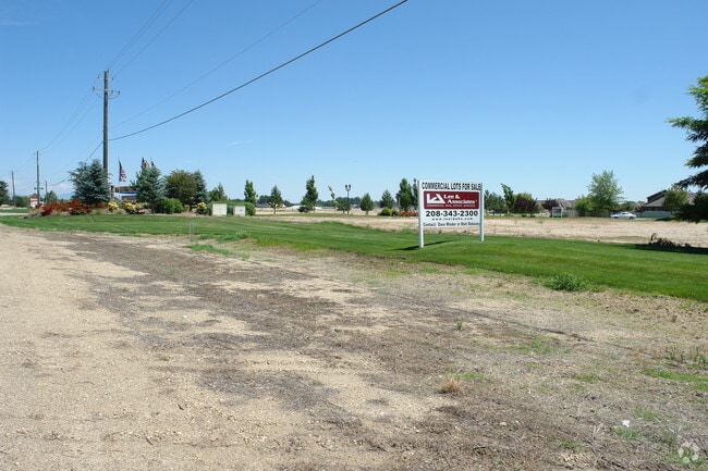
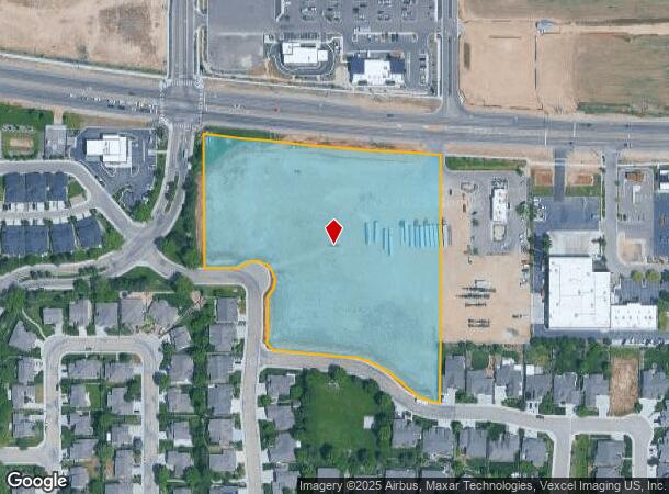
Property Record
11739 W State St, Star, ID 83669
NEARBY LISTINGS FOR SALE OR LEASE
Property Detail
11739 W State St
S0418120900
Pinewood Lakes Ph 07
Commercialacreage
PAR #0900 @NW COR NW4NE4 SEC 18 4N 1W #121100-S
X
Ada
16001C0125J
Idaho
2024
7.08 AC
2025
Star
010227
Boise City/Nampa
764 SF
Boise City, ID
DEMOGRAPHICS near 11739 W State St
1 Mile
3 Mile
5 Mile
2024 Total Population
6,862
17,390
48,472
2029 Population
7,864
20,166
56,668
Pop Growth 2024-2029
+ 14.60%
+ 15.96%
+ 16.91%
Average Age
41
42
41
2024 Total Households
2,426
6,066
16,414
HH Growth 2024-2029
+ 14.84%
+ 16.21%
+ 17.20%
Median Household Inc
$78,257
$85,483
$94,177
Avg Household Size
2.80
2.80
2.90
2024 Avg HH Vehicles
2.00
2.00
2.00
Median Home Value
$519,545
$599,637
$641,081
Median Year Built
2010
2010
2010
Nearby Places
Map Layers
Map Styles
 Street
 Aerial
- Restaurants
- Banks
- Shops
- Fitness
- Groceries
PUBLIC TRANSPORTATION
AIRPORT
Boise Air Trml/Gowen Field
DRIVE
WALK
Distance
Boise Air Trml/Gowen Field
48 min
25.8 mi
Freight Ports
Port of Portland
DRIVE
WALK
Distance
Port of Portland
460 min
413.5 mi
Nearby Properties
Address
Land Use
TOTAL SIZE
Lot Size
Zoning
Address
Land Use
TOTAL SIZE
Lot Size
Zoning
27,975 SF
40.88 AC
Address
Land Use
TOTAL SIZE
Lot Size
Zoning
15.16 AC
R-14-DA
Address
Land Use
TOTAL SIZE
Lot Size
Zoning
178,710 SF
13.47 AC
R-13
Address
Land Use
TOTAL SIZE
Lot Size
Zoning
227,392 SF
4.40 AC
L-O
Address
Land Use
TOTAL SIZE
Lot Size
Zoning
96,860 SF
12.62 AC
LI-DA
Address
Land Use
TOTAL SIZE
Lot Size
Zoning
174,428 SF
10 AC
MU
Address
Land Use
TOTAL SIZE
Lot Size
Zoning
246,075 SF
11.16 AC
C-2
Address
Land Use
TOTAL SIZE
Lot Size
Zoning
56,420 SF
10.27 AC
M1
Address
Land Use
TOTAL SIZE
Lot Size
Zoning
20,595 SF
2.32 AC
MU
Address
Land Use
TOTAL SIZE
Lot Size
Zoning
63,346 SF
6.87 AC
C-2
Address
Land Use
TOTAL SIZE
Lot Size
Zoning
132,187 SF
7.47 AC
MU
Address
Land Use
TOTAL SIZE
Lot Size
Zoning
58,697 SF
4.86 AC
CBD-DA
Address
Land Use
TOTAL SIZE
Lot Size
Zoning
34,510 SF
3.20 AC
C-2
Address
Land Use
TOTAL SIZE
Lot Size
Zoning
12.14 AC
C-G
Address
Land Use
TOTAL SIZE
Lot Size
Zoning
52.23 AC
R-3
Address
Land Use
TOTAL SIZE
Lot Size
Zoning
266,148 SF
10.42 AC
MU-DA
Address
Land Use
TOTAL SIZE
Lot Size
Zoning
1,940 SF
31.43 AC
R-2-DA
Address
Land Use
TOTAL SIZE
Lot Size
Zoning
24.88 AC
Address
Land Use
TOTAL SIZE
Lot Size
Zoning
4,839 SF
0.77 AC
CBD
Address
Land Use
TOTAL SIZE
Lot Size
Zoning
38,414 SF
4.66 AC
R-8
Address
Land Use
TOTAL SIZE
Lot Size
Zoning
946 SF
19.93 AC
R-4
Address
Land Use
TOTAL SIZE
Lot Size
Zoning
4,041 SF
0.60 AC
C-2
Address
Land Use
TOTAL SIZE
Lot Size
Zoning
12.78 AC
R-4-DA
Address
Land Use
TOTAL SIZE
Lot Size
Zoning
5.15 AC
C-G
Address
Land Use
TOTAL SIZE
Lot Size
Zoning
8,226 SF
1.74 AC
CBD-DA
Address
Land Use
TOTAL SIZE
Lot Size
Zoning
7,129 SF
1.11 AC
C-2
Address
Land Use
TOTAL SIZE
Lot Size
Zoning
9,294 SF
1.07 AC
MU-DA
Address
Land Use
TOTAL SIZE
Lot Size
Zoning
5,215 SF
0.93 AC
C-1-DA
Address
Land Use
TOTAL SIZE
Lot Size
Zoning
4,268 SF
0.93 AC
CBD
Address
Land Use
TOTAL SIZE
Lot Size
Zoning
17.21 AC
R-8
The World's #1 Commercial Real Estate Marketplace
Connect with us
© 2025 CoStar Group
The information above has been obtained from sources believed reliable. While we do not doubt its accuracy we have not verified it and make no guarantee, warranty or representation about it. It is your responsibility to independently confirm its accuracy and completeness. Any projections, opinions, assumptions, or estimates used are for example only and do not represent the current or future performance of the property. The value of this transaction to you depends on tax and other factors which should be evaluated by your tax, financial, and legal advisors. You and your advisors should conduct a careful, independent investigation of the property to determine to your satisfaction the suitability of the property for your needs.