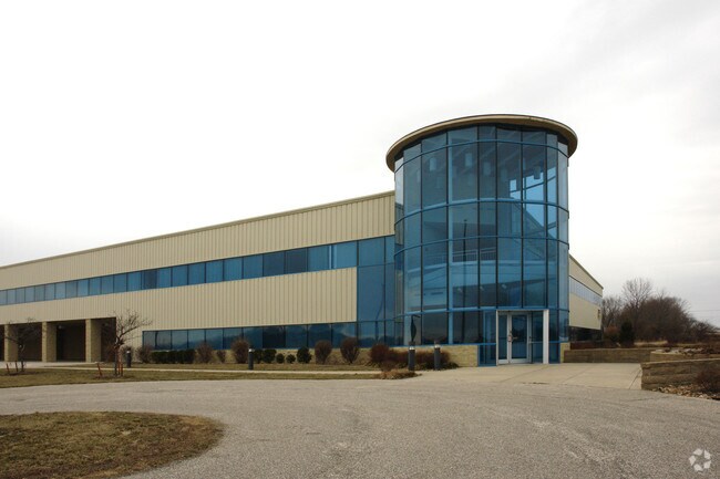
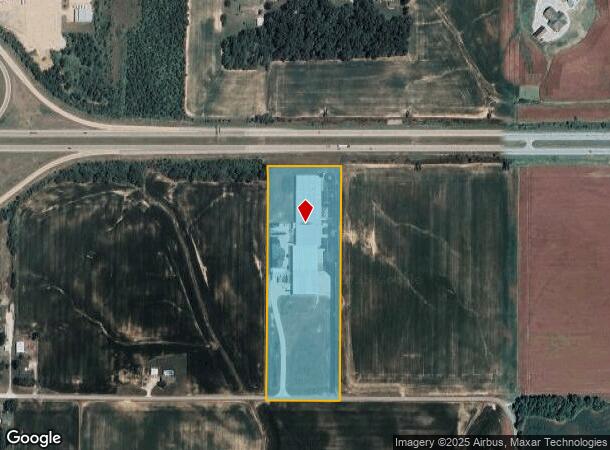
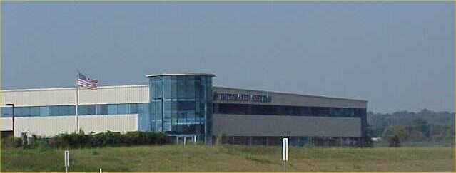
Property Record
11744 Blue Bell Rd, Elberfeld, IN 47613

NEARBY LISTINGS FOR SALE OR LEASE
Property Detail
11744 Blue Bell Rd
87-04-18-300-063.000-007
PT E 1/2 SW S18 T4 R9 15.00 A PARCEL 1 EXEMPT DIVISION DOC # 1998R 011016
Warehouse
Warrick
X
Indiana
18051C0450E
15 AC
2024
Warrick County
2024
Evansville
030200
Evansville, IN-KY
110,526 SF
DEMOGRAPHICS near 11744 Blue Bell Rd
1 Mile
3 Mile
5 Mile
2024 Total Population
577
2,273
4,956
2029 Population
594
2,318
5,008
Pop Growth 2024-2029
+ 2.95%
+ 1.98%
+ 1.05%
Average Age
40
41
41
2024 Total Households
224
883
1,876
HH Growth 2024-2029
+ 2.68%
+ 1.93%
+ 1.01%
Median Household Inc
$101,087
$97,996
$95,788
Avg Household Size
2.60
2.60
2.60
2024 Avg HH Vehicles
3.00
3.00
3.00
Median Home Value
$194,666
$234,434
$257,142
Median Year Built
1969
1971
1978
Nearby Places
Map Layers
Map Styles
 Street
 Aerial
- Restaurants
- Banks
- Shops
- Fitness
- Groceries
PUBLIC TRANSPORTATION
AIRPORT
Evansville Regional
DRIVE
WALK
Distance
Evansville Regional
25 min
11.5 mi
Freight Ports
Port of Toledo
DRIVE
WALK
Distance
Port of Toledo
445 min
379.0 mi
Nearby Properties
Address
Land Use
TOTAL SIZE
Lot Size
Zoning
Address
Land Use
TOTAL SIZE
Lot Size
Zoning
80,000 SF
6.97 AC
Address
Land Use
TOTAL SIZE
Lot Size
Zoning
33,864 SF
9.58 AC
Address
Land Use
TOTAL SIZE
Lot Size
Zoning
10,430 SF
5.90 AC
Address
Land Use
TOTAL SIZE
Lot Size
Zoning
Address
Land Use
TOTAL SIZE
Lot Size
Zoning
42,200 SF
4.99 AC
Address
Land Use
TOTAL SIZE
Lot Size
Zoning
9,220 SF
1.75 AC
Address
Land Use
TOTAL SIZE
Lot Size
Zoning
7,200 SF
5.32 AC
Address
Land Use
TOTAL SIZE
Lot Size
Zoning
21.85 AC
M-2
Address
Land Use
TOTAL SIZE
Lot Size
Zoning
15,654 SF
4.66 AC
Address
Land Use
TOTAL SIZE
Lot Size
Zoning
4,232 SF
0.09 AC
Address
Land Use
TOTAL SIZE
Lot Size
Zoning
Address
Land Use
TOTAL SIZE
Lot Size
Zoning
160 AC
Address
Land Use
TOTAL SIZE
Lot Size
Zoning
Address
Land Use
TOTAL SIZE
Lot Size
Zoning
1,424 SF
139.84 AC
Address
Land Use
TOTAL SIZE
Lot Size
Zoning
6,932 SF
0.84 AC
Address
Land Use
TOTAL SIZE
Lot Size
Zoning
16,555 SF
4.48 AC
Address
Land Use
TOTAL SIZE
Lot Size
Zoning
3,000 SF
0.78 AC
Address
Land Use
TOTAL SIZE
Lot Size
Zoning
6,634 SF
0.15 AC
Address
Land Use
TOTAL SIZE
Lot Size
Zoning
2,916 SF
28.84 AC
M-2
Address
Land Use
TOTAL SIZE
Lot Size
Zoning
2,334 SF
1.64 AC
Address
Land Use
TOTAL SIZE
Lot Size
Zoning
28,225 SF
1.88 AC
Address
Land Use
TOTAL SIZE
Lot Size
Zoning
3,165 SF
0.18 AC
Address
Land Use
TOTAL SIZE
Lot Size
Zoning
2,651 SF
0.08 AC
Address
Land Use
TOTAL SIZE
Lot Size
Zoning
63.02 AC
Address
Land Use
TOTAL SIZE
Lot Size
Zoning
Address
Land Use
TOTAL SIZE
Lot Size
Zoning
Address
Land Use
TOTAL SIZE
Lot Size
Zoning
10 AC
Address
Land Use
TOTAL SIZE
Lot Size
Zoning
Address
Land Use
TOTAL SIZE
Lot Size
Zoning
6,440 SF
4.05 AC
The World's #1 Commercial Real Estate Marketplace
Connect with us
© 2026 CoStar Group
The information above has been obtained from sources believed reliable. While we do not doubt its accuracy we have not verified it and make no guarantee, warranty or representation about it. It is your responsibility to independently confirm its accuracy and completeness. Any projections, opinions, assumptions, or estimates used are for example only and do not represent the current or future performance of the property. The value of this transaction to you depends on tax and other factors which should be evaluated by your tax, financial, and legal advisors. You and your advisors should conduct a careful, independent investigation of the property to determine to your satisfaction the suitability of the property for your needs.