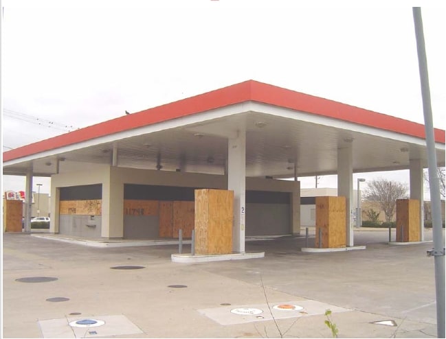
Property Record
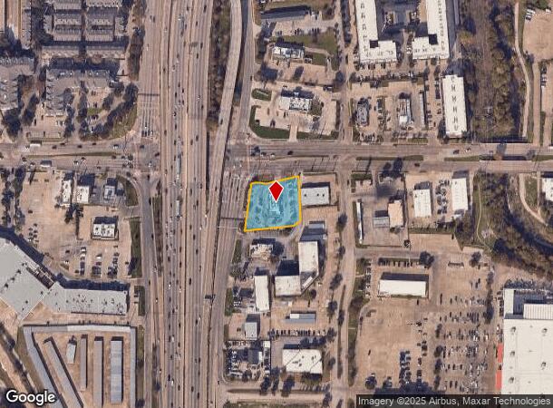
11748 N Central Expy, Dallas, TX 75243
NEARBY LISTINGS FOR SALE OR LEASE
Property Detail
11748 N Central Expy
Dallas-Fort Worth-Arlington, TX
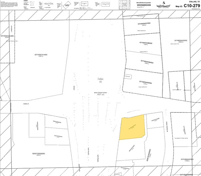
Exxon Expressway No 1
0077450A000060000
EXXON EXPRESSWAY NO 1 BLK A/7745 LOT 6 0.731 ACS INT20080215871 DD06302008 CO-DC 7745 A00 00600 3DA7745 A00
Restaurantdrivein
Dallas
X
Texas
48113C0195K
6
2024
0.73 AC
2025
Upper Greenville
007805
Dallas/Ft Worth
2,815 SF
DEMOGRAPHICS near 11748 N Central Expy
1 Mile
3 Mile
5 Mile
2024 Total Population
12,478
154,085
404,595
2029 Population
12,518
153,973
403,133
Pop Growth 2024-2029
+ 0.32%
(0.07%)
(0.36%)
Average Age
41
37
37
2024 Total Households
6,328
66,157
172,618
HH Growth 2024-2029
+ 0.24%
(0.14%)
(0.39%)
Median Household Inc
$72,524
$58,513
$68,327
Avg Household Size
1.90
2.30
2.30
2024 Avg HH Vehicles
1.00
2.00
2.00
Median Home Value
$491,269
$516,805
$460,039
Median Year Built
1981
1978
1978
Nearby Places
Map Layers
Map Styles
 Street
 Aerial
- Restaurants
- Banks
- Shops
- Fitness
- Groceries
PUBLIC TRANSPORTATION
TRANSIT/SUBWAY
Forest Lane (DART LIGHT RAIL - ORANGE LINE - Dallas Area Rapid Transit (DART), DART LIGHT RAIL - RED LINE - Dallas Area Rapid Transit (DART), Orange Line - Dallas Area Rapid Transit (DART), Red Line - Dallas Area Rapid Transit (DART))
DRIVE
WALK
Distance
Forest Lane (DART LIGHT RAIL - ORANGE LINE - Dallas Area Rapid Transit (DART), DART LIGHT RAIL - RED LINE - Dallas Area Rapid Transit (DART), Orange Line - Dallas Area Rapid Transit (DART), Red Line - Dallas Area Rapid Transit (DART))
1 min
8 min
0.4 mi
AIRPORT
Dallas Love Field
DRIVE
WALK
Distance
Dallas Love Field
18 min
9.9 mi
Dallas-Fort Worth International
DRIVE
WALK
Distance
Dallas-Fort Worth International
29 min
22.6 mi
Freight Ports
Port of Shreveport
DRIVE
WALK
Distance
Port of Shreveport
215 min
198.6 mi
Nearby Properties
Address
Land Use
TOTAL SIZE
Lot Size
Zoning
Address
Land Use
TOTAL SIZE
Lot Size
Zoning
4,157,377 SF
76.79 AC
Z248
Address
Land Use
TOTAL SIZE
Lot Size
Zoning
3,240,143 SF
28.52 AC
Z151
Address
Land Use
TOTAL SIZE
Lot Size
Zoning
7,706,477 SF
245.55 AC
Z116
Address
Land Use
TOTAL SIZE
Lot Size
Zoning
2,186,362 SF
48.27 AC
Z239
Address
Land Use
TOTAL SIZE
Lot Size
Zoning
1,252,860 SF
57.08 AC
Z239
Address
Land Use
TOTAL SIZE
Lot Size
Zoning
3,423,779 SF
32.42 AC
Z151
Address
Land Use
TOTAL SIZE
Lot Size
Zoning
77.76 AC
Z239
Address
Land Use
TOTAL SIZE
Lot Size
Zoning
1,086,919 SF
5.85 AC
Z239
Address
Land Use
TOTAL SIZE
Lot Size
Zoning
557,392 SF
10.06 AC
Z239
Address
Land Use
TOTAL SIZE
Lot Size
Zoning
835,301 SF
9.29 AC
Z239
Address
Land Use
TOTAL SIZE
Lot Size
Zoning
421,798 SF
9 AC
Z151
Address
Land Use
TOTAL SIZE
Lot Size
Zoning
852,562 SF
13.86 AC
Z151
Address
Land Use
TOTAL SIZE
Lot Size
Zoning
706,061 SF
36.76 AC
Z109
Address
Land Use
TOTAL SIZE
Lot Size
Zoning
428,956 SF
18.76 AC
Z291
Address
Land Use
TOTAL SIZE
Lot Size
Zoning
184,388 SF
18.89 AC
Z298
Address
Land Use
TOTAL SIZE
Lot Size
Zoning
485,067 SF
14.87 AC
Z239
Address
Land Use
TOTAL SIZE
Lot Size
Zoning
462,916 SF
15.67 AC
Z248
Address
Land Use
TOTAL SIZE
Lot Size
Zoning
249,692 SF
244.62 AC
Z239
Address
Land Use
TOTAL SIZE
Lot Size
Zoning
1,009,203 SF
33.32 AC
Z125
Address
Land Use
TOTAL SIZE
Lot Size
Zoning
595,526 SF
6.92 AC
Z151
Address
Land Use
TOTAL SIZE
Lot Size
Zoning
379,592 SF
12.75 AC
Z248
Address
Land Use
TOTAL SIZE
Lot Size
Zoning
592,314 SF
4.19 AC
Z96
Address
Land Use
TOTAL SIZE
Lot Size
Zoning
456,300 SF
10.92 AC
Z239
Address
Land Use
TOTAL SIZE
Lot Size
Zoning
573,575 SF
6.43 AC
Z239
Address
Land Use
TOTAL SIZE
Lot Size
Zoning
227,323 SF
40.40 AC
Z239
Address
Land Use
TOTAL SIZE
Lot Size
Zoning
999,432 SF
5.78 AC
Z96
Address
Land Use
TOTAL SIZE
Lot Size
Zoning
424,666 SF
12.19 AC
Z151
Address
Land Use
TOTAL SIZE
Lot Size
Zoning
900,244 SF
7.03 AC
Z96
Address
Land Use
TOTAL SIZE
Lot Size
Zoning
597,248 SF
6.61 AC
Z239
Address
Land Use
TOTAL SIZE
Lot Size
Zoning
316,085 SF
13.73 AC
Z107
The World's #1 Commercial Real Estate Marketplace
Connect with us
© 2025 CoStar Group
The information above has been obtained from sources believed reliable. While we do not doubt its accuracy we have not verified it and make no guarantee, warranty or representation about it. It is your responsibility to independently confirm its accuracy and completeness. Any projections, opinions, assumptions, or estimates used are for example only and do not represent the current or future performance of the property. The value of this transaction to you depends on tax and other factors which should be evaluated by your tax, financial, and legal advisors. You and your advisors should conduct a careful, independent investigation of the property to determine to your satisfaction the suitability of the property for your needs.