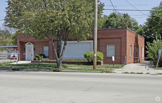
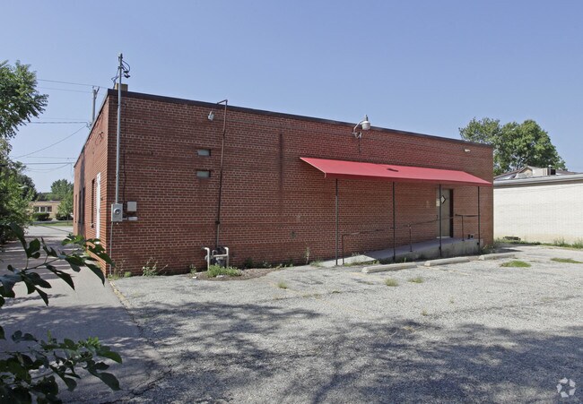
Property Record
1175 Madison Rd, Beloit, WI 53511

Property Detail
1175 Madison Rd
Janesville-Beloit, WI
L 2 & SELY 36 FT L 3 LATHERS SUB BEING PART OF MOSELEYS ADD, ALSO PART OF L 30 MOSELEYS ADD COM 161.57 FT ELY OF SW COR L 30, TH NLY 68.98 FT, TH SWLY 107 .73FT, TH ELY 97 FT TO POB
127-41035
ROCK
Municipalproperty
Wisconsin
B and X Area of moderate flood hazard, usually the area between the limits of the 100-year and 500-year floods.
2
0
0.26 AC
2025
Rock County
002100
Milwaukee/Madison
3,069 SF
NEARBY LISTINGS FOR SALE OR LEASE
DEMOGRAPHICS near 1175 Madison Rd
1 mile
3 mile
5 mile
2025 Total Population
13,605
41,830
65,809
2030 Population
13,660
42,136
66,313
Pop Growth 2025-2030
+ 0.40%
+ 0.73%
+ 0.77%
Average Age
38
39
40
2025 Total Households
5,179
16,154
25,615
HH Growth 2025-2030
+ 0.29%
+ 0.74%
+ 0.78%
Median Household Inc
$56,122
$59,229
$69,249
Avg Household Size
2.50
2.40
2.40
2025 Avg HH Vehicles
2.00
2.00
2.00
Median Home Value
$137,964
$154,673
$185,790
Median Year Built
1950
1956
1967
Nearby Places
Map Layers
Map Styles
 Street
 Aerial
Transit
 Traffic
 Biking
Places
Listings with unknown addresses are not visible on the map
- Restaurants
- Banks
- Shops
- Fitness
- Groceries
PUBLIC TRANSPORTATION
AIRPORT
Chicago/Rockford International
Drive
Walk
Distance
Chicago/Rockford International
46 min
33.6 mi
Nearby Properties
Address
Land Use
TOTAL SIZE
Lot Size
Zoning
Address
Land Use
TOTAL SIZE
Lot Size
Zoning
202,676 SF
19.31 AC
Address
Land Use
TOTAL SIZE
Lot Size
Zoning
186,691 SF
17.06 AC
Address
Land Use
TOTAL SIZE
Lot Size
Zoning
3.39 AC
Address
Land Use
TOTAL SIZE
Lot Size
Zoning
3.47 AC
Address
Land Use
TOTAL SIZE
Lot Size
Zoning
3.65 AC
Address
Land Use
TOTAL SIZE
Lot Size
Zoning
361,947 SF
23.26 AC
Address
Land Use
TOTAL SIZE
Lot Size
Zoning
38,012 SF
2.74 AC
Address
Land Use
TOTAL SIZE
Lot Size
Zoning
32.79 AC
Address
Land Use
TOTAL SIZE
Lot Size
Zoning
296,731 SF
18.14 AC
Address
Land Use
TOTAL SIZE
Lot Size
Zoning
131,218 SF
1.65 AC
Address
Land Use
TOTAL SIZE
Lot Size
Zoning
48,036 SF
1.26 AC
Address
Land Use
TOTAL SIZE
Lot Size
Zoning
125,000 SF
12.53 AC
Address
Land Use
TOTAL SIZE
Lot Size
Zoning
7.57 AC
Address
Land Use
TOTAL SIZE
Lot Size
Zoning
47,561 SF
0.58 AC
Address
Land Use
TOTAL SIZE
Lot Size
Zoning
10,456 SF
3.58 AC
Address
Land Use
TOTAL SIZE
Lot Size
Zoning
264,754 SF
6.49 AC
Address
Land Use
TOTAL SIZE
Lot Size
Zoning
82,412 SF
3.94 AC
Address
Land Use
TOTAL SIZE
Lot Size
Zoning
57,745 SF
9.57 AC
Address
Land Use
TOTAL SIZE
Lot Size
Zoning
84,000 SF
7.15 AC
Address
Land Use
TOTAL SIZE
Lot Size
Zoning
45,972 SF
0.64 AC
Address
Land Use
TOTAL SIZE
Lot Size
Zoning
103.62 AC
Address
Land Use
TOTAL SIZE
Lot Size
Zoning
6.79 AC
Address
Land Use
TOTAL SIZE
Lot Size
Zoning
66,654 SF
1.72 AC
Address
Land Use
TOTAL SIZE
Lot Size
Zoning
21,952 SF
2.14 AC
Address
Land Use
TOTAL SIZE
Lot Size
Zoning
21,952 SF
2.14 AC
Address
Land Use
TOTAL SIZE
Lot Size
Zoning
23,715 SF
1.59 AC
Address
Land Use
TOTAL SIZE
Lot Size
Zoning
16,024 SF
6.19 AC
Address
Land Use
TOTAL SIZE
Lot Size
Zoning
42,958 SF
3.83 AC
Address
Land Use
TOTAL SIZE
Lot Size
Zoning
46,060 SF
4.63 AC
Address
Land Use
TOTAL SIZE
Lot Size
Zoning
0.39 AC
The World's #1 Commercial Real Estate Marketplace
Connect with us
© 2026 CoStar Group
The information above has been obtained from sources believed reliable. While we do not doubt its accuracy we have not verified it and make no guarantee, warranty or representation about it. It is your responsibility to independently confirm its accuracy and completeness. Any projections, opinions, assumptions, or estimates used are for example only and do not represent the current or future performance of the property. The value of this transaction to you depends on tax and other factors which should be evaluated by your tax, financial, and legal advisors. You and your advisors should conduct a careful, independent investigation of the property to determine to your satisfaction the suitability of the property for your needs.