Property Record
1175 Newstar Way, Golden, CO 80403
NEARBY LISTINGS FOR SALE OR LEASE
Property Detail
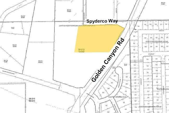
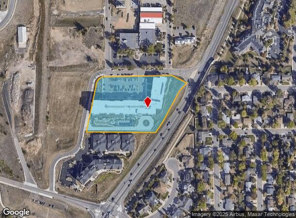
1175 Newstar Way
Denver-Aurora-Centennial, CO
Canyon View Business Park Flg 2 Replat B
30-213-13-004
SECTION 21 TOWNSHIP 03 RANGE 70 SUBDIVISIONCD 108786 SUBDIVISIONNAME CANYON VIEW BUSINESS PARK FLG 2 REPLAT B LOT 0002 SIZE: 171626 VALUE: 3.940
Commercialnec
Jefferson
X
Colorado
08059C0188G
2
2023
3.94 AC
2024
West Denver
009858
Denver
102,645 SF
DEMOGRAPHICS near 1175 Newstar Way
1 mile
3 mile
5 mile
2024 Total Population
4,463
18,627
54,462
2029 Population
4,481
18,601
54,074
Pop Growth 2024-2029
+ 0.40%
(0.14%)
(0.71%)
Average Age
43
39
41
2024 Total Households
1,872
6,998
21,199
HH Growth 2024-2029
+ 0.48%
+ 0.03%
(0.75%)
Median Household Inc
$124,029
$106,372
$114,553
Avg Household Size
2.40
2.30
2.40
2024 Avg HH Vehicles
2.00
2.00
2.00
Median Home Value
$760,131
$741,731
$717,433
Median Year Built
1992
1987
1990
Nearby Places
Map Layers
Map Styles
 Street
 Aerial
Transit
 Traffic
 Biking
Places
Listings with unknown addresses are not visible on the map
- Restaurants
- Banks
- Shops
- Fitness
- Groceries
PUBLIC TRANSPORTATION
COMMUTER RAIL
Wheat Ridge - Ward Station Track 1 (Union Station to Wheat Ridge Ward Station - Regional Transportation District)
Drive
Walk
Distance
Wheat Ridge - Ward Station Track 1 (Union Station to Wheat Ridge Ward Station - Regional Transportation District)
14 min
8.2 mi
Arvada Ridge Station Track 1 (Union Station to Wheat Ridge Ward Station - Regional Transportation District)
Drive
Walk
Distance
Arvada Ridge Station Track 1 (Union Station to Wheat Ridge Ward Station - Regional Transportation District)
15 min
9.2 mi
Freight Ports
Tulsa Port Of Catoosa
Drive
Walk
Distance
Tulsa Port Of Catoosa
745 min
722.3 mi
Nearby Properties
Address
Land Use
TOTAL SIZE
Lot Size
Zoning
Address
Land Use
TOTAL SIZE
Lot Size
Zoning
3,357,529 SF
32.87 AC
Address
Land Use
TOTAL SIZE
Lot Size
Zoning
69,819 SF
1,402.21 AC
R1
Address
Land Use
TOTAL SIZE
Lot Size
Zoning
589,966 SF
23.48 AC
Address
Land Use
TOTAL SIZE
Lot Size
Zoning
156,531 SF
8.20 AC
Address
Land Use
TOTAL SIZE
Lot Size
Zoning
188,554 SF
33.28 AC
Address
Land Use
TOTAL SIZE
Lot Size
Zoning
353,286 SF
14.49 AC
Address
Land Use
TOTAL SIZE
Lot Size
Zoning
227,132 SF
11.95 AC
Address
Land Use
TOTAL SIZE
Lot Size
Zoning
1,115,227 SF
84.74 AC
I2
Address
Land Use
TOTAL SIZE
Lot Size
Zoning
192,500 SF
10.97 AC
Address
Land Use
TOTAL SIZE
Lot Size
Zoning
260,325 SF
13.70 AC
Address
Land Use
TOTAL SIZE
Lot Size
Zoning
350,722 SF
73.85 AC
R1
Address
Land Use
TOTAL SIZE
Lot Size
Zoning
454.79 AC
A2
Address
Land Use
TOTAL SIZE
Lot Size
Zoning
391,506 SF
10.02 AC
Address
Land Use
TOTAL SIZE
Lot Size
Zoning
240,059 SF
58.36 AC
Address
Land Use
TOTAL SIZE
Lot Size
Zoning
149,760 SF
8.64 AC
Address
Land Use
TOTAL SIZE
Lot Size
Zoning
64,883 SF
4.74 AC
Address
Land Use
TOTAL SIZE
Lot Size
Zoning
82,432 SF
1.62 AC
Address
Land Use
TOTAL SIZE
Lot Size
Zoning
68,500 SF
5.84 AC
Address
Land Use
TOTAL SIZE
Lot Size
Zoning
173,498 SF
42.86 AC
Address
Land Use
TOTAL SIZE
Lot Size
Zoning
197,699 SF
Address
Land Use
TOTAL SIZE
Lot Size
Zoning
83,450 SF
7.22 AC
Address
Land Use
TOTAL SIZE
Lot Size
Zoning
180,193 SF
4.58 AC
Address
Land Use
TOTAL SIZE
Lot Size
Zoning
64,050 SF
6.07 AC
Address
Land Use
TOTAL SIZE
Lot Size
Zoning
65,682 SF
6 AC
Address
Land Use
TOTAL SIZE
Lot Size
Zoning
910,977 SF
19.78 AC
Address
Land Use
TOTAL SIZE
Lot Size
Zoning
43,360 SF
5.48 AC
Address
Land Use
TOTAL SIZE
Lot Size
Zoning
143,558 SF
2.93 AC
Address
Land Use
TOTAL SIZE
Lot Size
Zoning
61,315 SF
8 AC
Address
Land Use
TOTAL SIZE
Lot Size
Zoning
50,240 SF
5.85 AC
The World's #1 Commercial Real Estate Marketplace
Connect with us
© 2026 CoStar Group
The information above has been obtained from sources believed reliable. While we do not doubt its accuracy we have not verified it and make no guarantee, warranty or representation about it. It is your responsibility to independently confirm its accuracy and completeness. Any projections, opinions, assumptions, or estimates used are for example only and do not represent the current or future performance of the property. The value of this transaction to you depends on tax and other factors which should be evaluated by your tax, financial, and legal advisors. You and your advisors should conduct a careful, independent investigation of the property to determine to your satisfaction the suitability of the property for your needs.