Property Record
1175 State Rd, Westport, MA 02790
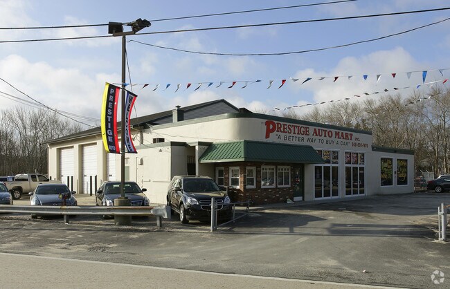

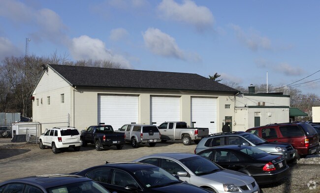
Property Detail
1175 State Rd
WPOR-000028-000000-000022A
Bristol
Vehiclerentalsvehiclesales
Massachusetts
R1
22a
B and X Area of moderate flood hazard, usually the area between the limits of the 100-year and 500-year floods.
4.20 AC
2025
Attleboro/New Bedford
2025
Boston
646101
Providence-Warwick, RI-MA
11,265 SF
NEARBY LISTINGS FOR SALE OR LEASE
DEMOGRAPHICS near 1175 State Rd
1 mile
3 mile
5 mile
2025 Total Population
2,226
14,482
41,046
2030 Population
2,262
14,766
41,720
Pop Growth 2025-2030
+ 1.62%
+ 1.96%
+ 1.64%
Average Age
45
43
44
2025 Total Households
962
5,513
15,611
HH Growth 2025-2030
+ 1.56%
+ 2.03%
+ 1.65%
Median Household Inc
$86,153
$88,836
$90,925
Avg Household Size
2.30
2.40
2.40
2025 Avg HH Vehicles
2.00
2.00
2.00
Median Home Value
$519,290
$538,289
$485,072
Median Year Built
1972
1975
1975
Nearby Places
Map Layers
Map Styles
 Street
 Aerial
Transit
 Traffic
 Biking
Places
Listings with unknown addresses are not visible on the map
- Restaurants
- Banks
- Shops
- Fitness
- Groceries
PUBLIC TRANSPORTATION
AIRPORT
Rhode Island Tf Green International
Drive
Walk
Distance
Rhode Island Tf Green International
47 min
31.3 mi
Freight Ports
Port of New Bedford Harbor
Drive
Walk
Distance
Port of New Bedford Harbor
15 min
9.2 mi
Nearby Properties
Address
Land Use
TOTAL SIZE
Lot Size
Zoning
Address
Land Use
TOTAL SIZE
Lot Size
Zoning
120,000 SF
705.15 AC
SRB
Address
Land Use
TOTAL SIZE
Lot Size
Zoning
36.70 AC
E1
Address
Land Use
TOTAL SIZE
Lot Size
Zoning
30.28 AC
GB
Address
Land Use
TOTAL SIZE
Lot Size
Zoning
3,792 SF
33 AC
GB
Address
Land Use
TOTAL SIZE
Lot Size
Zoning
14,840 SF
26.26 AC
SRA
Address
Land Use
TOTAL SIZE
Lot Size
Zoning
12.94 AC
GB
Address
Land Use
TOTAL SIZE
Lot Size
Zoning
174,416 SF
29.20 AC
CEMETA
Address
Land Use
TOTAL SIZE
Lot Size
Zoning
126,745 SF
15.82 AC
GB
Address
Land Use
TOTAL SIZE
Lot Size
Zoning
111,708 SF
17 AC
GB
Address
Land Use
TOTAL SIZE
Lot Size
Zoning
146,599 SF
22.98 AC
GB
Address
Land Use
TOTAL SIZE
Lot Size
Zoning
17.54 AC
GB
Address
Land Use
TOTAL SIZE
Lot Size
Zoning
106,755 SF
17.01 AC
GB
Address
Land Use
TOTAL SIZE
Lot Size
Zoning
65,424 SF
10.69 AC
SRB
Address
Land Use
TOTAL SIZE
Lot Size
Zoning
141,102 SF
9.35 AC
GB
Address
Land Use
TOTAL SIZE
Lot Size
Zoning
62,336 SF
9.85 AC
SRB
Address
Land Use
TOTAL SIZE
Lot Size
Zoning
51,709 SF
2.32 AC
GB
Address
Land Use
TOTAL SIZE
Lot Size
Zoning
Address
Land Use
TOTAL SIZE
Lot Size
Zoning
17,610 SF
3.07 AC
GB
Address
Land Use
TOTAL SIZE
Lot Size
Zoning
21.38 AC
LI
Address
Land Use
TOTAL SIZE
Lot Size
Zoning
3.42 AC
GB
Address
Land Use
TOTAL SIZE
Lot Size
Zoning
43,300 SF
11.63 AC
SRB
Address
Land Use
TOTAL SIZE
Lot Size
Zoning
31,444 SF
13 AC
E1
Address
Land Use
TOTAL SIZE
Lot Size
Zoning
55,908 SF
13.72 AC
LI
Address
Land Use
TOTAL SIZE
Lot Size
Zoning
53,708 SF
2.19 AC
GB
Address
Land Use
TOTAL SIZE
Lot Size
Zoning
11,976 SF
2.34 AC
R1
Address
Land Use
TOTAL SIZE
Lot Size
Zoning
9,292 SF
4.29 AC
SRB
Address
Land Use
TOTAL SIZE
Lot Size
Zoning
63,300 SF
6 AC
LI
Address
Land Use
TOTAL SIZE
Lot Size
Zoning
6.67 AC
GB
Address
Land Use
TOTAL SIZE
Lot Size
Zoning
14,033 SF
1.86 AC
HISTOR
Address
Land Use
TOTAL SIZE
Lot Size
Zoning
6.49 AC
LI
The World's #1 Commercial Real Estate Marketplace
Connect with us
© 2026 CoStar Group
The information above has been obtained from sources believed reliable. While we do not doubt its accuracy we have not verified it and make no guarantee, warranty or representation about it. It is your responsibility to independently confirm its accuracy and completeness. Any projections, opinions, assumptions, or estimates used are for example only and do not represent the current or future performance of the property. The value of this transaction to you depends on tax and other factors which should be evaluated by your tax, financial, and legal advisors. You and your advisors should conduct a careful, independent investigation of the property to determine to your satisfaction the suitability of the property for your needs.