Property Record
1175 Walnut Bottom Rd, Carlisle, PA 17015

NEARBY LISTINGS FOR SALE OR LEASE
Property Detail
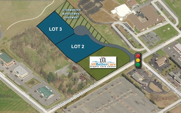
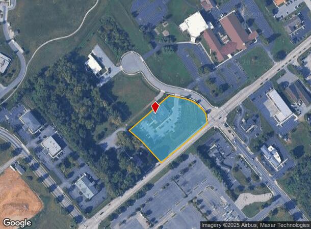
1175 Walnut Bottom Rd
40-09-0527-015
WENGER DEVELOPMENT LOT 1 & PAR B PL INSTR#2013-05367
Medicalbuilding
Cumberland
X
Pennsylvania
42041C0240F
1
2025
2.19 AC
2025
Harrisburg Area West
012501
Philadelphia
1,984 SF
Harrisburg-Carlisle, PA
DEMOGRAPHICS near 1175 Walnut Bottom Rd
1 Mile
3 Mile
5 Mile
2024 Total Population
2,828
29,196
54,552
2029 Population
2,962
31,269
58,333
Pop Growth 2024-2029
+ 4.74%
+ 7.10%
+ 6.93%
Average Age
51
40
41
2024 Total Households
1,309
11,966
21,902
HH Growth 2024-2029
+ 4.58%
+ 7.10%
+ 7.05%
Median Household Inc
$79,551
$66,017
$75,527
Avg Household Size
2.00
2.20
2.30
2024 Avg HH Vehicles
2.00
2.00
2.00
Median Home Value
$249,875
$215,472
$226,303
Median Year Built
1985
1964
1972
Nearby Places
Map Layers
Map Styles
 Street
 Aerial
- Restaurants
- Banks
- Shops
- Fitness
- Groceries
PUBLIC TRANSPORTATION
AIRPORT
Harrisburg International
DRIVE
WALK
Distance
Harrisburg International
47 min
33.1 mi
Freight Ports
Port of Baltimore
DRIVE
WALK
Distance
Port of Baltimore
117 min
82.2 mi
Nearby Properties
Address
Land Use
TOTAL SIZE
Lot Size
Zoning
Address
Land Use
TOTAL SIZE
Lot Size
Zoning
Address
Land Use
TOTAL SIZE
Lot Size
Zoning
85.35 AC
Address
Land Use
TOTAL SIZE
Lot Size
Zoning
103.91 AC
Address
Land Use
TOTAL SIZE
Lot Size
Zoning
104.05 AC
Address
Land Use
TOTAL SIZE
Lot Size
Zoning
13.47 AC
Address
Land Use
TOTAL SIZE
Lot Size
Zoning
Address
Land Use
TOTAL SIZE
Lot Size
Zoning
34.64 AC
Address
Land Use
TOTAL SIZE
Lot Size
Zoning
Address
Land Use
TOTAL SIZE
Lot Size
Zoning
61.67 AC
Address
Land Use
TOTAL SIZE
Lot Size
Zoning
75.75 AC
Address
Land Use
TOTAL SIZE
Lot Size
Zoning
68.59 AC
Address
Land Use
TOTAL SIZE
Lot Size
Zoning
73.72 AC
Address
Land Use
TOTAL SIZE
Lot Size
Zoning
49.12 AC
Address
Land Use
TOTAL SIZE
Lot Size
Zoning
69.54 AC
Address
Land Use
TOTAL SIZE
Lot Size
Zoning
54.41 AC
Address
Land Use
TOTAL SIZE
Lot Size
Zoning
42.01 AC
Address
Land Use
TOTAL SIZE
Lot Size
Zoning
50.39 AC
Address
Land Use
TOTAL SIZE
Lot Size
Zoning
51.73 AC
Address
Land Use
TOTAL SIZE
Lot Size
Zoning
1.75 AC
Address
Land Use
TOTAL SIZE
Lot Size
Zoning
38.95 AC
Address
Land Use
TOTAL SIZE
Lot Size
Zoning
0.55 AC
Address
Land Use
TOTAL SIZE
Lot Size
Zoning
32.83 AC
Address
Land Use
TOTAL SIZE
Lot Size
Zoning
45.20 AC
Address
Land Use
TOTAL SIZE
Lot Size
Zoning
7.81 AC
Address
Land Use
TOTAL SIZE
Lot Size
Zoning
41.39 AC
Address
Land Use
TOTAL SIZE
Lot Size
Zoning
53.17 AC
Address
Land Use
TOTAL SIZE
Lot Size
Zoning
31.85 AC
Address
Land Use
TOTAL SIZE
Lot Size
Zoning
31.47 AC
Address
Land Use
TOTAL SIZE
Lot Size
Zoning
36.48 AC
Address
Land Use
TOTAL SIZE
Lot Size
Zoning
6.86 AC
The World's #1 Commercial Real Estate Marketplace
Connect with us
© 2025 CoStar Group
The information above has been obtained from sources believed reliable. While we do not doubt its accuracy we have not verified it and make no guarantee, warranty or representation about it. It is your responsibility to independently confirm its accuracy and completeness. Any projections, opinions, assumptions, or estimates used are for example only and do not represent the current or future performance of the property. The value of this transaction to you depends on tax and other factors which should be evaluated by your tax, financial, and legal advisors. You and your advisors should conduct a careful, independent investigation of the property to determine to your satisfaction the suitability of the property for your needs.