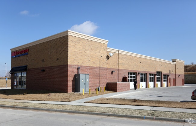
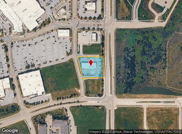
Property Record
11751 S 73Rd St, Papillion, NE 68046
NEARBY LISTINGS FOR SALE OR LEASE
Property Detail
11751 S 73Rd St
Omaha-Council Bluffs, NE-IA
Shadow Lake
011592678
LOT 3 SHADOW LAKE TOWNE CENTER REPLAT 4
Commercialnec
Sarpy
X
Nebraska
31153C0069H
3
2024
1.11 AC
2025
Sarpy East
010620
Omaha/Council Bluffs
6,380 SF
DEMOGRAPHICS near 11751 S 73Rd St
1 Mile
3 Mile
5 Mile
2024 Total Population
7,456
46,094
122,455
2029 Population
8,039
49,769
131,146
Pop Growth 2024-2029
+ 7.82%
+ 7.97%
+ 7.10%
Average Age
39
38
38
2024 Total Households
3,002
16,585
45,894
HH Growth 2024-2029
+ 8.13%
+ 8.19%
+ 7.18%
Median Household Inc
$73,294
$104,893
$85,409
Avg Household Size
2.40
2.70
2.60
2024 Avg HH Vehicles
2.00
2.00
2.00
Median Home Value
$346,143
$288,010
$257,880
Median Year Built
1998
1999
1992
Nearby Places
Map Layers
Map Styles
 Street
 Aerial
- Restaurants
- Banks
- Shops
- Fitness
- Groceries
PUBLIC TRANSPORTATION
AIRPORT
Eppley Airfield
DRIVE
WALK
Distance
Eppley Airfield
30 min
18.6 mi
Freight Ports
Tulsa Port Of Catoosa
DRIVE
WALK
Distance
Tulsa Port Of Catoosa
459 min
414.6 mi
Nearby Properties
Address
Land Use
TOTAL SIZE
Lot Size
Zoning
Address
Land Use
TOTAL SIZE
Lot Size
Zoning
483,925 SF
42.06 AC
Address
Land Use
TOTAL SIZE
Lot Size
Zoning
28,401 SF
27.31 AC
Address
Land Use
TOTAL SIZE
Lot Size
Zoning
25,204 SF
2.34 AC
R4
Address
Land Use
TOTAL SIZE
Lot Size
Zoning
28,820 SF
16.81 AC
Address
Land Use
TOTAL SIZE
Lot Size
Zoning
3,906 SF
13.62 AC
RG20
Address
Land Use
TOTAL SIZE
Lot Size
Zoning
18,727 SF
11.15 AC
RG20
Address
Land Use
TOTAL SIZE
Lot Size
Zoning
88,545 SF
9.58 AC
Address
Land Use
TOTAL SIZE
Lot Size
Zoning
1,356 SF
415.31 AC
Address
Land Use
TOTAL SIZE
Lot Size
Zoning
37,196 SF
13.96 AC
MU
Address
Land Use
TOTAL SIZE
Lot Size
Zoning
18,484 SF
5.47 AC
Address
Land Use
TOTAL SIZE
Lot Size
Zoning
11,244 SF
6.91 AC
Address
Land Use
TOTAL SIZE
Lot Size
Zoning
217,511 SF
25.06 AC
Address
Land Use
TOTAL SIZE
Lot Size
Zoning
11,889 SF
5.58 AC
Address
Land Use
TOTAL SIZE
Lot Size
Zoning
196,746 SF
10.22 AC
Address
Land Use
TOTAL SIZE
Lot Size
Zoning
6,472 SF
4.58 AC
Address
Land Use
TOTAL SIZE
Lot Size
Zoning
7,448 SF
4.71 AC
Address
Land Use
TOTAL SIZE
Lot Size
Zoning
7,448 SF
2.89 AC
Address
Land Use
TOTAL SIZE
Lot Size
Zoning
200,793 SF
20.66 AC
Address
Land Use
TOTAL SIZE
Lot Size
Zoning
92,567 SF
2.43 AC
Address
Land Use
TOTAL SIZE
Lot Size
Zoning
34,104 SF
6.55 AC
Address
Land Use
TOTAL SIZE
Lot Size
Zoning
87,718 SF
7.92 AC
Address
Land Use
TOTAL SIZE
Lot Size
Zoning
88,232 SF
6.72 AC
BG
Address
Land Use
TOTAL SIZE
Lot Size
Zoning
12,476 SF
8.39 AC
Address
Land Use
TOTAL SIZE
Lot Size
Zoning
1,160 SF
5.16 AC
Address
Land Use
TOTAL SIZE
Lot Size
Zoning
120,068 SF
6.10 AC
Address
Land Use
TOTAL SIZE
Lot Size
Zoning
29,867 SF
3.69 AC
Address
Land Use
TOTAL SIZE
Lot Size
Zoning
137,526 SF
11.76 AC
Address
Land Use
TOTAL SIZE
Lot Size
Zoning
9,556 SF
7.40 AC
Address
Land Use
TOTAL SIZE
Lot Size
Zoning
139,009 SF
2.04 AC
Address
Land Use
TOTAL SIZE
Lot Size
Zoning
331 SF
7.35 AC
The World's #1 Commercial Real Estate Marketplace
Connect with us
© 2026 CoStar Group
The information above has been obtained from sources believed reliable. While we do not doubt its accuracy we have not verified it and make no guarantee, warranty or representation about it. It is your responsibility to independently confirm its accuracy and completeness. Any projections, opinions, assumptions, or estimates used are for example only and do not represent the current or future performance of the property. The value of this transaction to you depends on tax and other factors which should be evaluated by your tax, financial, and legal advisors. You and your advisors should conduct a careful, independent investigation of the property to determine to your satisfaction the suitability of the property for your needs.