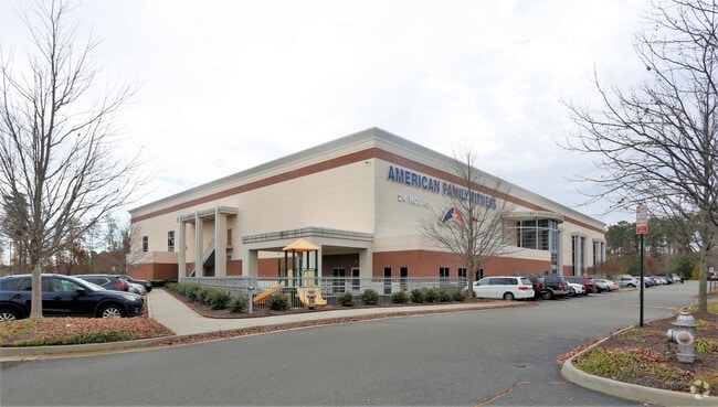
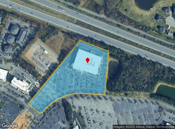
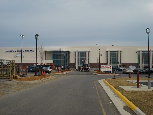
Property Record
11760 W Broad St, Henrico, VA 23233

NEARBY LISTINGS FOR SALE OR LEASE
Property Detail
11760 W Broad St
737-764-0069
00360A0000 0026J; W BROAD ST AC 7.687 PERIPHERAL#3
Recreationalentertainmentgeneral
Henrico
X
Virginia
51085C0290C
7.69 AC
0
Short Pump
2025
Richmond VA
200140
Richmond, VA
118,959 SF
DEMOGRAPHICS near 11760 W Broad St
1 Mile
3 Mile
5 Mile
2024 Total Population
8,798
65,541
133,961
2029 Population
8,920
65,754
134,604
Pop Growth 2024-2029
+ 1.39%
+ 0.32%
+ 0.48%
Average Age
36
39
40
2024 Total Households
3,203
24,192
52,484
HH Growth 2024-2029
+ 1.22%
+ 0.37%
+ 0.55%
Median Household Inc
$130,656
$134,683
$104,682
Avg Household Size
2.70
2.70
2.50
2024 Avg HH Vehicles
2.00
2.00
2.00
Median Home Value
$625,993
$483,161
$426,244
Median Year Built
2004
1996
1991
Nearby Places
Map Layers
Map Styles
 Street
 Aerial
- Restaurants
- Banks
- Shops
- Fitness
- Groceries
PUBLIC TRANSPORTATION
COMMUTER RAIL
DRIVE
WALK
Distance
16 min
9.2 mi
AIRPORT
Richmond International
DRIVE
WALK
Distance
Richmond International
36 min
23.3 mi
Freight Ports
Virginia Port Authority - Richmond
DRIVE
WALK
Distance
Virginia Port Authority - Richmond
34 min
21.6 mi
Nearby Properties
Address
Land Use
TOTAL SIZE
Lot Size
Zoning
Address
Land Use
TOTAL SIZE
Lot Size
Zoning
10,290 SF
56.53 AC
B-3C
Address
Land Use
TOTAL SIZE
Lot Size
Zoning
93.75 AC
M1-INDUS/L
Address
Land Use
TOTAL SIZE
Lot Size
Zoning
632,549 SF
90.12 AC
R-6
Address
Land Use
TOTAL SIZE
Lot Size
Zoning
37.36 AC
R-5C
Address
Land Use
TOTAL SIZE
Lot Size
Zoning
227,483 SF
12.10 AC
M1-INDUS/L
Address
Land Use
TOTAL SIZE
Lot Size
Zoning
112,224 SF
20.53 AC
MIXE
Address
Land Use
TOTAL SIZE
Lot Size
Zoning
57,104 SF
0.02 AC
UMUC
Address
Land Use
TOTAL SIZE
Lot Size
Zoning
403,784 SF
40.74 AC
MIXE
Address
Land Use
TOTAL SIZE
Lot Size
Zoning
417,042 SF
49.96 AC
O-3C
Address
Land Use
TOTAL SIZE
Lot Size
Zoning
3,077 SF
19.89 AC
M1-INDUS/L
Address
Land Use
TOTAL SIZE
Lot Size
Zoning
254,325 SF
60.28 AC
A-1
Address
Land Use
TOTAL SIZE
Lot Size
Zoning
340 SF
23.32 AC
MIXE
Address
Land Use
TOTAL SIZE
Lot Size
Zoning
252,912 SF
28.54 AC
R-6
Address
Land Use
TOTAL SIZE
Lot Size
Zoning
278,084 SF
21.70 AC
R-6C
Address
Land Use
TOTAL SIZE
Lot Size
Zoning
309,156 SF
17.13 AC
R-6
Address
Land Use
TOTAL SIZE
Lot Size
Zoning
306,040 SF
32.24 AC
R-5
Address
Land Use
TOTAL SIZE
Lot Size
Zoning
282,400 SF
18.71 AC
MIXE
Address
Land Use
TOTAL SIZE
Lot Size
Zoning
289,752 SF
24.72 AC
R-5C
Address
Land Use
TOTAL SIZE
Lot Size
Zoning
5.43 AC
UMUC
Address
Land Use
TOTAL SIZE
Lot Size
Zoning
7.98 AC
UMUC
Address
Land Use
TOTAL SIZE
Lot Size
Zoning
138,713 SF
46.53 AC
A-1
Address
Land Use
TOTAL SIZE
Lot Size
Zoning
243,357 SF
32.34 AC
MIXE
Address
Land Use
TOTAL SIZE
Lot Size
Zoning
352,296 SF
23.62 AC
R-5
Address
Land Use
TOTAL SIZE
Lot Size
Zoning
382,944 SF
18.17 AC
M-1
Address
Land Use
TOTAL SIZE
Lot Size
Zoning
326,755 SF
36.20 AC
O-3C
Address
Land Use
TOTAL SIZE
Lot Size
Zoning
5,590 SF
11.54 AC
B-2C
Address
Land Use
TOTAL SIZE
Lot Size
Zoning
271,263 SF
18.81 AC
MIXE
Address
Land Use
TOTAL SIZE
Lot Size
Zoning
329,044 SF
8.09 AC
UMUC
Address
Land Use
TOTAL SIZE
Lot Size
Zoning
156,332 SF
15.27 AC
R-5
Address
Land Use
TOTAL SIZE
Lot Size
Zoning
179,920 SF
16.23 AC
R-5
The World's #1 Commercial Real Estate Marketplace
Connect with us
© 2026 CoStar Group
The information above has been obtained from sources believed reliable. While we do not doubt its accuracy we have not verified it and make no guarantee, warranty or representation about it. It is your responsibility to independently confirm its accuracy and completeness. Any projections, opinions, assumptions, or estimates used are for example only and do not represent the current or future performance of the property. The value of this transaction to you depends on tax and other factors which should be evaluated by your tax, financial, and legal advisors. You and your advisors should conduct a careful, independent investigation of the property to determine to your satisfaction the suitability of the property for your needs.