Property Record
11761 Nc Highway 770, Eden, NC 27288
NEARBY LISTINGS FOR SALE OR LEASE
-
-
View all Eden listings for sale on LoopNet.com
Property Detail
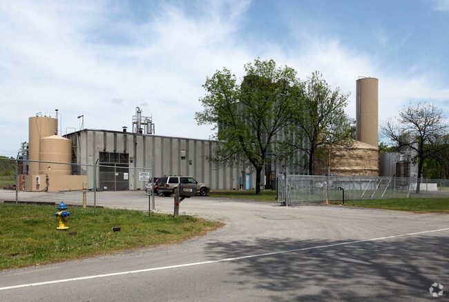
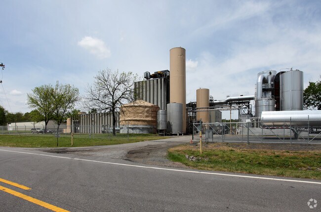
11761 Nc Highway 770
147004
Survey For Rockingham Prime Properties
Manufacturinglight
6.38 AC NC 770 (BERRY HILL RD)
X
Rockingham
51143C0595E
North Carolina
2025
6.38 AC
2025
Rockingham County
040200
Greensboro/Winston-Salem
5,840 SF
Greensboro-High Point, NC
DEMOGRAPHICS near 11761 Nc Highway 770
1 Mile
3 Mile
5 Mile
2024 Total Population
107
4,187
11,651
2029 Population
111
4,311
11,963
Pop Growth 2024-2029
+ 3.74%
+ 2.96%
+ 2.68%
Average Age
44
41
43
2024 Total Households
48
1,745
5,037
HH Growth 2024-2029
+ 4.17%
+ 2.92%
+ 2.62%
Median Household Inc
$39,999
$31,962
$40,962
Avg Household Size
2.20
2.30
2.30
2024 Avg HH Vehicles
2.00
2.00
2.00
Median Home Value
$77,272
$90,432
$115,327
Median Year Built
1974
1957
1971
Nearby Places
Map Layers
Map Styles
 Street
 Aerial
- Restaurants
- Banks
- Shops
- Fitness
- Groceries
PUBLIC TRANSPORTATION
AIRPORT
Piedmont Triad International
DRIVE
WALK
Distance
Piedmont Triad International
67 min
48.4 mi
Nearby Properties
Address
Land Use
TOTAL SIZE
Lot Size
Zoning
Address
Land Use
TOTAL SIZE
Lot Size
Zoning
161,928 SF
22.72 AC
LIGHT INDU
Address
Land Use
TOTAL SIZE
Lot Size
Zoning
478,724 SF
142.07 AC
LIGHT INDU
Address
Land Use
TOTAL SIZE
Lot Size
Zoning
10,100 SF
10.19 AC
RES 12 EDE
Address
Land Use
TOTAL SIZE
Lot Size
Zoning
172,252 SF
17 AC
LIGHT INDU
Address
Land Use
TOTAL SIZE
Lot Size
Zoning
85,306 SF
14.78 AC
LIGHT INDU
Address
Land Use
TOTAL SIZE
Lot Size
Zoning
104,602 SF
35.73 AC
LIGHT INDU
Address
Land Use
TOTAL SIZE
Lot Size
Zoning
140,503 SF
15.65 AC
LIGHT INDU
Address
Land Use
TOTAL SIZE
Lot Size
Zoning
22,196 SF
3.39 AC
RES MIXED
Address
Land Use
TOTAL SIZE
Lot Size
Zoning
6,819 SF
9.65 AC
RES 12 EDE
Address
Land Use
TOTAL SIZE
Lot Size
Zoning
489.82 AC
RES AG COU
Address
Land Use
TOTAL SIZE
Lot Size
Zoning
20,000 SF
14.81 AC
OPEN SPACE
Address
Land Use
TOTAL SIZE
Lot Size
Zoning
15,507 SF
9.13 AC
RES MIXED
Address
Land Use
TOTAL SIZE
Lot Size
Zoning
9,196 SF
1.34 AC
NEIGHBORHO
Address
Land Use
TOTAL SIZE
Lot Size
Zoning
12,432 SF
1.43 AC
RES 12 EDE
Address
Land Use
TOTAL SIZE
Lot Size
Zoning
657.73 AC
RES AG EDE
Address
Land Use
TOTAL SIZE
Lot Size
Zoning
4,912 SF
2.32 AC
RES 12 EDE
Address
Land Use
TOTAL SIZE
Lot Size
Zoning
7,106 SF
0.64 AC
RES 12 EDE
Address
Land Use
TOTAL SIZE
Lot Size
Zoning
5,080 SF
33.80 AC
A-1
Address
Land Use
TOTAL SIZE
Lot Size
Zoning
5,156 SF
2.01 AC
RES 12 EDE
Address
Land Use
TOTAL SIZE
Lot Size
Zoning
123,818 SF
7.04 AC
HEAVY INDU
Address
Land Use
TOTAL SIZE
Lot Size
Zoning
4,896 SF
0.68 AC
RES 20 EDE
Address
Land Use
TOTAL SIZE
Lot Size
Zoning
179.34 AC
LIGHT INDU
Address
Land Use
TOTAL SIZE
Lot Size
Zoning
10,201 SF
0.99 AC
RES MIXED
Address
Land Use
TOTAL SIZE
Lot Size
Zoning
20,808 SF
24.86 AC
HEAVY INDU
Address
Land Use
TOTAL SIZE
Lot Size
Zoning
3,576 SF
4.47 AC
RES AG EDE
Address
Land Use
TOTAL SIZE
Lot Size
Zoning
4,899 SF
0.97 AC
GEN BUS ED
Address
Land Use
TOTAL SIZE
Lot Size
Zoning
112.94 AC
LIGHT INDU
Address
Land Use
TOTAL SIZE
Lot Size
Zoning
25 AC
LIGHT INDU
Address
Land Use
TOTAL SIZE
Lot Size
Zoning
3,114 SF
0.39 AC
RES 12 EDE
The World's #1 Commercial Real Estate Marketplace
Connect with us
© 2026 CoStar Group
The information above has been obtained from sources believed reliable. While we do not doubt its accuracy we have not verified it and make no guarantee, warranty or representation about it. It is your responsibility to independently confirm its accuracy and completeness. Any projections, opinions, assumptions, or estimates used are for example only and do not represent the current or future performance of the property. The value of this transaction to you depends on tax and other factors which should be evaluated by your tax, financial, and legal advisors. You and your advisors should conduct a careful, independent investigation of the property to determine to your satisfaction the suitability of the property for your needs.