Property Record
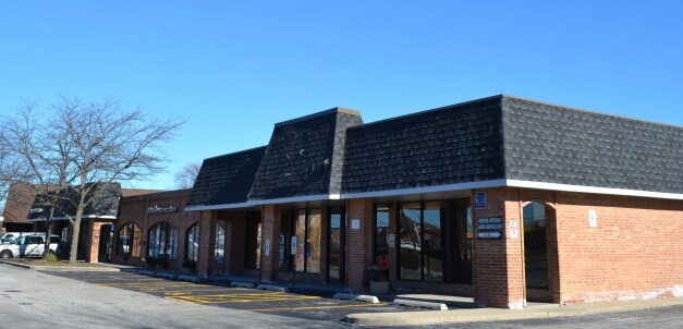
1151 N Arlington Heights Rd, Buffalo Grove, IL 60089


NEARBY LISTINGS FOR SALE OR LEASE
Property Detail
1151 N Arlington Heights Rd
Chicago-Naperville-Elgin, IL-IN-WI
Prudential Realty Resub
15-29-305-002
PRUDENTIAL REALTY RESUB LOT 2
Commercialbuilding
Lake
X
Illinois
17097C0261K
2
2023
2.33 AC
2024
Central North
864516
Chicago
DEMOGRAPHICS near 1151 N Arlington Heights Rd
1 Mile
3 Mile
5 Mile
2024 Total Population
8,895
88,542
220,134
2029 Population
8,784
86,925
216,180
Pop Growth 2024-2029
(1.25%)
(1.83%)
(1.80%)
Average Age
41
41
41
2024 Total Households
3,070
33,010
82,809
HH Growth 2024-2029
(1.34%)
(2.10%)
(2.02%)
Median Household Inc
$143,681
$99,762
$102,477
Avg Household Size
2.80
2.60
2.60
2024 Avg HH Vehicles
2.00
2.00
2.00
Median Home Value
$370,177
$356,593
$361,808
Median Year Built
1977
1981
1979
Nearby Places
Map Layers
Map Styles
 Street
 Aerial
- Restaurants
- Banks
- Shops
- Fitness
- Groceries
PUBLIC TRANSPORTATION
COMMUTER RAIL
Buffalo Grove Station (North Central Service - Northeast Illinois Regional Commuter Railroad (Metra))
DRIVE
WALK
Distance
Buffalo Grove Station (North Central Service - Northeast Illinois Regional Commuter Railroad (Metra))
5 min
2.7 mi
Prairie View Station (North Central Service - Northeast Illinois Regional Commuter Railroad (Metra))
DRIVE
WALK
Distance
Prairie View Station (North Central Service - Northeast Illinois Regional Commuter Railroad (Metra))
7 min
4.2 mi
AIRPORT
Chicago O'Hare International
DRIVE
WALK
Distance
Chicago O'Hare International
29 min
19.4 mi
Chicago Midway International
DRIVE
WALK
Distance
Chicago Midway International
55 min
38.6 mi
Freight Ports
Port Milwaukee
DRIVE
WALK
Distance
Port Milwaukee
80 min
62.7 mi
Nearby Properties
Address
Land Use
TOTAL SIZE
Lot Size
Zoning
Address
Land Use
TOTAL SIZE
Lot Size
Zoning
Address
Land Use
TOTAL SIZE
Lot Size
Zoning
18.40 AC
Address
Land Use
TOTAL SIZE
Lot Size
Zoning
8.21 AC
Address
Land Use
TOTAL SIZE
Lot Size
Zoning
Address
Land Use
TOTAL SIZE
Lot Size
Zoning
622,896 SF
3.94 AC
Address
Land Use
TOTAL SIZE
Lot Size
Zoning
12.58 AC
Address
Land Use
TOTAL SIZE
Lot Size
Zoning
Address
Land Use
TOTAL SIZE
Lot Size
Zoning
Address
Land Use
TOTAL SIZE
Lot Size
Zoning
13.53 AC
Address
Land Use
TOTAL SIZE
Lot Size
Zoning
Address
Land Use
TOTAL SIZE
Lot Size
Zoning
22.16 AC
Address
Land Use
TOTAL SIZE
Lot Size
Zoning
Address
Land Use
TOTAL SIZE
Lot Size
Zoning
214,428 SF
17.29 AC
Address
Land Use
TOTAL SIZE
Lot Size
Zoning
Address
Land Use
TOTAL SIZE
Lot Size
Zoning
15.37 AC
Address
Land Use
TOTAL SIZE
Lot Size
Zoning
197,097 SF
21.80 AC
Address
Land Use
TOTAL SIZE
Lot Size
Zoning
29.76 AC
Address
Land Use
TOTAL SIZE
Lot Size
Zoning
Address
Land Use
TOTAL SIZE
Lot Size
Zoning
9.08 AC
Address
Land Use
TOTAL SIZE
Lot Size
Zoning
10.27 AC
Address
Land Use
TOTAL SIZE
Lot Size
Zoning
Address
Land Use
TOTAL SIZE
Lot Size
Zoning
392,574 SF
25.82 AC
Address
Land Use
TOTAL SIZE
Lot Size
Zoning
102,425 SF
9.38 AC
Address
Land Use
TOTAL SIZE
Lot Size
Zoning
Address
Land Use
TOTAL SIZE
Lot Size
Zoning
12.25 AC
Address
Land Use
TOTAL SIZE
Lot Size
Zoning
Address
Land Use
TOTAL SIZE
Lot Size
Zoning
10.72 AC
Address
Land Use
TOTAL SIZE
Lot Size
Zoning
152,838 SF
10.05 AC
Address
Land Use
TOTAL SIZE
Lot Size
Zoning
4,000 SF
1.41 AC
Address
Land Use
TOTAL SIZE
Lot Size
Zoning
162,375 SF
15.36 AC
The World's #1 Commercial Real Estate Marketplace
Connect with us
© 2025 CoStar Group
The information above has been obtained from sources believed reliable. While we do not doubt its accuracy we have not verified it and make no guarantee, warranty or representation about it. It is your responsibility to independently confirm its accuracy and completeness. Any projections, opinions, assumptions, or estimates used are for example only and do not represent the current or future performance of the property. The value of this transaction to you depends on tax and other factors which should be evaluated by your tax, financial, and legal advisors. You and your advisors should conduct a careful, independent investigation of the property to determine to your satisfaction the suitability of the property for your needs.