Property Record
11782 National Pike, Grantsville, MD 21536

NEARBY LISTINGS FOR SALE OR LEASE
-
-
View all Grantsville listings for sale on LoopNet.com
Property Detail
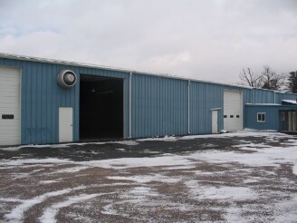
11782 National Pike
Vehiclerentalsvehiclesales
6.34 AC S/S NATIONAL PIKE GRANTSVILLE
X
Garrett
24023C0080D
Maryland
2025
6.34 AC
2025
Maryland West/Hagerstown
000200
Other Market Areas
36,328 SF
03-019217
DEMOGRAPHICS near 11782 National Pike
1 Mile
3 Mile
5 Mile
2024 Total Population
246
1,944
4,328
2029 Population
232
1,830
4,098
Pop Growth 2024-2029
(5.69%)
(5.86%)
(5.31%)
Average Age
44
44
43
2024 Total Households
95
756
1,687
HH Growth 2024-2029
(6.32%)
(6.22%)
(5.63%)
Median Household Inc
$56,249
$56,860
$62,655
Avg Household Size
2.40
2.40
2.40
2024 Avg HH Vehicles
2.00
2.00
2.00
Median Home Value
$167,499
$167,365
$160,141
Median Year Built
1979
1979
1974
Nearby Places
Map Layers
Map Styles
 Street
 Aerial
- Restaurants
- Banks
- Shops
- Fitness
- Groceries
Nearby Properties
Address
Land Use
TOTAL SIZE
Lot Size
Zoning
Address
Land Use
TOTAL SIZE
Lot Size
Zoning
98,889 SF
13.21 AC
Address
Land Use
TOTAL SIZE
Lot Size
Zoning
450 SF
37.66 AC
Address
Land Use
TOTAL SIZE
Lot Size
Zoning
19,760 SF
29.36 AC
Address
Land Use
TOTAL SIZE
Lot Size
Zoning
49,367 SF
3.29 AC
R
Address
Land Use
TOTAL SIZE
Lot Size
Zoning
3,000 SF
371.07 AC
Address
Land Use
TOTAL SIZE
Lot Size
Zoning
6,336 SF
16.50 AC
Address
Land Use
TOTAL SIZE
Lot Size
Zoning
2,984 SF
5.82 AC
Address
Land Use
TOTAL SIZE
Lot Size
Zoning
2,633 SF
10.37 AC
Address
Land Use
TOTAL SIZE
Lot Size
Zoning
10,320 SF
5.15 AC
Address
Land Use
TOTAL SIZE
Lot Size
Zoning
17,428 SF
3.99 AC
Address
Land Use
TOTAL SIZE
Lot Size
Zoning
24,760 SF
6.80 AC
Address
Land Use
TOTAL SIZE
Lot Size
Zoning
52,500 SF
4.61 AC
Address
Land Use
TOTAL SIZE
Lot Size
Zoning
7,952 SF
9.94 AC
Address
Land Use
TOTAL SIZE
Lot Size
Zoning
4,824 SF
3.66 AC
Address
Land Use
TOTAL SIZE
Lot Size
Zoning
27,500 SF
7.17 AC
Address
Land Use
TOTAL SIZE
Lot Size
Zoning
8,000 SF
41.97 AC
Address
Land Use
TOTAL SIZE
Lot Size
Zoning
9,230 SF
0.67 AC
C
Address
Land Use
TOTAL SIZE
Lot Size
Zoning
4,192 SF
0.84 AC
Address
Land Use
TOTAL SIZE
Lot Size
Zoning
43,750 SF
2.32 AC
Address
Land Use
TOTAL SIZE
Lot Size
Zoning
80,356 SF
3.22 AC
C
Address
Land Use
TOTAL SIZE
Lot Size
Zoning
5,597 SF
0.58 AC
Address
Land Use
TOTAL SIZE
Lot Size
Zoning
4,079 SF
1.23 AC
R
Address
Land Use
TOTAL SIZE
Lot Size
Zoning
12,412 SF
3.75 AC
Address
Land Use
TOTAL SIZE
Lot Size
Zoning
8,500 SF
4.72 AC
Address
Land Use
TOTAL SIZE
Lot Size
Zoning
10,238 SF
4.15 AC
Address
Land Use
TOTAL SIZE
Lot Size
Zoning
6,383 SF
1.07 AC
Address
Land Use
TOTAL SIZE
Lot Size
Zoning
13,979 SF
3.11 AC
Address
Land Use
TOTAL SIZE
Lot Size
Zoning
8,000 SF
3.77 AC
Address
Land Use
TOTAL SIZE
Lot Size
Zoning
2,496 SF
5.38 AC
The World's #1 Commercial Real Estate Marketplace
Connect with us
© 2026 CoStar Group
The information above has been obtained from sources believed reliable. While we do not doubt its accuracy we have not verified it and make no guarantee, warranty or representation about it. It is your responsibility to independently confirm its accuracy and completeness. Any projections, opinions, assumptions, or estimates used are for example only and do not represent the current or future performance of the property. The value of this transaction to you depends on tax and other factors which should be evaluated by your tax, financial, and legal advisors. You and your advisors should conduct a careful, independent investigation of the property to determine to your satisfaction the suitability of the property for your needs.