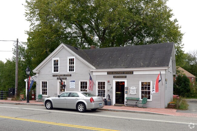
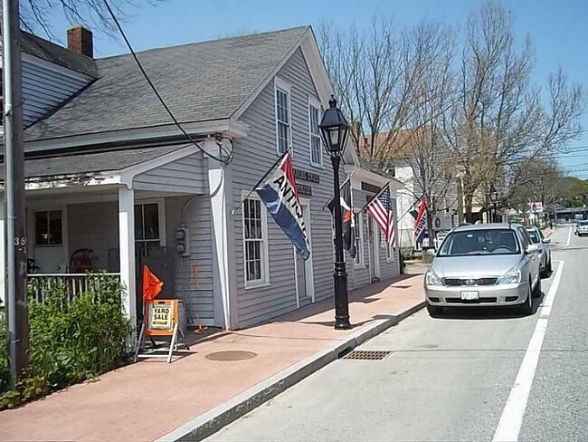
Property Record
1178A Putnam Pike, Chepachet, RI 02814

Property Detail
1178A Putnam Pike
Commercialbuilding
PROVIDENCE
3
Rhode Island
B and X Area of moderate flood hazard, usually the area between the limits of the 100-year and 500-year floods.
0.11 AC
2025
Burrillville/Glocester
2025
Providence
013101
Providence-Warwick, RI-MA
2,160 SF
GLOC-000000-000000-000010A-000063
NEARBY LISTINGS FOR SALE OR LEASE
-
-
View all Chepachet listings for sale on LoopNet.com
DEMOGRAPHICS near 1178A Putnam Pike
1 mile
3 mile
5 mile
2025 Total Population
1,078
8,999
24,808
2030 Population
1,125
9,437
26,011
Pop Growth 2025-2030
+ 4.36%
+ 4.87%
+ 4.85%
Average Age
44
44
44
2025 Total Households
429
3,461
9,639
HH Growth 2025-2030
+ 4.66%
+ 4.91%
+ 4.87%
Median Household Inc
$105,048
$107,053
$106,190
Avg Household Size
2.50
2.60
2.50
2025 Avg HH Vehicles
2.00
2.00
2.00
Median Home Value
$408,889
$405,757
$418,535
Median Year Built
1972
1975
1971
Nearby Places
Map Layers
Map Styles
 Street
 Aerial
Layers
 Traffic
 Biking
Places
Listings with unknown addresses are not visible on the map
- Restaurants
- Banks
- Shops
- Fitness
- Groceries
PUBLIC TRANSPORTATION
AIRPORT
Rhode Island Tf Green International
Drive
Walk
Distance
Rhode Island Tf Green International
36 min
23.0 mi
Worcester Regional
Drive
Walk
Distance
Worcester Regional
51 min
35.9 mi
Freight Ports
Port of Davisville, RI
Drive
Walk
Distance
Port of Davisville, RI
48 min
32.3 mi
SALE & LEASE HISTORY
LISTING DATE
SALE/LEASE

Sep 23, 2016
For Sale
Apr 27, 2017
For Sale
Nearby Properties
Address
Land Use
TOTAL SIZE
Lot Size
Zoning
Address
Land Use
TOTAL SIZE
Lot Size
Zoning
64.77 AC
GI
Address
Land Use
TOTAL SIZE
Lot Size
Zoning
192.38 AC
R20
Address
Land Use
TOTAL SIZE
Lot Size
Zoning
42,504 SF
10.35 AC
R40
Address
Land Use
TOTAL SIZE
Lot Size
Zoning
151,584 SF
7.61 AC
GI
Address
Land Use
TOTAL SIZE
Lot Size
Zoning
173.57 AC
20
Address
Land Use
TOTAL SIZE
Lot Size
Zoning
44.50 AC
F5
Address
Land Use
TOTAL SIZE
Lot Size
Zoning
43,999 SF
7.79 AC
GI
Address
Land Use
TOTAL SIZE
Lot Size
Zoning
16,711 SF
2.06 AC
40
Address
Land Use
TOTAL SIZE
Lot Size
Zoning
14,239 SF
186.15 AC
R40
Address
Land Use
TOTAL SIZE
Lot Size
Zoning
16.05 AC
80
Address
Land Use
TOTAL SIZE
Lot Size
Zoning
29,668 SF
1.18 AC
GI
Address
Land Use
TOTAL SIZE
Lot Size
Zoning
52,200 SF
3.44 AC
GI
Address
Land Use
TOTAL SIZE
Lot Size
Zoning
40,767 SF
32.40 AC
R40
Address
Land Use
TOTAL SIZE
Lot Size
Zoning
25,950 SF
4.99 AC
40
Address
Land Use
TOTAL SIZE
Lot Size
Zoning
68.30 AC
GI
Address
Land Use
TOTAL SIZE
Lot Size
Zoning
8.76 AC
80
Address
Land Use
TOTAL SIZE
Lot Size
Zoning
1,390 SF
96 AC
20
Address
Land Use
TOTAL SIZE
Lot Size
Zoning
10.22 AC
1
Address
Land Use
TOTAL SIZE
Lot Size
Zoning
32.18 AC
30
Address
Land Use
TOTAL SIZE
Lot Size
Zoning
32,840 SF
1.84 AC
GI
Address
Land Use
TOTAL SIZE
Lot Size
Zoning
1,936 SF
36.04 AC
20
Address
Land Use
TOTAL SIZE
Lot Size
Zoning
2.03 AC
3
Address
Land Use
TOTAL SIZE
Lot Size
Zoning
42.69 AC
GI
Address
Land Use
TOTAL SIZE
Lot Size
Zoning
2.75 AC
2
Address
Land Use
TOTAL SIZE
Lot Size
Zoning
8,054 SF
7.16 AC
20
Address
Land Use
TOTAL SIZE
Lot Size
Zoning
2.88 AC
80
Address
Land Use
TOTAL SIZE
Lot Size
Zoning
37.64 AC
GI
Address
Land Use
TOTAL SIZE
Lot Size
Zoning
2,160 SF
136.57 AC
20
Address
Land Use
TOTAL SIZE
Lot Size
Zoning
4,097 SF
0.87 AC
80
Address
Land Use
TOTAL SIZE
Lot Size
Zoning
12,960 SF
3.87 AC
GI
The World's #1 Commercial Real Estate Marketplace
Connect with us
© 2026 CoStar Group
The information above has been obtained from sources believed reliable. While we do not doubt its accuracy we have not verified it and make no guarantee, warranty or representation about it. It is your responsibility to independently confirm its accuracy and completeness. Any projections, opinions, assumptions, or estimates used are for example only and do not represent the current or future performance of the property. The value of this transaction to you depends on tax and other factors which should be evaluated by your tax, financial, and legal advisors. You and your advisors should conduct a careful, independent investigation of the property to determine to your satisfaction the suitability of the property for your needs.