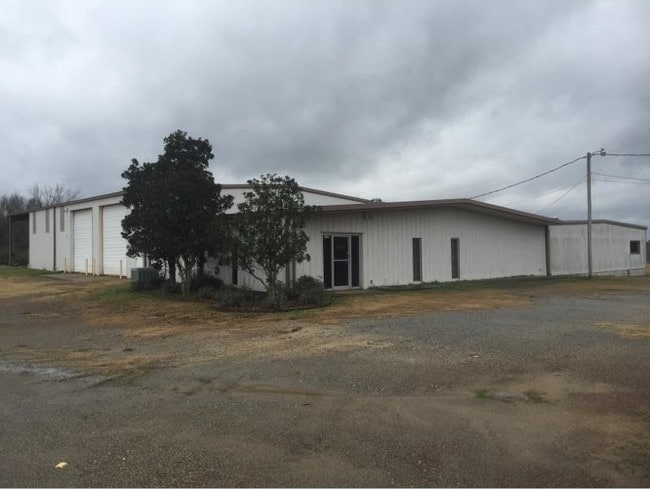
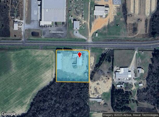
Property Record
1179 Us Highway 280 W, Cordele, GA 31015
NEARBY LISTINGS FOR SALE OR LEASE
-
-
View all Cordele listings for lease on LoopNet.com
Property Detail
1179 Us Highway 280 W
Cordele, GA
Jim C019
019-005
LL 167 D-10
Officebuilding
Crisp
X
Georgia
13081C0130B
167
2024
3.96 AC
2025
Georgia South Area
010201
Other Market Areas
9,588 SF
DEMOGRAPHICS near 1179 Us Highway 280 W
1 Mile
3 Mile
5 Mile
2024 Total Population
46
10,549
13,530
2029 Population
46
10,319
13,171
Pop Growth 2024-2029
0.00%
(2.18%)
(2.65%)
Average Age
46
39
39
2024 Total Households
20
4,257
5,508
HH Growth 2024-2029
0.00%
(1.97%)
(2.47%)
Median Household Inc
$67,500
$34,125
$36,270
Avg Household Size
2.20
2.40
2.40
2024 Avg HH Vehicles
2.00
2.00
2.00
Median Home Value
$274,999
$77,815
$87,482
Median Year Built
1992
1979
1979
Nearby Places
Map Layers
Map Styles
 Street
 Aerial
- Restaurants
- Banks
- Shops
- Fitness
- Groceries
SALE & LEASE HISTORY
LISTING DATE
SALE/LEASE

Mar 20, 2017
For Lease
Nearby Properties
Address
Land Use
TOTAL SIZE
Lot Size
Zoning
Address
Land Use
TOTAL SIZE
Lot Size
Zoning
661,934 SF
298.04 AC
INDUSTRIAL
Address
Land Use
TOTAL SIZE
Lot Size
Zoning
2.94 AC
INDUSTRIAL
Address
Land Use
TOTAL SIZE
Lot Size
Zoning
9.80 AC
RESIDENTIA
Address
Land Use
TOTAL SIZE
Lot Size
Zoning
113,502 SF
7.82 AC
COMMERCIAL
Address
Land Use
TOTAL SIZE
Lot Size
Zoning
45,000 SF
0.34 AC
COMMERCIAL
Address
Land Use
TOTAL SIZE
Lot Size
Zoning
11.77 AC
RESIDENTIA
Address
Land Use
TOTAL SIZE
Lot Size
Zoning
26,100 SF
20.59 AC
INDUSTRIAL
Address
Land Use
TOTAL SIZE
Lot Size
Zoning
15,875 SF
96.92 AC
Address
Land Use
TOTAL SIZE
Lot Size
Zoning
23,084 SF
4.18 AC
RESIDENTIA
Address
Land Use
TOTAL SIZE
Lot Size
Zoning
2,500 SF
44.50 AC
Address
Land Use
TOTAL SIZE
Lot Size
Zoning
14,466 SF
1.74 AC
COMMERCIAL
Address
Land Use
TOTAL SIZE
Lot Size
Zoning
102,700 SF
9.29 AC
RURAL
Address
Land Use
TOTAL SIZE
Lot Size
Zoning
11.11 AC
INDUSTRIAL
Address
Land Use
TOTAL SIZE
Lot Size
Zoning
16,588 SF
2.63 AC
COMMERCIAL
Address
Land Use
TOTAL SIZE
Lot Size
Zoning
43,092 SF
0.69 AC
RESIDENTIA
Address
Land Use
TOTAL SIZE
Lot Size
Zoning
167.82 AC
COMMERCIAL
Address
Land Use
TOTAL SIZE
Lot Size
Zoning
37,778 SF
12.23 AC
COMMERCIAL
Address
Land Use
TOTAL SIZE
Lot Size
Zoning
99.28 AC
RURAL
Address
Land Use
TOTAL SIZE
Lot Size
Zoning
15,000 SF
30 AC
COMMERCIAL
Address
Land Use
TOTAL SIZE
Lot Size
Zoning
37,944 SF
5.51 AC
COMMERCIAL
Address
Land Use
TOTAL SIZE
Lot Size
Zoning
21.70 AC
RURAL
Address
Land Use
TOTAL SIZE
Lot Size
Zoning
5,297 SF
2.94 AC
RESIDENTIA
Address
Land Use
TOTAL SIZE
Lot Size
Zoning
72,704 SF
3.15 AC
COMMERCIAL
Address
Land Use
TOTAL SIZE
Lot Size
Zoning
330.64 AC
RURAL
Address
Land Use
TOTAL SIZE
Lot Size
Zoning
332.41 AC
RURAL
Address
Land Use
TOTAL SIZE
Lot Size
Zoning
6,494 SF
0.27 AC
COMMERCIAL
Address
Land Use
TOTAL SIZE
Lot Size
Zoning
10,338 SF
0.82 AC
RESIDENTIA
Address
Land Use
TOTAL SIZE
Lot Size
Zoning
1,992 SF
1.24 AC
RESIDENTIA
Address
Land Use
TOTAL SIZE
Lot Size
Zoning
10,044 SF
2.45 AC
COMMERCIAL
Address
Land Use
TOTAL SIZE
Lot Size
Zoning
27,770 SF
3.68 AC
RESIDENTIA
The World's #1 Commercial Real Estate Marketplace
Connect with us
© 2025 CoStar Group
The information above has been obtained from sources believed reliable. While we do not doubt its accuracy we have not verified it and make no guarantee, warranty or representation about it. It is your responsibility to independently confirm its accuracy and completeness. Any projections, opinions, assumptions, or estimates used are for example only and do not represent the current or future performance of the property. The value of this transaction to you depends on tax and other factors which should be evaluated by your tax, financial, and legal advisors. You and your advisors should conduct a careful, independent investigation of the property to determine to your satisfaction the suitability of the property for your needs.