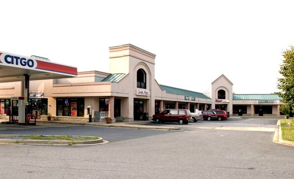
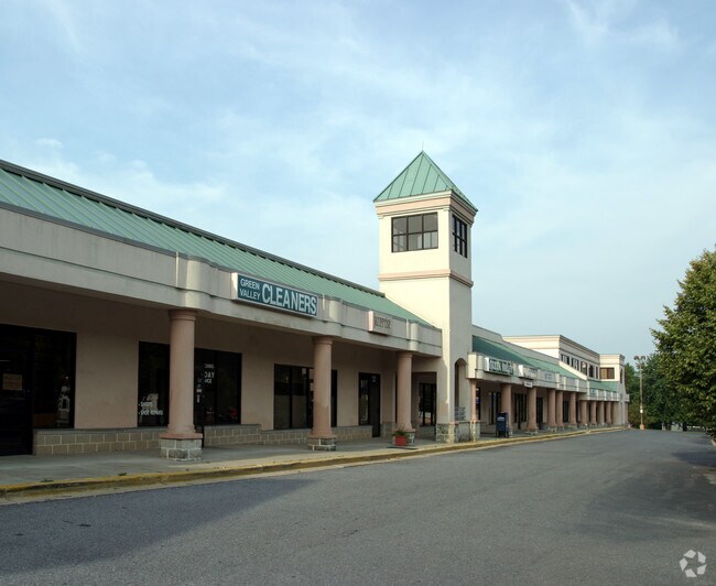
Property Record
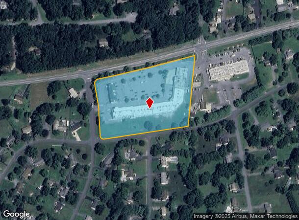
11791 Fingerboard Rd, Monrovia, MD 21770
NEARBY LISTINGS FOR SALE OR LEASE
Property Detail
11791 Fingerboard Rd
Washington-Arlington-Alexandria, DC-VA-MD-WV
Green Valley
09-235183
5.2289 ACRES LYNN BURKE ROAD GREEN VALLEY
Officebuilding
Frederick
X
Maryland
24021C0459E
1
2024
5.22 AC
2025
Frederick
752102
Washington, DC
47,170 SF
DEMOGRAPHICS near 11791 Fingerboard Rd
1 Mile
3 Mile
5 Mile
2024 Total Population
2,085
16,220
48,894
2029 Population
2,344
18,342
55,074
Pop Growth 2024-2029
+ 12.42%
+ 13.08%
+ 12.64%
Average Age
42
41
39
2024 Total Households
719
5,445
16,041
HH Growth 2024-2029
+ 12.93%
+ 13.43%
+ 12.91%
Median Household Inc
$138,025
$152,227
$143,442
Avg Household Size
2.90
3.00
3.00
2024 Avg HH Vehicles
3.00
3.00
2.00
Median Home Value
$489,528
$567,033
$517,776
Median Year Built
1982
1986
1995
Nearby Places
Map Layers
Map Styles
 Street
 Aerial
- Restaurants
- Banks
- Shops
- Fitness
- Groceries
SALE & LEASE HISTORY
LISTING DATE
SALE/LEASE

Sep 24, 2016
For Lease
Nearby Properties
Address
Land Use
TOTAL SIZE
Lot Size
Zoning
Address
Land Use
TOTAL SIZE
Lot Size
Zoning
1,027,347 SF
123.95 AC
GI
Address
Land Use
TOTAL SIZE
Lot Size
Zoning
65,000 SF
63.89 AC
A
Address
Land Use
TOTAL SIZE
Lot Size
Zoning
133,042 SF
53.90 AC
IE
Address
Land Use
TOTAL SIZE
Lot Size
Zoning
26,912 SF
17.65 AC
LI
Address
Land Use
TOTAL SIZE
Lot Size
Zoning
25,600 SF
36 AC
A
Address
Land Use
TOTAL SIZE
Lot Size
Zoning
2,496 SF
125.75 AC
LI
Address
Land Use
TOTAL SIZE
Lot Size
Zoning
58,380 SF
4.77 AC
GI
Address
Land Use
TOTAL SIZE
Lot Size
Zoning
41,076 SF
3.56 AC
LI
Address
Land Use
TOTAL SIZE
Lot Size
Zoning
35,314 SF
19.44 AC
A
Address
Land Use
TOTAL SIZE
Lot Size
Zoning
51,998 SF
29.89 AC
R1
Address
Land Use
TOTAL SIZE
Lot Size
Zoning
31,697 SF
4.42 AC
GC
Address
Land Use
TOTAL SIZE
Lot Size
Zoning
37,878 SF
5.21 AC
GC
Address
Land Use
TOTAL SIZE
Lot Size
Zoning
29,157 SF
12.15 AC
A
Address
Land Use
TOTAL SIZE
Lot Size
Zoning
36,914 SF
4.74 AC
GC
Address
Land Use
TOTAL SIZE
Lot Size
Zoning
9,703 SF
42.48 AC
A
Address
Land Use
TOTAL SIZE
Lot Size
Zoning
47,880 SF
12.68 AC
LI
Address
Land Use
TOTAL SIZE
Lot Size
Zoning
18,638 SF
206.49 AC
A
Address
Land Use
TOTAL SIZE
Lot Size
Zoning
28,022 SF
3.99 AC
LI
Address
Land Use
TOTAL SIZE
Lot Size
Zoning
15,264 SF
6.96 AC
AR
Address
Land Use
TOTAL SIZE
Lot Size
Zoning
30,804 SF
2.31 AC
Address
Land Use
TOTAL SIZE
Lot Size
Zoning
9 SF
22.53 AC
LI
Address
Land Use
TOTAL SIZE
Lot Size
Zoning
15.03 AC
GC
Address
Land Use
TOTAL SIZE
Lot Size
Zoning
14,428 SF
2.48 AC
GC
Address
Land Use
TOTAL SIZE
Lot Size
Zoning
1,776 SF
25 AC
LI
Address
Land Use
TOTAL SIZE
Lot Size
Zoning
1,840 SF
130.93 AC
A
Address
Land Use
TOTAL SIZE
Lot Size
Zoning
16,894 SF
3.88 AC
LI
Address
Land Use
TOTAL SIZE
Lot Size
Zoning
2,040 SF
113.91 AC
AR
Address
Land Use
TOTAL SIZE
Lot Size
Zoning
912 SF
28.28 AC
GC
Address
Land Use
TOTAL SIZE
Lot Size
Zoning
11.27 AC
GC
The World's #1 Commercial Real Estate Marketplace
Connect with us
© 2026 CoStar Group
The information above has been obtained from sources believed reliable. While we do not doubt its accuracy we have not verified it and make no guarantee, warranty or representation about it. It is your responsibility to independently confirm its accuracy and completeness. Any projections, opinions, assumptions, or estimates used are for example only and do not represent the current or future performance of the property. The value of this transaction to you depends on tax and other factors which should be evaluated by your tax, financial, and legal advisors. You and your advisors should conduct a careful, independent investigation of the property to determine to your satisfaction the suitability of the property for your needs.