Property Record
118 2Nd St, Elko, NV 89801
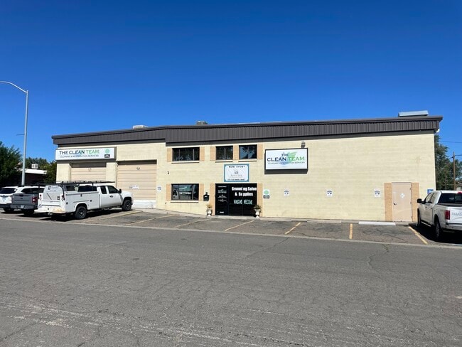

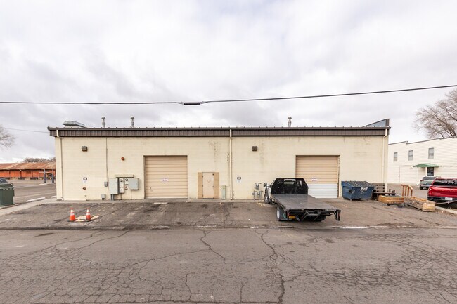
Property Detail
118 2Nd St
001-334-006
118 2ND ST
Commercialnec
Elko
ZLI
Nevada
AE The base floodplain where base flood elevations are provided. AE Zones are now used on new format FIRMs instead of A1-A30 Zones.
13-16
2024
0.23 AC
2025
Carson City/Nevada Area
951000
Other Market Areas
8,100 SF
Elko, NV
NEARBY LISTINGS FOR SALE OR LEASE
DEMOGRAPHICS near 118 2Nd St
1 mile
3 mile
5 mile
2025 Total Population
9,868
24,325
25,678
2030 Population
10,066
24,781
26,168
Pop Growth 2025-2030
+ 2.01%
+ 1.87%
+ 1.91%
Average Age
36
36
36
2025 Total Households
4,035
9,276
9,777
HH Growth 2025-2030
+ 1.98%
+ 1.91%
+ 1.94%
Median Household Inc
$63,269
$78,691
$79,624
Avg Household Size
2.40
2.60
2.60
2025 Avg HH Vehicles
2.00
2.00
2.00
Median Home Value
$257,739
$300,615
$295,154
Median Year Built
1974
1986
1986
Nearby Places
Map Layers
Map Styles
 Street
 Aerial
Transit
 Traffic
 Biking
Places
Listings with unknown addresses are not visible on the map
- Restaurants
- Banks
- Shops
- Fitness
- Groceries
PUBLIC TRANSPORTATION
COMMUTER RAIL
Drive
Walk
Distance
3 min
20 min
1.0 mi
SALE & LEASE HISTORY
LISTING DATE
SALE/LEASE

Oct 17, 2022
For Sale
Jan 16, 2025
For Sale
Nearby Properties
Address
Land Use
TOTAL SIZE
Lot Size
Zoning
Address
Land Use
TOTAL SIZE
Lot Size
Zoning
120,451 SF
45 AC
ZPC
Address
Land Use
TOTAL SIZE
Lot Size
Zoning
47,730 SF
479.29 AC
MULT
Address
Land Use
TOTAL SIZE
Lot Size
Zoning
215,373 SF
14.03 AC
ZPQP
Address
Land Use
TOTAL SIZE
Lot Size
Zoning
222,607 SF
10.39 AC
ZC
Address
Land Use
TOTAL SIZE
Lot Size
Zoning
14.71 AC
ZLI
Address
Land Use
TOTAL SIZE
Lot Size
Zoning
107,153 SF
53.50 AC
ZPQP
Address
Land Use
TOTAL SIZE
Lot Size
Zoning
184,595 SF
10.79 AC
ZR
Address
Land Use
TOTAL SIZE
Lot Size
Zoning
212,789 SF
22.72 AC
ZC
Address
Land Use
TOTAL SIZE
Lot Size
Zoning
23,552 SF
78.93 AC
MULT
Address
Land Use
TOTAL SIZE
Lot Size
Zoning
146,208 SF
36.18 AC
MULT
Address
Land Use
TOTAL SIZE
Lot Size
Zoning
89,473 SF
10.47 AC
ZC
Address
Land Use
TOTAL SIZE
Lot Size
Zoning
1,253 SF
4 AC
ZR
Address
Land Use
TOTAL SIZE
Lot Size
Zoning
105,625 SF
11.18 AC
ZC
Address
Land Use
TOTAL SIZE
Lot Size
Zoning
57,884 SF
1.89 AC
ZC
Address
Land Use
TOTAL SIZE
Lot Size
Zoning
54,982 SF
2.17 AC
ZC
Address
Land Use
TOTAL SIZE
Lot Size
Zoning
53,073 SF
2.32 AC
ZC
Address
Land Use
TOTAL SIZE
Lot Size
Zoning
3,234 SF
5.38 AC
ZC
Address
Land Use
TOTAL SIZE
Lot Size
Zoning
59,525 SF
5.91 AC
ZC
Address
Land Use
TOTAL SIZE
Lot Size
Zoning
166,621 SF
1.40 AC
ZC
Address
Land Use
TOTAL SIZE
Lot Size
Zoning
29,193 SF
3.47 AC
ZPQP
Address
Land Use
TOTAL SIZE
Lot Size
Zoning
43,470 SF
1.82 AC
ZC
Address
Land Use
TOTAL SIZE
Lot Size
Zoning
57,628 SF
2.79 AC
ZC
Address
Land Use
TOTAL SIZE
Lot Size
Zoning
53,002 SF
3.11 AC
ZC
Address
Land Use
TOTAL SIZE
Lot Size
Zoning
96,349 SF
6.49 AC
ZC
Address
Land Use
TOTAL SIZE
Lot Size
Zoning
49,124 SF
1.50 AC
ZC
Address
Land Use
TOTAL SIZE
Lot Size
Zoning
32,520 SF
2.29 AC
ZLI
Address
Land Use
TOTAL SIZE
Lot Size
Zoning
36,897 SF
2.57 AC
ZPQP
Address
Land Use
TOTAL SIZE
Lot Size
Zoning
36,717 SF
3.49 AC
ZC
Address
Land Use
TOTAL SIZE
Lot Size
Zoning
98,533 SF
6.66 AC
MULT
Address
Land Use
TOTAL SIZE
Lot Size
Zoning
79,455 SF
9.99 AC
ZC
The World's #1 Commercial Real Estate Marketplace
Connect with us
© 2026 CoStar Group
The information above has been obtained from sources believed reliable. While we do not doubt its accuracy we have not verified it and make no guarantee, warranty or representation about it. It is your responsibility to independently confirm its accuracy and completeness. Any projections, opinions, assumptions, or estimates used are for example only and do not represent the current or future performance of the property. The value of this transaction to you depends on tax and other factors which should be evaluated by your tax, financial, and legal advisors. You and your advisors should conduct a careful, independent investigation of the property to determine to your satisfaction the suitability of the property for your needs.