Property Record
118 E Lehigh Ave, Pontiac, MI 48340
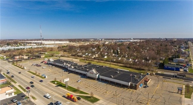
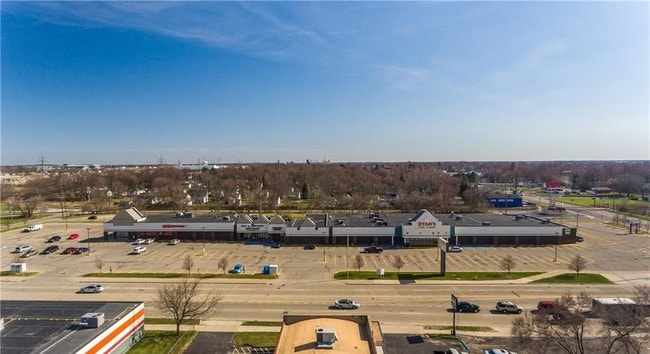

Property Detail
118 E Lehigh Ave
14-17-201-031
T3N, R10E, SEC 17 DUPONT HEIGHTS SUB LOTS 1 TO 7 INCL EXC W 30 FT OF EACH, ALSO EXC N 27 FT OF E 90 FT OF LOT 1, ALSO ALL OF LOTS 444 TO 460 INCL, ALSO LOTS 481 TO 497 INCL, ALSO 1/2 OF VAC ALLEYS ADJ THEREOF, ALSO THAT PART OF 1/2 OF VAC LEHIGH AVE
Regionalshoppingcenterormallwithanchorstore
OAKLAND
BI
Michigan
B and X Area of moderate flood hazard, usually the area between the limits of the 100-year and 500-year floods.
1
2024
5.18 AC
2025
Pontiac
141400
Detroit
53,322 SF
Detroit-Warren-Dearborn, MI
NEARBY LISTINGS FOR SALE OR LEASE
DEMOGRAPHICS near 118 E Lehigh Ave
1 mile
3 mile
5 mile
2025 Total Population
10,518
60,072
164,397
2030 Population
10,715
61,666
169,655
Pop Growth 2025-2030
+ 1.87%
+ 2.65%
+ 3.20%
Average Age
37
38
40
2025 Total Households
4,021
24,174
67,576
HH Growth 2025-2030
+ 1.99%
+ 2.73%
+ 3.27%
Median Household Inc
$47,245
$53,322
$63,556
Avg Household Size
2.50
2.40
2.30
2025 Avg HH Vehicles
1.00
2.00
2.00
Median Home Value
$124,912
$158,928
$222,463
Median Year Built
1958
1964
1971
Nearby Places
Map Layers
Map Styles
 Street
 Aerial
Layers
 Traffic
 Biking
Places
Listings with unknown addresses are not visible on the map
- Restaurants
- Banks
- Shops
- Fitness
- Groceries
PUBLIC TRANSPORTATION
COMMUTER RAIL
Pontiac Amtrak Station (Wolverine - Amtrak)
Drive
Walk
Distance
Pontiac Amtrak Station (Wolverine - Amtrak)
8 min
3.3 mi
Freight Ports
Port of Toledo
Drive
Walk
Distance
Port of Toledo
113 min
85.9 mi
SALE & LEASE HISTORY
LISTING DATE
SALE/LEASE

May 22, 2018
For Lease
Jun 13, 2018
For Sale
Nearby Properties
Address
Land Use
TOTAL SIZE
Lot Size
Zoning
Address
Land Use
TOTAL SIZE
Lot Size
Zoning
1,421,000 SF
170.30 AC
B2
Address
Land Use
TOTAL SIZE
Lot Size
Zoning
715,400 SF
Address
Land Use
TOTAL SIZE
Lot Size
Zoning
316,358 SF
20.89 AC
P
Address
Land Use
TOTAL SIZE
Lot Size
Zoning
527,000 SF
36.03 AC
Address
Land Use
TOTAL SIZE
Lot Size
Zoning
420,858 SF
65.07 AC
Address
Land Use
TOTAL SIZE
Lot Size
Zoning
430,338 SF
46.09 AC
Address
Land Use
TOTAL SIZE
Lot Size
Zoning
1,771,589 SF
96.73 AC
Address
Land Use
TOTAL SIZE
Lot Size
Zoning
247,500 SF
Address
Land Use
TOTAL SIZE
Lot Size
Zoning
246,150 SF
26.64 AC
TR
Address
Land Use
TOTAL SIZE
Lot Size
Zoning
430,338 SF
43.22 AC
Address
Land Use
TOTAL SIZE
Lot Size
Zoning
280,000 SF
Address
Land Use
TOTAL SIZE
Lot Size
Zoning
213,112 SF
12.17 AC
I1
Address
Land Use
TOTAL SIZE
Lot Size
Zoning
144,349 SF
12.42 AC
SP
Address
Land Use
TOTAL SIZE
Lot Size
Zoning
455,045 SF
23.47 AC
I1
Address
Land Use
TOTAL SIZE
Lot Size
Zoning
172,076 SF
11.18 AC
Address
Land Use
TOTAL SIZE
Lot Size
Zoning
232,860 SF
28.30 AC
I1
Address
Land Use
TOTAL SIZE
Lot Size
Zoning
186,242 SF
Address
Land Use
TOTAL SIZE
Lot Size
Zoning
173,974 SF
31.37 AC
TR
Address
Land Use
TOTAL SIZE
Lot Size
Zoning
174,019 SF
9.66 AC
Address
Land Use
TOTAL SIZE
Lot Size
Zoning
148,825 SF
Address
Land Use
TOTAL SIZE
Lot Size
Zoning
171,242 SF
11.86 AC
Address
Land Use
TOTAL SIZE
Lot Size
Zoning
107,376 SF
10.18 AC
Address
Land Use
TOTAL SIZE
Lot Size
Zoning
137,086 SF
9.29 AC
I1
Address
Land Use
TOTAL SIZE
Lot Size
Zoning
102,379 SF
28.20 AC
Address
Land Use
TOTAL SIZE
Lot Size
Zoning
245,436 SF
39.08 AC
Address
Land Use
TOTAL SIZE
Lot Size
Zoning
142,858 SF
Address
Land Use
TOTAL SIZE
Lot Size
Zoning
136,061 SF
14.64 AC
Address
Land Use
TOTAL SIZE
Lot Size
Zoning
218,870 SF
23.21 AC
Address
Land Use
TOTAL SIZE
Lot Size
Zoning
124,104 SF
Address
Land Use
TOTAL SIZE
Lot Size
Zoning
79,263 SF
22.27 AC
The World's #1 Commercial Real Estate Marketplace
Connect with us
© 2026 CoStar Group
The information above has been obtained from sources believed reliable. While we do not doubt its accuracy we have not verified it and make no guarantee, warranty or representation about it. It is your responsibility to independently confirm its accuracy and completeness. Any projections, opinions, assumptions, or estimates used are for example only and do not represent the current or future performance of the property. The value of this transaction to you depends on tax and other factors which should be evaluated by your tax, financial, and legal advisors. You and your advisors should conduct a careful, independent investigation of the property to determine to your satisfaction the suitability of the property for your needs.