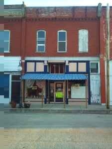
Property Record
118 E Main St, Ash Grove, MO 65604
NEARBY LISTINGS FOR SALE OR LEASE
Property Detail
118 E Main St
Springfield, MO
Walker & Bentleys
06-21-310-016
WALKER & BENTLEYS ADD W 24.6 FT M/L LOT 1 & ALL LOT 2 BLK F
Commercialnec
Greene
X
Missouri
29109C0125D
1-2
2025
0.14 AC
2025
Outlying Greene County
005001
Springfield
8,988 SF
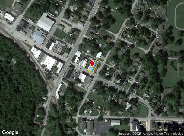
DEMOGRAPHICS near 118 E Main St
1 Mile
3 Mile
5 Mile
2024 Total Population
1,591
2,141
3,148
2029 Population
1,644
2,213
3,250
Pop Growth 2024-2029
+ 3.33%
+ 3.36%
+ 3.24%
Average Age
42
42
42
2024 Total Households
626
842
1,236
HH Growth 2024-2029
+ 3.51%
+ 3.56%
+ 3.40%
Median Household Inc
$56,414
$56,461
$57,770
Avg Household Size
2.50
2.50
2.50
2024 Avg HH Vehicles
2.00
2.00
2.00
Median Home Value
$187,313
$186,463
$190,658
Median Year Built
1969
1969
1973
Nearby Places
Map Layers
Map Styles
 Street
 Aerial
- Restaurants
- Banks
- Shops
- Fitness
- Groceries
PUBLIC TRANSPORTATION
AIRPORT
Springfield-Branson Ntl
DRIVE
WALK
Distance
Springfield-Branson Ntl
25 min
15.0 mi
Nearby Properties
Address
Land Use
TOTAL SIZE
Lot Size
Zoning
Address
Land Use
TOTAL SIZE
Lot Size
Zoning
47,273 SF
23 AC
INC
Address
Land Use
TOTAL SIZE
Lot Size
Zoning
9,012 SF
1.32 AC
INC
Address
Land Use
TOTAL SIZE
Lot Size
Zoning
8,960 SF
1.78 AC
INC
Address
Land Use
TOTAL SIZE
Lot Size
Zoning
35,527 SF
0.64 AC
INC
Address
Land Use
TOTAL SIZE
Lot Size
Zoning
11,060 SF
0.71 AC
INC
Address
Land Use
TOTAL SIZE
Lot Size
Zoning
10,625 SF
0.68 AC
INC
Address
Land Use
TOTAL SIZE
Lot Size
Zoning
7,022 SF
1.35 AC
INC
Address
Land Use
TOTAL SIZE
Lot Size
Zoning
16,302 SF
1.24 AC
INC
Address
Land Use
TOTAL SIZE
Lot Size
Zoning
18,759 SF
1.74 AC
INC
Address
Land Use
TOTAL SIZE
Lot Size
Zoning
2,304 SF
0.95 AC
INC
Address
Land Use
TOTAL SIZE
Lot Size
Zoning
2,320 SF
11.90 AC
INC
Address
Land Use
TOTAL SIZE
Lot Size
Zoning
2,604 SF
1.24 AC
INC
Address
Land Use
TOTAL SIZE
Lot Size
Zoning
5,240 SF
0.99 AC
INC
Address
Land Use
TOTAL SIZE
Lot Size
Zoning
14,376 SF
0.30 AC
INC
Address
Land Use
TOTAL SIZE
Lot Size
Zoning
8,237 SF
0.75 AC
INC
Address
Land Use
TOTAL SIZE
Lot Size
Zoning
5,060 SF
0.43 AC
INC
Address
Land Use
TOTAL SIZE
Lot Size
Zoning
4,056 SF
0.45 AC
INC
Address
Land Use
TOTAL SIZE
Lot Size
Zoning
4,093 SF
79.40 AC
A-1
Address
Land Use
TOTAL SIZE
Lot Size
Zoning
7,852 SF
0.58 AC
INC
Address
Land Use
TOTAL SIZE
Lot Size
Zoning
5,392 SF
1.08 AC
INC
Address
Land Use
TOTAL SIZE
Lot Size
Zoning
4,800 SF
0.83 AC
INC
Address
Land Use
TOTAL SIZE
Lot Size
Zoning
12,202 SF
1.68 AC
INC
Address
Land Use
TOTAL SIZE
Lot Size
Zoning
0.12 AC
INC
Address
Land Use
TOTAL SIZE
Lot Size
Zoning
8,516 SF
0.18 AC
INC
Address
Land Use
TOTAL SIZE
Lot Size
Zoning
2,157 SF
0.75 AC
INC
Address
Land Use
TOTAL SIZE
Lot Size
Zoning
5,584 SF
1.23 AC
INC.
Address
Land Use
TOTAL SIZE
Lot Size
Zoning
2,400 SF
0.86 AC
INC
Address
Land Use
TOTAL SIZE
Lot Size
Zoning
18,061 SF
0.28 AC
INC
Address
Land Use
TOTAL SIZE
Lot Size
Zoning
2,501 SF
0.46 AC
INC
Address
Land Use
TOTAL SIZE
Lot Size
Zoning
9.05 AC
A-1
The World's #1 Commercial Real Estate Marketplace
Connect with us
© 2026 CoStar Group
The information above has been obtained from sources believed reliable. While we do not doubt its accuracy we have not verified it and make no guarantee, warranty or representation about it. It is your responsibility to independently confirm its accuracy and completeness. Any projections, opinions, assumptions, or estimates used are for example only and do not represent the current or future performance of the property. The value of this transaction to you depends on tax and other factors which should be evaluated by your tax, financial, and legal advisors. You and your advisors should conduct a careful, independent investigation of the property to determine to your satisfaction the suitability of the property for your needs.