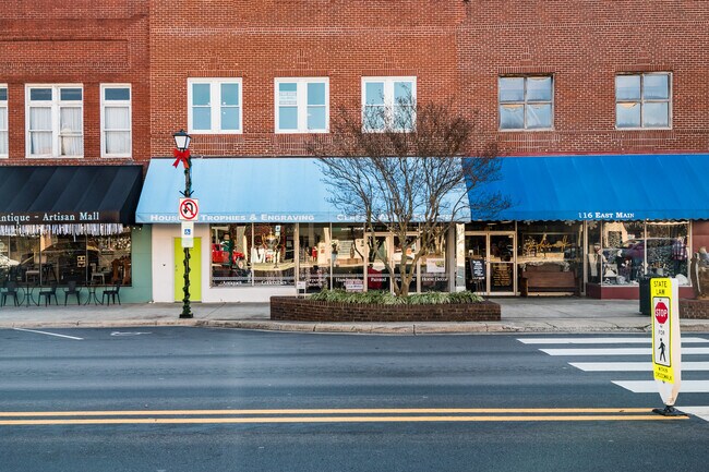
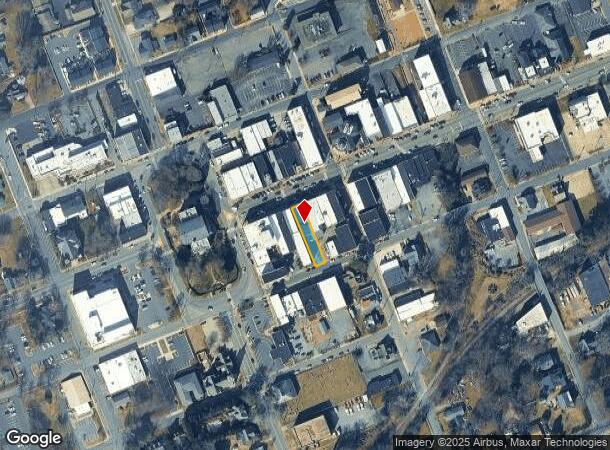
Property Record
118 E Main St, Lincolnton, NC 28092

NEARBY LISTINGS FOR SALE OR LEASE
-
-
View all Lincolnton listings for sale on LoopNet.com
Property Detail
118 E Main St
Charlotte-Concord-Gastonia, NC-SC
E MAIN ST
00905
Lincoln
Storebuilding
North Carolina
2025
0.16 AC
2025
Lincoln County
070100
Charlotte
7,027 SF
DEMOGRAPHICS near 118 E Main St
1 mile
3 mile
5 mile
2024 Total Population
5,233
18,638
33,375
2029 Population
6,110
21,677
38,720
Pop Growth 2024-2029
+ 16.76%
+ 16.31%
+ 16.01%
Average Age
42
42
42
2024 Total Households
2,339
7,706
13,552
HH Growth 2024-2029
+ 17.23%
+ 16.70%
+ 16.36%
Median Household Inc
$53,197
$54,536
$59,227
Avg Household Size
2.20
2.30
2.40
2024 Avg HH Vehicles
2.00
2.00
2.00
Median Home Value
$176,334
$176,712
$173,111
Median Year Built
1959
1979
1983
Nearby Places
Map Layers
Map Styles
 Street
 Aerial
Transit
 Traffic
 Biking
Places
Listings with unknown addresses are not visible on the map
- Restaurants
- Banks
- Shops
- Fitness
- Groceries
PUBLIC TRANSPORTATION
AIRPORT
Charlotte/Douglas International
Drive
Walk
Distance
Charlotte/Douglas International
52 min
33.1 mi
Concord-Padgett Regional
Drive
Walk
Distance
Concord-Padgett Regional
60 min
41.1 mi
SALE & LEASE HISTORY
LISTING DATE
SALE/LEASE

Jan 11, 2021
For Sale
Nearby Properties
Address
Land Use
TOTAL SIZE
Lot Size
Zoning
Address
Land Use
TOTAL SIZE
Lot Size
Zoning
88,878 SF
7.21 AC
O-I
Address
Land Use
TOTAL SIZE
Lot Size
Zoning
99,626 SF
21.55 AC
R-SF
Address
Land Use
TOTAL SIZE
Lot Size
Zoning
322,560 SF
132.94 AC
I-G
Address
Land Use
TOTAL SIZE
Lot Size
Zoning
6,144 SF
13.26 AC
P-B & RMF
Address
Land Use
TOTAL SIZE
Lot Size
Zoning
118,694 SF
25.90 AC
R-10
Address
Land Use
TOTAL SIZE
Lot Size
Zoning
45,354 SF
50.76 AC
R-10
Address
Land Use
TOTAL SIZE
Lot Size
Zoning
53,152 SF
3.97 AC
G-B CD
Address
Land Use
TOTAL SIZE
Lot Size
Zoning
189,220 SF
23.64 AC
P-B CU
Address
Land Use
TOTAL SIZE
Lot Size
Zoning
80,509 SF
16.23 AC
P-B CU
Address
Land Use
TOTAL SIZE
Lot Size
Zoning
1,488 SF
10.65 AC
O-I CU
Address
Land Use
TOTAL SIZE
Lot Size
Zoning
36,448 SF
7.73 AC
RMF
Address
Land Use
TOTAL SIZE
Lot Size
Zoning
10,120 SF
23.38 AC
G-B & P-B
Address
Land Use
TOTAL SIZE
Lot Size
Zoning
42,405 SF
34.47 AC
GMC
Address
Land Use
TOTAL SIZE
Lot Size
Zoning
2,047 SF
46.35 AC
RMF
Address
Land Use
TOTAL SIZE
Lot Size
Zoning
39,860 SF
3.71 AC
O-I
Address
Land Use
TOTAL SIZE
Lot Size
Zoning
4,475 SF
14.98 AC
R-15
Address
Land Use
TOTAL SIZE
Lot Size
Zoning
8,770 SF
11.21 AC
P-B
Address
Land Use
TOTAL SIZE
Lot Size
Zoning
52,000 SF
10.06 AC
O-I
Address
Land Use
TOTAL SIZE
Lot Size
Zoning
120,810 SF
16.90 AC
G-B CU
Address
Land Use
TOTAL SIZE
Lot Size
Zoning
66,527 SF
2.10 AC
R-15
Address
Land Use
TOTAL SIZE
Lot Size
Zoning
40,203 SF
3.37 AC
P-B
Address
Land Use
TOTAL SIZE
Lot Size
Zoning
11,248 SF
5.23 AC
G-B & R-8
Address
Land Use
TOTAL SIZE
Lot Size
Zoning
41,016 SF
4 AC
G-B
Address
Land Use
TOTAL SIZE
Lot Size
Zoning
42,882 SF
10.52 AC
P-B
Address
Land Use
TOTAL SIZE
Lot Size
Zoning
63,404 SF
26 AC
GMC
Address
Land Use
TOTAL SIZE
Lot Size
Zoning
36,100 SF
3.38 AC
R-8
Address
Land Use
TOTAL SIZE
Lot Size
Zoning
522,930 SF
25.71 AC
GMC & O-I
Address
Land Use
TOTAL SIZE
Lot Size
Zoning
96,888 SF
14.66 AC
G-B & P-B
Address
Land Use
TOTAL SIZE
Lot Size
Zoning
39,474 SF
1.39 AC
C-B
Address
Land Use
TOTAL SIZE
Lot Size
Zoning
132,221 SF
7.16 AC
P-B
The World's #1 Commercial Real Estate Marketplace
Connect with us
© 2026 CoStar Group
The information above has been obtained from sources believed reliable. While we do not doubt its accuracy we have not verified it and make no guarantee, warranty or representation about it. It is your responsibility to independently confirm its accuracy and completeness. Any projections, opinions, assumptions, or estimates used are for example only and do not represent the current or future performance of the property. The value of this transaction to you depends on tax and other factors which should be evaluated by your tax, financial, and legal advisors. You and your advisors should conduct a careful, independent investigation of the property to determine to your satisfaction the suitability of the property for your needs.