Property Record
118 Florida Dr, Auburndale, FL 33823

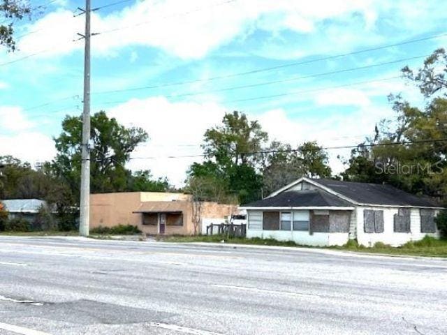
This Property Is For Sale
NEARBY LISTINGS FOR SALE OR LEASE
Property Detail
118 Florida Dr
Lakeland-Winter Haven, FL
Lena Vista Subdivision
25-28-04-319001-015110
LENA VISTA SUB PB 13 PG 42 & 42A S3/4/9 28 R25 BLK 15 LOTS 14 THRU 16 LESS R/W FOR BERKLEY RD AS DESC IN OR 7681 PGS 1792
Sfr
Polk
X
Florida
12105C0330G
14-16
2024
0.50 AC
2025
Polk County
013102
Tampa/St Petersburg
960 SF
DEMOGRAPHICS near 118 Florida Dr
1 Mile
3 Mile
5 Mile
2024 Total Population
5,263
30,604
68,328
2029 Population
6,184
36,219
81,490
Pop Growth 2024-2029
+ 17.50%
+ 18.35%
+ 19.26%
Average Age
40
41
41
2024 Total Households
2,078
11,577
26,289
HH Growth 2024-2029
+ 17.52%
+ 18.32%
+ 19.32%
Median Household Inc
$41,189
$58,701
$57,052
Avg Household Size
2.50
2.60
2.50
2024 Avg HH Vehicles
2.00
2.00
2.00
Median Home Value
$170,062
$186,199
$186,383
Median Year Built
1979
1987
1986
Nearby Places
Map Layers
Map Styles
 Street
 Aerial
- Restaurants
- Banks
- Shops
- Fitness
- Groceries
PUBLIC TRANSPORTATION
COMMUTER RAIL
Winter Haven (Silver Meteor - Amtrak, Silver Star - Amtrak)
DRIVE
WALK
Distance
Winter Haven (Silver Meteor - Amtrak, Silver Star - Amtrak)
15 min
8.5 mi
Lakeland (Silver Star - Amtrak)
DRIVE
WALK
Distance
Lakeland (Silver Star - Amtrak)
16 min
9.6 mi
Freight Ports
Port of Tampa Bay
DRIVE
WALK
Distance
Port of Tampa Bay
61 min
43.7 mi
Nearby Properties
Address
Land Use
TOTAL SIZE
Lot Size
Zoning
Address
Land Use
TOTAL SIZE
Lot Size
Zoning
831,600 SF
51.22 AC
Address
Land Use
TOTAL SIZE
Lot Size
Zoning
811,392 SF
47.70 AC
Address
Land Use
TOTAL SIZE
Lot Size
Zoning
942,646 SF
91.30 AC
R3
Address
Land Use
TOTAL SIZE
Lot Size
Zoning
275,220 SF
94.53 AC
Address
Land Use
TOTAL SIZE
Lot Size
Zoning
238,721 SF
11.66 AC
GI
Address
Land Use
TOTAL SIZE
Lot Size
Zoning
136,724 SF
4.62 AC
GI
Address
Land Use
TOTAL SIZE
Lot Size
Zoning
108,360 SF
4.23 AC
GI
Address
Land Use
TOTAL SIZE
Lot Size
Zoning
188,553 SF
29.12 AC
Address
Land Use
TOTAL SIZE
Lot Size
Zoning
178,899 SF
10.09 AC
GI
Address
Land Use
TOTAL SIZE
Lot Size
Zoning
241,319 SF
5.67 AC
Address
Land Use
TOTAL SIZE
Lot Size
Zoning
291,428 SF
59.34 AC
Address
Land Use
TOTAL SIZE
Lot Size
Zoning
129,567 SF
11.72 AC
C3
Address
Land Use
TOTAL SIZE
Lot Size
Zoning
135,247 SF
22.49 AC
C4
Address
Land Use
TOTAL SIZE
Lot Size
Zoning
91,962 SF
19.46 AC
R4
Address
Land Use
TOTAL SIZE
Lot Size
Zoning
191,975 SF
14.28 AC
HI
Address
Land Use
TOTAL SIZE
Lot Size
Zoning
174,108 SF
4.82 AC
Address
Land Use
TOTAL SIZE
Lot Size
Zoning
126,384 SF
4.67 AC
CH
Address
Land Use
TOTAL SIZE
Lot Size
Zoning
160,755 SF
9.94 AC
Address
Land Use
TOTAL SIZE
Lot Size
Zoning
320,765 SF
14.93 AC
GI
Address
Land Use
TOTAL SIZE
Lot Size
Zoning
42,400 SF
121.06 AC
RC
Address
Land Use
TOTAL SIZE
Lot Size
Zoning
106,376 SF
18.36 AC
Address
Land Use
TOTAL SIZE
Lot Size
Zoning
243,600 SF
35.47 AC
C4
Address
Land Use
TOTAL SIZE
Lot Size
Zoning
42,668 SF
9.44 AC
R2
Address
Land Use
TOTAL SIZE
Lot Size
Zoning
169,925 SF
11.88 AC
C3
Address
Land Use
TOTAL SIZE
Lot Size
Zoning
309,124 SF
31.33 AC
XX
Address
Land Use
TOTAL SIZE
Lot Size
Zoning
80,280 SF
25.05 AC
Address
Land Use
TOTAL SIZE
Lot Size
Zoning
122,260 SF
4.77 AC
Address
Land Use
TOTAL SIZE
Lot Size
Zoning
90,077 SF
12.41 AC
Address
Land Use
TOTAL SIZE
Lot Size
Zoning
69,835 SF
7.06 AC
CH
Address
Land Use
TOTAL SIZE
Lot Size
Zoning
84,312 SF
13.64 AC
The World's #1 Commercial Real Estate Marketplace
Connect with us
© 2025 CoStar Group
The information above has been obtained from sources believed reliable. While we do not doubt its accuracy we have not verified it and make no guarantee, warranty or representation about it. It is your responsibility to independently confirm its accuracy and completeness. Any projections, opinions, assumptions, or estimates used are for example only and do not represent the current or future performance of the property. The value of this transaction to you depends on tax and other factors which should be evaluated by your tax, financial, and legal advisors. You and your advisors should conduct a careful, independent investigation of the property to determine to your satisfaction the suitability of the property for your needs.