Property Record
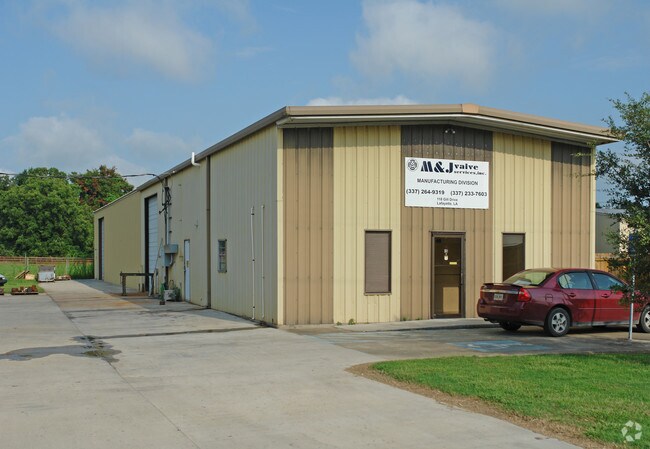
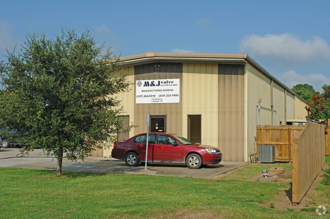
118 Gill Dr, , LA

Property Detail
118 Gill Dr
6117466
P TR 2 SEC 49 T9S R4E (0.442 AC)(99.45X194X99.5X193.99)
Warehouse
LAFAYETTE
B and X Area of moderate flood hazard, usually the area between the limits of the 100-year and 500-year floods.
Louisiana
2025
0.44 AC
2025
Greater Lafayette
0010011059
Lafayette
4,350 SF
Lafayette, LA
NEARBY LISTINGS FOR SALE OR LEASE
-
-
No Photo
-
View all listings for sale on LoopNet.com
DEMOGRAPHICS near 118 Gill Dr
1 mile
3 mile
5 mile
2025 Total Population
3,476
41,047
94,032
2030 Population
3,654
43,193
98,552
Pop Growth 2025-2030
+ 5.12%
+ 5.23%
+ 4.81%
Average Age
38
39
39
2025 Total Households
1,514
16,152
38,483
HH Growth 2025-2030
+ 5.15%
+ 5.31%
+ 4.87%
Median Household Inc
$57,020
$47,132
$48,701
Avg Household Size
2.20
2.40
2.30
2025 Avg HH Vehicles
2.00
2.00
2.00
Median Home Value
$188,621
$164,172
$197,265
Median Year Built
1984
1979
1978
Nearby Places
Map Layers
Map Styles
 Street
 Aerial
Transit
 Traffic
 Biking
Places
Listings with unknown addresses are not visible on the map
- Restaurants
- Banks
- Shops
- Fitness
- Groceries
PUBLIC TRANSPORTATION
COMMUTER RAIL
Lafayette Amtrak Station (Sunset Limited - Amtrak)
Drive
Walk
Distance
Lafayette Amtrak Station (Sunset Limited - Amtrak)
7 min
3.8 mi
AIRPORT
Lafayette Regional/Paul Fournet Field
Drive
Walk
Distance
Lafayette Regional/Paul Fournet Field
11 min
5.9 mi
Freight Ports
Port of Iberia
Drive
Walk
Distance
Port of Iberia
37 min
27.2 mi
Nearby Properties
Address
Land Use
TOTAL SIZE
Lot Size
Zoning
Address
Land Use
TOTAL SIZE
Lot Size
Zoning
1,076,123 SF
113.74 AC
Address
Land Use
TOTAL SIZE
Lot Size
Zoning
181,875 SF
50.80 AC
Address
Land Use
TOTAL SIZE
Lot Size
Zoning
141,295 SF
28.09 AC
Address
Land Use
TOTAL SIZE
Lot Size
Zoning
10.80 AC
Address
Land Use
TOTAL SIZE
Lot Size
Zoning
119,726 SF
25.22 AC
Address
Land Use
TOTAL SIZE
Lot Size
Zoning
236,530 SF
39.98 AC
Address
Land Use
TOTAL SIZE
Lot Size
Zoning
182,700 SF
25.62 AC
Address
Land Use
TOTAL SIZE
Lot Size
Zoning
423,600 SF
24.16 AC
Address
Land Use
TOTAL SIZE
Lot Size
Zoning
84,009 SF
6.90 AC
Address
Land Use
TOTAL SIZE
Lot Size
Zoning
47,249 SF
22.17 AC
Address
Land Use
TOTAL SIZE
Lot Size
Zoning
203,442 SF
39.38 AC
Address
Land Use
TOTAL SIZE
Lot Size
Zoning
15,138 SF
18.57 AC
Address
Land Use
TOTAL SIZE
Lot Size
Zoning
164,478 SF
40 AC
Address
Land Use
TOTAL SIZE
Lot Size
Zoning
69,500 SF
29.03 AC
Address
Land Use
TOTAL SIZE
Lot Size
Zoning
22,335 SF
30.61 AC
Address
Land Use
TOTAL SIZE
Lot Size
Zoning
26,943 SF
4.30 AC
Address
Land Use
TOTAL SIZE
Lot Size
Zoning
142,882 SF
9.75 AC
Address
Land Use
TOTAL SIZE
Lot Size
Zoning
60,332 SF
13.67 AC
Address
Land Use
TOTAL SIZE
Lot Size
Zoning
116,010 SF
25.46 AC
Address
Land Use
TOTAL SIZE
Lot Size
Zoning
Address
Land Use
TOTAL SIZE
Lot Size
Zoning
32,098 SF
3.67 AC
Address
Land Use
TOTAL SIZE
Lot Size
Zoning
Address
Land Use
TOTAL SIZE
Lot Size
Zoning
15,190 SF
49.84 AC
Address
Land Use
TOTAL SIZE
Lot Size
Zoning
26,637 SF
11 AC
Address
Land Use
TOTAL SIZE
Lot Size
Zoning
135,723 SF
16.14 AC
Address
Land Use
TOTAL SIZE
Lot Size
Zoning
69,805 SF
6.26 AC
Address
Land Use
TOTAL SIZE
Lot Size
Zoning
81,871 SF
7.23 AC
Address
Land Use
TOTAL SIZE
Lot Size
Zoning
64,002 SF
7.78 AC
Address
Land Use
TOTAL SIZE
Lot Size
Zoning
98,591 SF
25.08 AC
Address
Land Use
TOTAL SIZE
Lot Size
Zoning
126,772 SF
10.34 AC
The World's #1 Commercial Real Estate Marketplace
Connect with us
© 2026 CoStar Group
The information above has been obtained from sources believed reliable. While we do not doubt its accuracy we have not verified it and make no guarantee, warranty or representation about it. It is your responsibility to independently confirm its accuracy and completeness. Any projections, opinions, assumptions, or estimates used are for example only and do not represent the current or future performance of the property. The value of this transaction to you depends on tax and other factors which should be evaluated by your tax, financial, and legal advisors. You and your advisors should conduct a careful, independent investigation of the property to determine to your satisfaction the suitability of the property for your needs.