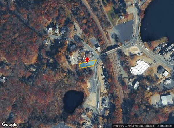
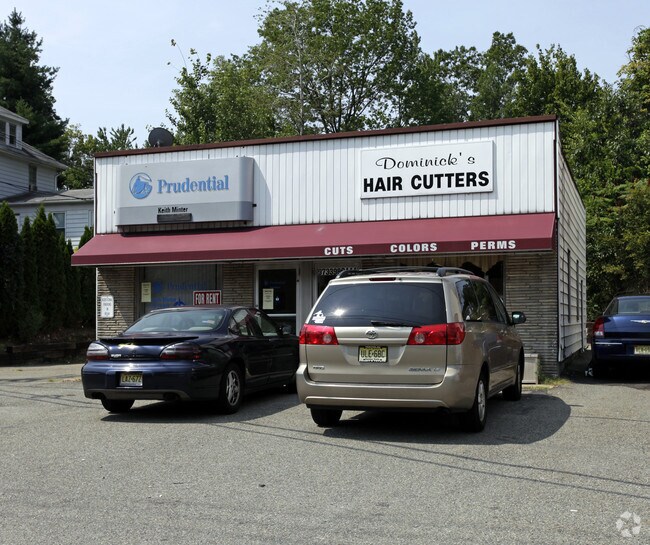
Property Record
118 Landing Rd, Landing, NJ 07850

NEARBY LISTINGS FOR SALE OR LEASE
Property Detail
118 Landing Rd
Newark, NJ-PA
Morris
36-10020-0000-00008
New Jersey
Commercialnec
8
2024
0.19 AC
2025
Western Morris
045402
Northern New Jersey
1,020 SF
DEMOGRAPHICS near 118 Landing Rd
1 Mile
3 Mile
5 Mile
2024 Total Population
4,102
38,660
90,814
2029 Population
4,136
38,941
91,318
Pop Growth 2024-2029
+ 0.83%
+ 0.73%
+ 0.55%
Average Age
41
43
42
2024 Total Households
1,580
15,408
35,041
HH Growth 2024-2029
+ 0.89%
+ 0.78%
+ 0.56%
Median Household Inc
$91,748
$95,998
$103,534
Avg Household Size
2.50
2.40
2.50
2024 Avg HH Vehicles
2.00
2.00
2.00
Median Home Value
$332,700
$322,589
$358,408
Median Year Built
1967
1969
1970
Nearby Places
Map Layers
Map Styles
 Street
 Aerial
- Restaurants
- Banks
- Shops
- Fitness
- Groceries
PUBLIC TRANSPORTATION
COMMUTER RAIL
Lake Hopatcong (Montclair-Boonton Line - NJ Transit Commuter Rail (NJ Transit), Morris & Essex Morristown Line - NJ Transit Commuter Rail (NJ Transit))
DRIVE
WALK
Distance
Lake Hopatcong (Montclair-Boonton Line - NJ Transit Commuter Rail (NJ Transit), Morris & Essex Morristown Line - NJ Transit Commuter Rail (NJ Transit))
1 min
4 min
0.2 mi
Mount Arlington (Montclair-Boonton Line - NJ Transit Commuter Rail (NJ Transit), Morris & Essex Morristown Line - NJ Transit Commuter Rail (NJ Transit))
DRIVE
WALK
Distance
Mount Arlington (Montclair-Boonton Line - NJ Transit Commuter Rail (NJ Transit), Morris & Essex Morristown Line - NJ Transit Commuter Rail (NJ Transit))
4 min
2.9 mi
AIRPORT
Newark Liberty International
DRIVE
WALK
Distance
Newark Liberty International
46 min
37.3 mi
Freight Ports
Maher Terminal
DRIVE
WALK
Distance
Maher Terminal
49 min
37.8 mi
Nearby Properties
Address
Land Use
TOTAL SIZE
Lot Size
Zoning
Address
Land Use
TOTAL SIZE
Lot Size
Zoning
Address
Land Use
TOTAL SIZE
Lot Size
Zoning
25.63 AC
B-3
Address
Land Use
TOTAL SIZE
Lot Size
Zoning
56.90 AC
Address
Land Use
TOTAL SIZE
Lot Size
Zoning
23.74 AC
B-3
Address
Land Use
TOTAL SIZE
Lot Size
Zoning
280,960 SF
46.25 AC
R-4
Address
Land Use
TOTAL SIZE
Lot Size
Zoning
44.67 AC
R2
Address
Land Use
TOTAL SIZE
Lot Size
Zoning
72.81 AC
LIOR
Address
Land Use
TOTAL SIZE
Lot Size
Zoning
8.19 AC
B-3
Address
Land Use
TOTAL SIZE
Lot Size
Zoning
440.89 AC
POLI
Address
Land Use
TOTAL SIZE
Lot Size
Zoning
6.74 AC
TC
Address
Land Use
TOTAL SIZE
Lot Size
Zoning
48.48 AC
MLR
Address
Land Use
TOTAL SIZE
Lot Size
Zoning
136,928 SF
15.72 AC
C-LI
Address
Land Use
TOTAL SIZE
Lot Size
Zoning
126,875 SF
7.02 AC
Address
Land Use
TOTAL SIZE
Lot Size
Zoning
55.26 AC
PUD
Address
Land Use
TOTAL SIZE
Lot Size
Zoning
249,480 SF
5.66 AC
FTZ1
Address
Land Use
TOTAL SIZE
Lot Size
Zoning
79,962 SF
27.80 AC
GU
Address
Land Use
TOTAL SIZE
Lot Size
Zoning
13.63 AC
FTZ4
Address
Land Use
TOTAL SIZE
Lot Size
Zoning
102,512 SF
17 AC
C-LI
Address
Land Use
TOTAL SIZE
Lot Size
Zoning
142,168 SF
14.84 AC
C-LI
Address
Land Use
TOTAL SIZE
Lot Size
Zoning
220,912 SF
56.21 AC
FTZ1
Address
Land Use
TOTAL SIZE
Lot Size
Zoning
132,312 SF
12.13 AC
C-LI
Address
Land Use
TOTAL SIZE
Lot Size
Zoning
20.85 AC
I-3
Address
Land Use
TOTAL SIZE
Lot Size
Zoning
8.43 AC
B-3
Address
Land Use
TOTAL SIZE
Lot Size
Zoning
68,844 SF
5 AC
PUD
Address
Land Use
TOTAL SIZE
Lot Size
Zoning
134,760 SF
14 AC
C-LI
Address
Land Use
TOTAL SIZE
Lot Size
Zoning
89.81 AC
R-2
Address
Land Use
TOTAL SIZE
Lot Size
Zoning
133,934 SF
21.46 AC
PUD
Address
Land Use
TOTAL SIZE
Lot Size
Zoning
27.96 AC
R2
Address
Land Use
TOTAL SIZE
Lot Size
Zoning
65,128 SF
1.69 AC
B-2
Address
Land Use
TOTAL SIZE
Lot Size
Zoning
3.90 AC
RG-5
The World's #1 Commercial Real Estate Marketplace
Connect with us
© 2025 CoStar Group
The information above has been obtained from sources believed reliable. While we do not doubt its accuracy we have not verified it and make no guarantee, warranty or representation about it. It is your responsibility to independently confirm its accuracy and completeness. Any projections, opinions, assumptions, or estimates used are for example only and do not represent the current or future performance of the property. The value of this transaction to you depends on tax and other factors which should be evaluated by your tax, financial, and legal advisors. You and your advisors should conduct a careful, independent investigation of the property to determine to your satisfaction the suitability of the property for your needs.