Property Record
890 East St, Tewksbury, MA 01876


NEARBY LISTINGS FOR SALE OR LEASE
Property Detail
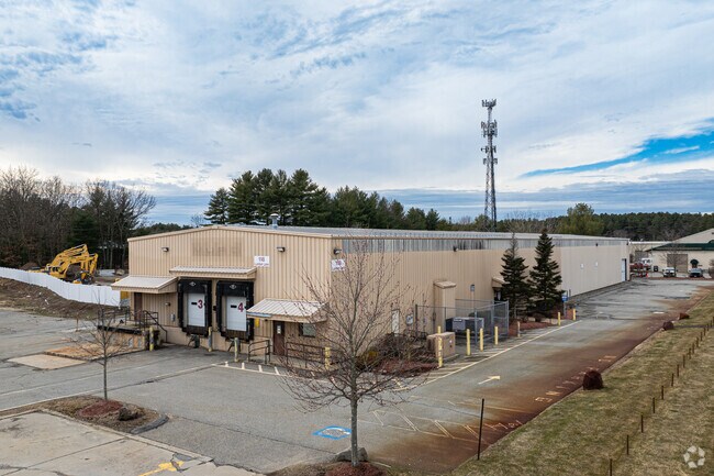
890 East St
TEWK-000102-000000-000015
Middlesex
Warehouse
Massachusetts
X
15
25017C0277G
4.59 AC
2025
Lowell/Chelmsford
2025
Boston
315402
Boston-Cambridge-Newton, MA-NH
63,896 SF
DEMOGRAPHICS near 890 East St
1 Mile
3 Mile
5 Mile
2024 Total Population
3,133
33,209
117,993
2029 Population
3,097
32,966
117,120
Pop Growth 2024-2029
(1.15%)
(0.73%)
(0.74%)
Average Age
45
43
42
2024 Total Households
1,194
12,280
42,921
HH Growth 2024-2029
(1.26%)
(0.86%)
(0.84%)
Median Household Inc
$117,950
$122,660
$123,030
Avg Household Size
2.60
2.60
2.70
2024 Avg HH Vehicles
2.00
2.00
2.00
Median Home Value
$627,400
$608,866
$594,202
Median Year Built
1986
1981
1973
Nearby Places
Map Layers
Map Styles
 Street
 Aerial
- Restaurants
- Banks
- Shops
- Fitness
- Groceries
PUBLIC TRANSPORTATION
COMMUTER RAIL
Ballardvale (Haverhill Line - Massachusetts Bay Transportation Authority Commuter Rail (Purple Line))
DRIVE
WALK
Distance
Ballardvale (Haverhill Line - Massachusetts Bay Transportation Authority Commuter Rail (Purple Line))
6 min
2.5 mi
Andover (Haverhill Line - Massachusetts Bay Transportation Authority Commuter Rail (Purple Line))
DRIVE
WALK
Distance
Andover (Haverhill Line - Massachusetts Bay Transportation Authority Commuter Rail (Purple Line))
9 min
4.4 mi
AIRPORT
General Edward Lawrence Logan International
DRIVE
WALK
Distance
General Edward Lawrence Logan International
34 min
24.0 mi
Manchester Boston Regional
DRIVE
WALK
Distance
Manchester Boston Regional
47 min
31.9 mi
Freight Ports
Port of Boston
DRIVE
WALK
Distance
Port of Boston
34 min
23.8 mi
SALE & LEASE HISTORY
LISTING DATE
SALE/LEASE

Mar 03, 2023
For Lease
Dec 01, 2016
For Lease
Nearby Properties
Address
Land Use
TOTAL SIZE
Lot Size
Zoning
Address
Land Use
TOTAL SIZE
Lot Size
Zoning
52.80 AC
OR
Address
Land Use
TOTAL SIZE
Lot Size
Zoning
0.24 AC
SRC
Address
Land Use
TOTAL SIZE
Lot Size
Zoning
44.42 AC
LS
Address
Land Use
TOTAL SIZE
Lot Size
Zoning
25 AC
MN
Address
Land Use
TOTAL SIZE
Lot Size
Zoning
1,616 SF
206.08 AC
R40
Address
Land Use
TOTAL SIZE
Lot Size
Zoning
341,215 SF
16.94 AC
IND
Address
Land Use
TOTAL SIZE
Lot Size
Zoning
591,906 SF
153.43 AC
IA
Address
Land Use
TOTAL SIZE
Lot Size
Zoning
19.04 AC
MFD
Address
Land Use
TOTAL SIZE
Lot Size
Zoning
67.55 AC
OR
Address
Land Use
TOTAL SIZE
Lot Size
Zoning
509.76 AC
IA
Address
Land Use
TOTAL SIZE
Lot Size
Zoning
308.52 AC
IA
Address
Land Use
TOTAL SIZE
Lot Size
Zoning
218,780 SF
55.49 AC
MN
Address
Land Use
TOTAL SIZE
Lot Size
Zoning
343,105 SF
60.18 AC
IND
Address
Land Use
TOTAL SIZE
Lot Size
Zoning
40.44 AC
MFD
Address
Land Use
TOTAL SIZE
Lot Size
Zoning
221,927 SF
27.88 AC
IND
Address
Land Use
TOTAL SIZE
Lot Size
Zoning
193.30 AC
IA
Address
Land Use
TOTAL SIZE
Lot Size
Zoning
447,869 SF
27.06 AC
ID
Address
Land Use
TOTAL SIZE
Lot Size
Zoning
484,857 SF
42.05 AC
HI
Address
Land Use
TOTAL SIZE
Lot Size
Zoning
150,000 SF
30.73 AC
LS
Address
Land Use
TOTAL SIZE
Lot Size
Zoning
9.80 AC
R40
Address
Land Use
TOTAL SIZE
Lot Size
Zoning
180,640 SF
16.24 AC
ID2
Address
Land Use
TOTAL SIZE
Lot Size
Zoning
113,912 SF
5.67 AC
MFD
Address
Land Use
TOTAL SIZE
Lot Size
Zoning
107,001 SF
21.82 AC
MN
Address
Land Use
TOTAL SIZE
Lot Size
Zoning
26.32 AC
IA
Address
Land Use
TOTAL SIZE
Lot Size
Zoning
30,240 SF
5.78 AC
LS
Address
Land Use
TOTAL SIZE
Lot Size
Zoning
135,500 SF
17.96 AC
OR
Address
Land Use
TOTAL SIZE
Lot Size
Zoning
73.74 AC
IH
Address
Land Use
TOTAL SIZE
Lot Size
Zoning
133,877 SF
16.30 AC
IND
Address
Land Use
TOTAL SIZE
Lot Size
Zoning
112,330 SF
17.06 AC
IA
Address
Land Use
TOTAL SIZE
Lot Size
Zoning
167,654 SF
14.84 AC
GI
The World's #1 Commercial Real Estate Marketplace
Connect with us
© 2026 CoStar Group
The information above has been obtained from sources believed reliable. While we do not doubt its accuracy we have not verified it and make no guarantee, warranty or representation about it. It is your responsibility to independently confirm its accuracy and completeness. Any projections, opinions, assumptions, or estimates used are for example only and do not represent the current or future performance of the property. The value of this transaction to you depends on tax and other factors which should be evaluated by your tax, financial, and legal advisors. You and your advisors should conduct a careful, independent investigation of the property to determine to your satisfaction the suitability of the property for your needs.