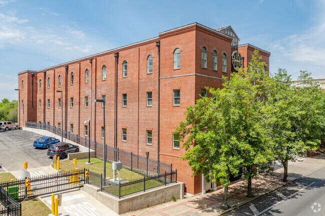
Property Record
118 N Monroe St, Tallahassee, FL 32301


Current Lease Availabilities
NEARBY LISTINGS FOR SALE OR LEASE
Property Detail
118 N Monroe St
Tallahassee, FL
Old Courthouse Square
21-36-45-008-000.0
OLD C H SQ N A LOT 8 DB 227/571 OR 1315/1275 1530/2098 OR 2241/530 2318/1673 FLORIDA THEATRE
Officebuilding
Leon
X
Florida
12073C0284F
8
2025
0.22 AC
2025
Downtown Tallahassee
000200
Tallahassee
27,770 SF
DEMOGRAPHICS near 118 N Monroe St
1 Mile
3 Mile
5 Mile
2024 Total Population
13,533
97,486
178,308
2029 Population
14,018
101,470
187,395
Pop Growth 2024-2029
+ 3.58%
+ 4.09%
+ 5.10%
Average Age
31
33
35
2024 Total Households
6,302
43,350
77,363
HH Growth 2024-2029
+ 4.35%
+ 4.37%
+ 5.30%
Median Household Inc
$36,624
$40,259
$45,990
Avg Household Size
1.70
2.00
2.10
2024 Avg HH Vehicles
1.00
2.00
2.00
Median Home Value
$311,575
$205,204
$201,621
Median Year Built
1976
1979
1985
Nearby Places
Map Layers
Map Styles
 Street
 Aerial
- Restaurants
- Banks
- Shops
- Fitness
- Groceries
PUBLIC TRANSPORTATION
AIRPORT
Tallahassee International
DRIVE
WALK
Distance
Tallahassee International
16 min
7.0 mi
Nearby Properties
Address
Land Use
TOTAL SIZE
Lot Size
Zoning
Address
Land Use
TOTAL SIZE
Lot Size
Zoning
1,635,322 SF
29.76 AC
UT
Address
Land Use
TOTAL SIZE
Lot Size
Zoning
6,686,582 SF
86.50 AC
UT
Address
Land Use
TOTAL SIZE
Lot Size
Zoning
4,577,528 SF
108.47 AC
UT
Address
Land Use
TOTAL SIZE
Lot Size
Zoning
3,647,358 SF
49.17 AC
UT
Address
Land Use
TOTAL SIZE
Lot Size
Zoning
3,882,850 SF
22.64 AC
CM
Address
Land Use
TOTAL SIZE
Lot Size
Zoning
2,330,342 SF
69.26 AC
UT
Address
Land Use
TOTAL SIZE
Lot Size
Zoning
807,298 SF
145.81 AC
UT
Address
Land Use
TOTAL SIZE
Lot Size
Zoning
2,312,757 SF
10.87 AC
CCPD
Address
Land Use
TOTAL SIZE
Lot Size
Zoning
479,864 SF
19.01 AC
DI
Address
Land Use
TOTAL SIZE
Lot Size
Zoning
1,545,007 SF
44.85 AC
UT
Address
Land Use
TOTAL SIZE
Lot Size
Zoning
859,455 SF
3.79 AC
CU45
Address
Land Use
TOTAL SIZE
Lot Size
Zoning
367,978 SF
2.52 AC
RO
Address
Land Use
TOTAL SIZE
Lot Size
Zoning
704,857 SF
4.95 AC
UT
Address
Land Use
TOTAL SIZE
Lot Size
Zoning
806,710 SF
2.96 AC
CCPD
Address
Land Use
TOTAL SIZE
Lot Size
Zoning
664,514 SF
2.49 AC
UT
Address
Land Use
TOTAL SIZE
Lot Size
Zoning
369,383 SF
4.51 AC
UT
Address
Land Use
TOTAL SIZE
Lot Size
Zoning
899,528 SF
3.34 AC
CCPD
Address
Land Use
TOTAL SIZE
Lot Size
Zoning
758,762 SF
20.82 AC
UT
Address
Land Use
TOTAL SIZE
Lot Size
Zoning
307,884 SF
2.97 AC
CCPD
Address
Land Use
TOTAL SIZE
Lot Size
Zoning
616,484 SF
30.15 AC
UT
Address
Land Use
TOTAL SIZE
Lot Size
Zoning
428,190 SF
2.24 AC
CCPD
Address
Land Use
TOTAL SIZE
Lot Size
Zoning
452,530 SF
10.30 AC
UV
Address
Land Use
TOTAL SIZE
Lot Size
Zoning
445,676 SF
23.50 AC
PUD
Address
Land Use
TOTAL SIZE
Lot Size
Zoning
756,294 SF
20.19 AC
OR3
Address
Land Use
TOTAL SIZE
Lot Size
Zoning
249,612 SF
1.67 AC
CCPD
Address
Land Use
TOTAL SIZE
Lot Size
Zoning
456,149 SF
22.50 AC
OR3
Address
Land Use
TOTAL SIZE
Lot Size
Zoning
652,729 SF
1.71 AC
UT
Address
Land Use
TOTAL SIZE
Lot Size
Zoning
721,205 SF
6.19 AC
UT
Address
Land Use
TOTAL SIZE
Lot Size
Zoning
414,216 SF
2.23 AC
CU45
Address
Land Use
TOTAL SIZE
Lot Size
Zoning
498,616 SF
2.03 AC
CCPD
The World's #1 Commercial Real Estate Marketplace
Connect with us
© 2025 CoStar Group
The information above has been obtained from sources believed reliable. While we do not doubt its accuracy we have not verified it and make no guarantee, warranty or representation about it. It is your responsibility to independently confirm its accuracy and completeness. Any projections, opinions, assumptions, or estimates used are for example only and do not represent the current or future performance of the property. The value of this transaction to you depends on tax and other factors which should be evaluated by your tax, financial, and legal advisors. You and your advisors should conduct a careful, independent investigation of the property to determine to your satisfaction the suitability of the property for your needs.