Property Record
118 Nopalitos Way, Santa Barbara, CA 93103
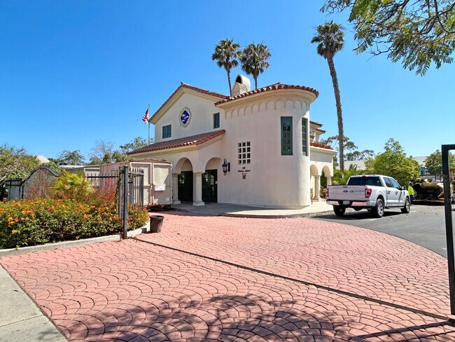


Property Detail
118 Nopalitos Way
Santa Maria-Santa Barbara, CA
MAP 4 PG 3 BLK 343 PART OF LOT 6,11 & OTHER LOTS
017-202-013
Santa Barbara
Officebuilding
California
M1SD3
6
B and X Area of moderate flood hazard, usually the area between the limits of the 100-year and 500-year floods.
0.54 AC
2024
N Santa Barbara/Goleta
2025
Santa Barbara/Sta Maria/Goleta
000805
NEARBY LISTINGS FOR SALE OR LEASE
DEMOGRAPHICS near 118 Nopalitos Way
1 mile
3 mile
5 mile
2025 Total Population
14,513
73,143
103,929
2030 Population
14,364
72,838
103,837
Pop Growth 2025-2030
(1.03%)
(0.42%)
(0.09%)
Average Age
39
41
42
2025 Total Households
4,969
29,024
41,385
HH Growth 2025-2030
(0.83%)
(0.44%)
(0.13%)
Median Household Inc
$73,918
$97,361
$106,884
Avg Household Size
2.60
2.40
2.30
2025 Avg HH Vehicles
2.00
2.00
2.00
Median Home Value
$1,077,944
$1,119,200
$1,122,244
Median Year Built
1964
1962
1964
Nearby Places
Map Layers
Map Styles
 Street
 Aerial
Layers
 Traffic
 Biking
Places
Listings with unknown addresses are not visible on the map
- Restaurants
- Banks
- Shops
- Fitness
- Groceries
PUBLIC TRANSPORTATION
COMMUTER RAIL
Drive
Walk
Distance
4 min
1.1 mi
Drive
Walk
Distance
15 min
9.9 mi
AIRPORT
Santa Barbara Municipal
Drive
Walk
Distance
Santa Barbara Municipal
30 min
13.6 mi
Freight Ports
The Port of Hueneme
Drive
Walk
Distance
The Port of Hueneme
53 min
38.5 mi
SALE & LEASE HISTORY
LISTING DATE
SALE/LEASE

Mar 17, 2025
For Lease
Aug 21, 2023
For Lease
Nearby Properties
Address
Land Use
TOTAL SIZE
Lot Size
Zoning
Address
Land Use
TOTAL SIZE
Lot Size
Zoning
710 SF
9.92 AC
SP8
Address
Land Use
TOTAL SIZE
Lot Size
Zoning
12.32 AC
CV
Address
Land Use
TOTAL SIZE
Lot Size
Zoning
Address
Land Use
TOTAL SIZE
Lot Size
Zoning
21.85 AC
HRC1SP
Address
Land Use
TOTAL SIZE
Lot Size
Zoning
0.39 AC
C2
Address
Land Use
TOTAL SIZE
Lot Size
Zoning
7.06 AC
R240R
Address
Land Use
TOTAL SIZE
Lot Size
Zoning
Address
Land Use
TOTAL SIZE
Lot Size
Zoning
Address
Land Use
TOTAL SIZE
Lot Size
Zoning
Address
Land Use
TOTAL SIZE
Lot Size
Zoning
1.16 AC
Address
Land Use
TOTAL SIZE
Lot Size
Zoning
77.82 AC
A2SD3
Address
Land Use
TOTAL SIZE
Lot Size
Zoning
183,552 SF
50.14 AC
SP5
Address
Land Use
TOTAL SIZE
Lot Size
Zoning
1.12 AC
HRC1SD
Address
Land Use
TOTAL SIZE
Lot Size
Zoning
0.75 AC
HRC2SD
Address
Land Use
TOTAL SIZE
Lot Size
Zoning
0.37 AC
C2
Address
Land Use
TOTAL SIZE
Lot Size
Zoning
1.35 AC
CM
Address
Land Use
TOTAL SIZE
Lot Size
Zoning
16,816 SF
1.02 AC
CV
Address
Land Use
TOTAL SIZE
Lot Size
Zoning
6.59 AC
R2SD3
Address
Land Use
TOTAL SIZE
Lot Size
Zoning
0.57 AC
CM
Address
Land Use
TOTAL SIZE
Lot Size
Zoning
4.32 AC
CP
Address
Land Use
TOTAL SIZE
Lot Size
Zoning
0.99 AC
Address
Land Use
TOTAL SIZE
Lot Size
Zoning
1.32 AC
Address
Land Use
TOTAL SIZE
Lot Size
Zoning
7.44 AC
OM1SD3
Address
Land Use
TOTAL SIZE
Lot Size
Zoning
1 AC
HRC1SD
Address
Land Use
TOTAL SIZE
Lot Size
Zoning
1.65 AC
HRC2SD
Address
Land Use
TOTAL SIZE
Lot Size
Zoning
0.48 AC
HRC2SD
Address
Land Use
TOTAL SIZE
Lot Size
Zoning
2.62 AC
C2
Address
Land Use
TOTAL SIZE
Lot Size
Zoning
1.29 AC
HRC1SD
Address
Land Use
TOTAL SIZE
Lot Size
Zoning
11.37 AC
E1
Address
Land Use
TOTAL SIZE
Lot Size
Zoning
27,346 SF
8.72 AC
SP7
The World's #1 Commercial Real Estate Marketplace
Connect with us
© 2026 CoStar Group
The information above has been obtained from sources believed reliable. While we do not doubt its accuracy we have not verified it and make no guarantee, warranty or representation about it. It is your responsibility to independently confirm its accuracy and completeness. Any projections, opinions, assumptions, or estimates used are for example only and do not represent the current or future performance of the property. The value of this transaction to you depends on tax and other factors which should be evaluated by your tax, financial, and legal advisors. You and your advisors should conduct a careful, independent investigation of the property to determine to your satisfaction the suitability of the property for your needs.