Property Record
118 Parliament Dr, Maryville, TN 37804

Current Lease Availabilities
NEARBY LISTINGS FOR SALE OR LEASE
Property Detail
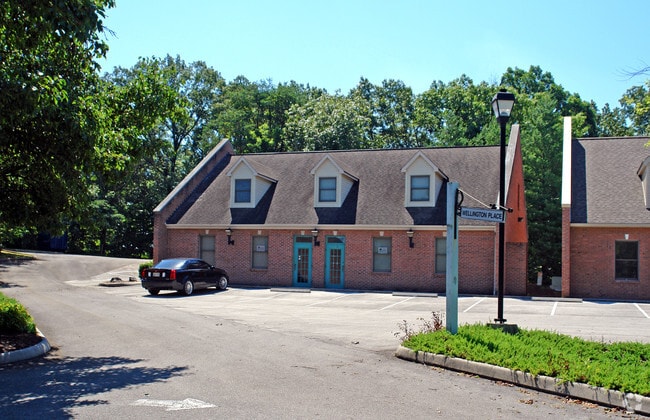
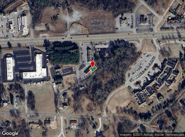
118 Parliament Dr
Knoxville, TN
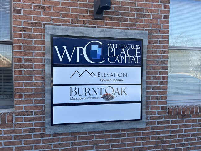
Wellington Place
058C-C-014.02
LOT 3BR 3BR UNIT 1 1947B
Officebuilding
Blount
X
Tennessee
47009C0139C
3br-u1
0
0.07 AC
2025
Blount County
011001
Knoxville
3,240 SF
DEMOGRAPHICS near 118 Parliament Dr
1 Mile
3 Mile
5 Mile
2024 Total Population
6,045
39,371
73,885
2029 Population
6,576
42,754
80,318
Pop Growth 2024-2029
+ 8.78%
+ 8.59%
+ 8.71%
Average Age
43
41
42
2024 Total Households
2,344
15,536
29,531
HH Growth 2024-2029
+ 8.87%
+ 8.68%
+ 8.77%
Median Household Inc
$71,465
$58,582
$60,976
Avg Household Size
2.40
2.40
2.40
2024 Avg HH Vehicles
2.00
2.00
2.00
Median Home Value
$240,071
$214,727
$226,147
Median Year Built
1984
1975
1983
Nearby Places
- Restaurants
- Banks
- Shops
- Fitness
- Groceries
PUBLIC TRANSPORTATION
AIRPORT
McGhee Tyson
DRIVE
WALK
Distance
McGhee Tyson
17 min
9.4 mi
Nearby Properties
Address
Land Use
TOTAL SIZE
Lot Size
Zoning
Address
Land Use
TOTAL SIZE
Lot Size
Zoning
194,621 SF
10.13 AC
CC
Address
Land Use
TOTAL SIZE
Lot Size
Zoning
75,124 SF
9.11 AC
E
Address
Land Use
TOTAL SIZE
Lot Size
Zoning
101,640 SF
7.41 AC
SPLIT
Address
Land Use
TOTAL SIZE
Lot Size
Zoning
88,949 SF
6.83 AC
CBDS
Address
Land Use
TOTAL SIZE
Lot Size
Zoning
23,916 SF
9.94 AC
E1
Address
Land Use
TOTAL SIZE
Lot Size
Zoning
138.59 AC
I
Address
Land Use
TOTAL SIZE
Lot Size
Zoning
74,071 SF
5.19 AC
HIC
Address
Land Use
TOTAL SIZE
Lot Size
Zoning
158,466 SF
14.78 AC
E1
Address
Land Use
TOTAL SIZE
Lot Size
Zoning
122,648 SF
0.10 AC
CBD
Address
Land Use
TOTAL SIZE
Lot Size
Zoning
45,913 SF
9.18 AC
RSF
Address
Land Use
TOTAL SIZE
Lot Size
Zoning
104,327 SF
26.19 AC
CC
Address
Land Use
TOTAL SIZE
Lot Size
Zoning
106,466 SF
2.65 AC
CC
Address
Land Use
TOTAL SIZE
Lot Size
Zoning
172.05 AC
G
Address
Land Use
TOTAL SIZE
Lot Size
Zoning
96,738 SF
23.34 AC
F
Address
Land Use
TOTAL SIZE
Lot Size
Zoning
42,996 SF
3.72 AC
WSCC
Address
Land Use
TOTAL SIZE
Lot Size
Zoning
103,689 SF
5.12 AC
R
Address
Land Use
TOTAL SIZE
Lot Size
Zoning
143,868 SF
5.50 AC
R
Address
Land Use
TOTAL SIZE
Lot Size
Zoning
28,298 SF
12.02 AC
S
Address
Land Use
TOTAL SIZE
Lot Size
Zoning
429,016 SF
29 AC
E
Address
Land Use
TOTAL SIZE
Lot Size
Zoning
68,441 SF
0.17 AC
R
Address
Land Use
TOTAL SIZE
Lot Size
Zoning
53,524 SF
6.95 AC
C
Address
Land Use
TOTAL SIZE
Lot Size
Zoning
66,127 SF
3.05 AC
CBDS
Address
Land Use
TOTAL SIZE
Lot Size
Zoning
45,730 SF
1.98 AC
B
Address
Land Use
TOTAL SIZE
Lot Size
Zoning
5,250 SF
7.09 AC
S
Address
Land Use
TOTAL SIZE
Lot Size
Zoning
124,412 SF
10.84 AC
HIC
Address
Land Use
TOTAL SIZE
Lot Size
Zoning
33,375 SF
4.20 AC
BT
Address
Land Use
TOTAL SIZE
Lot Size
Zoning
4,510 SF
13.72 AC
B
Address
Land Use
TOTAL SIZE
Lot Size
Zoning
43,026 SF
0.34 AC
CBD
Address
Land Use
TOTAL SIZE
Lot Size
Zoning
10,256 SF
37.47 AC
R
Address
Land Use
TOTAL SIZE
Lot Size
Zoning
49,296 SF
1.80 AC
R
The World's #1 Commercial Real Estate Marketplace
Connect with us
© 2025 CoStar Group
The information above has been obtained from sources believed reliable. While we do not doubt its accuracy we have not verified it and make no guarantee, warranty or representation about it. It is your responsibility to independently confirm its accuracy and completeness. Any projections, opinions, assumptions, or estimates used are for example only and do not represent the current or future performance of the property. The value of this transaction to you depends on tax and other factors which should be evaluated by your tax, financial, and legal advisors. You and your advisors should conduct a careful, independent investigation of the property to determine to your satisfaction the suitability of the property for your needs.