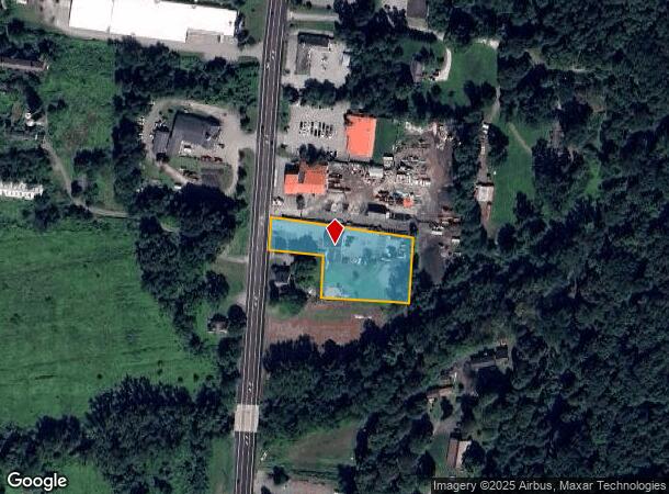
Property Record
118 Route 22, Pawling, NY 12564
NEARBY LISTINGS FOR SALE OR LEASE
Property Detail
118 Route 22
134089-7055-00-503941-0000
1.28 AC 1456 0762 1452 0050
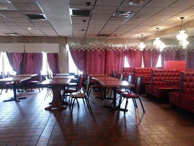
Officebuilding
Dutchess
A
New York
36027C0537E
503
2025
1.28 AC
2024
Fishkill
110004
Westchester/So Connecticut
2,000 SF
Dutchess County-Putnam County, NY
DEMOGRAPHICS near 118 Route 22
1 Mile
3 Mile
5 Mile
2024 Total Population
544
7,140
18,193
2029 Population
545
7,120
18,278
Pop Growth 2024-2029
+ 0.18%
(0.28%)
+ 0.47%
Average Age
47
44
44
2024 Total Households
227
2,490
6,417
HH Growth 2024-2029
+ 0.44%
(0.36%)
+ 0.45%
Median Household Inc
$85,227
$96,885
$109,554
Avg Household Size
2.30
2.50
2.60
2024 Avg HH Vehicles
2.00
2.00
2.00
Median Home Value
$387,499
$389,268
$408,821
Median Year Built
1985
1972
1971
Nearby Places
Map Layers
Map Styles
 Street
 Aerial
- Restaurants
- Banks
- Shops
- Fitness
- Groceries
PUBLIC TRANSPORTATION
COMMUTER RAIL
Patterson Station (Harlem Line - Metro-North Commuter Railroad Company (Metro-North))
DRIVE
WALK
Distance
Patterson Station (Harlem Line - Metro-North Commuter Railroad Company (Metro-North))
4 min
2.2 mi
Pawling Station (Harlem Line - Metro-North Commuter Railroad Company (Metro-North))
DRIVE
WALK
Distance
Pawling Station (Harlem Line - Metro-North Commuter Railroad Company (Metro-North))
5 min
2.7 mi
AIRPORT
New York Stewart International
DRIVE
WALK
Distance
New York Stewart International
52 min
36.5 mi
Freight Ports
Port of New Haven
DRIVE
WALK
Distance
Port of New Haven
78 min
50.5 mi
SALE & LEASE HISTORY
LISTING DATE
SALE/LEASE

Jun 08, 2017
For Sale
Nearby Properties
Address
Land Use
TOTAL SIZE
Lot Size
Zoning
Address
Land Use
TOTAL SIZE
Lot Size
Zoning
1,498,293 SF
361.91 AC
R4
Address
Land Use
TOTAL SIZE
Lot Size
Zoning
100.90 AC
R1
Address
Land Use
TOTAL SIZE
Lot Size
Zoning
12,064 SF
12.10 AC
C1
Address
Land Use
TOTAL SIZE
Lot Size
Zoning
84,651 SF
22.01 AC
C1
Address
Land Use
TOTAL SIZE
Lot Size
Zoning
129,961 SF
31.51 AC
C1
Address
Land Use
TOTAL SIZE
Lot Size
Zoning
77,537 SF
19.41 AC
R1
Address
Land Use
TOTAL SIZE
Lot Size
Zoning
12,871 SF
277.38 AC
R4
Address
Land Use
TOTAL SIZE
Lot Size
Zoning
19,768 SF
2.70 AC
GB
Address
Land Use
TOTAL SIZE
Lot Size
Zoning
79,989 SF
8.40 AC
R1
Address
Land Use
TOTAL SIZE
Lot Size
Zoning
6.43 AC
R2
Address
Land Use
TOTAL SIZE
Lot Size
Zoning
50,339 SF
14.96 AC
C1
Address
Land Use
TOTAL SIZE
Lot Size
Zoning
22,670 SF
10.58 AC
C1
Address
Land Use
TOTAL SIZE
Lot Size
Zoning
29,220 SF
23.83 AC
C1
Address
Land Use
TOTAL SIZE
Lot Size
Zoning
5.54 AC
Address
Land Use
TOTAL SIZE
Lot Size
Zoning
24,550 SF
2.02 AC
GB
Address
Land Use
TOTAL SIZE
Lot Size
Zoning
32.64 AC
R1
Address
Land Use
TOTAL SIZE
Lot Size
Zoning
17,792 SF
8.52 AC
R1
Address
Land Use
TOTAL SIZE
Lot Size
Zoning
4.47 AC
Address
Land Use
TOTAL SIZE
Lot Size
Zoning
5,070 SF
76 AC
CD-R5
Address
Land Use
TOTAL SIZE
Lot Size
Zoning
604.69 AC
R4
Address
Land Use
TOTAL SIZE
Lot Size
Zoning
21.57 AC
I-1
Address
Land Use
TOTAL SIZE
Lot Size
Zoning
0.23 AC
R4
Address
Land Use
TOTAL SIZE
Lot Size
Zoning
1.26 AC
GB
Address
Land Use
TOTAL SIZE
Lot Size
Zoning
3,232 SF
10.90 AC
CD-R5
Address
Land Use
TOTAL SIZE
Lot Size
Zoning
290.21 AC
R4
Address
Land Use
TOTAL SIZE
Lot Size
Zoning
96.55 AC
R4
Address
Land Use
TOTAL SIZE
Lot Size
Zoning
5.78 AC
I-1
Address
Land Use
TOTAL SIZE
Lot Size
Zoning
237.25 AC
R4
Address
Land Use
TOTAL SIZE
Lot Size
Zoning
24,590 SF
421.13 AC
R-4
Address
Land Use
TOTAL SIZE
Lot Size
Zoning
12.80 AC
VRD
The World's #1 Commercial Real Estate Marketplace
Connect with us
© 2025 CoStar Group
The information above has been obtained from sources believed reliable. While we do not doubt its accuracy we have not verified it and make no guarantee, warranty or representation about it. It is your responsibility to independently confirm its accuracy and completeness. Any projections, opinions, assumptions, or estimates used are for example only and do not represent the current or future performance of the property. The value of this transaction to you depends on tax and other factors which should be evaluated by your tax, financial, and legal advisors. You and your advisors should conduct a careful, independent investigation of the property to determine to your satisfaction the suitability of the property for your needs.