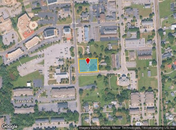
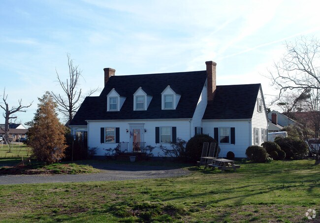
Property Record
118 Saint Marys Ave, La Plata, MD 20646

NEARBY LISTINGS FOR SALE OR LEASE
Property Detail
118 Saint Marys Ave
01-004646
La Plata
Taxexempt
.644 AC ST MARYS AVE LA PLATA
X
Charles
24017C0188C
Maryland
2023
0.66 AC
2025
Charles County
851004
Washington, DC
2,034 SF
Washington-Arlington-Alexandria, DC-VA-MD-WV
DEMOGRAPHICS near 118 Saint Marys Ave
1 Mile
3 Mile
5 Mile
2024 Total Population
6,471
15,727
30,903
2029 Population
6,833
16,519
32,481
Pop Growth 2024-2029
+ 5.59%
+ 5.04%
+ 5.11%
Average Age
40
41
40
2024 Total Households
2,383
5,682
11,079
HH Growth 2024-2029
+ 5.67%
+ 5.09%
+ 5.11%
Median Household Inc
$98,714
$110,569
$113,483
Avg Household Size
2.60
2.70
2.70
2024 Avg HH Vehicles
2.00
2.00
2.00
Median Home Value
$367,487
$393,096
$404,441
Median Year Built
1998
1989
1996
Nearby Places
Map Layers
Map Styles
 Street
 Aerial
- Restaurants
- Banks
- Shops
- Fitness
- Groceries
PUBLIC TRANSPORTATION
AIRPORT
Ronald Reagan Washington Ntl
DRIVE
WALK
Distance
Ronald Reagan Washington Ntl
59 min
32.0 mi
SALE & LEASE HISTORY
LISTING DATE
SALE/LEASE

Sep 23, 2016
For Sale
Nearby Properties
Address
Land Use
TOTAL SIZE
Lot Size
Zoning
Address
Land Use
TOTAL SIZE
Lot Size
Zoning
173.69 AC
RC
Address
Land Use
TOTAL SIZE
Lot Size
Zoning
315,662 SF
134.30 AC
PL
Address
Land Use
TOTAL SIZE
Lot Size
Zoning
150,480 SF
4.60 AC
CH
Address
Land Use
TOTAL SIZE
Lot Size
Zoning
113,605 SF
20.59 AC
CH
Address
Land Use
TOTAL SIZE
Lot Size
Zoning
6.54 AC
PL
Address
Land Use
TOTAL SIZE
Lot Size
Zoning
80,682 SF
11.35 AC
C-H
Address
Land Use
TOTAL SIZE
Lot Size
Zoning
98,995 SF
16.83 AC
NCX
Address
Land Use
TOTAL SIZE
Lot Size
Zoning
53,638 SF
3.76 AC
MUD-3
Address
Land Use
TOTAL SIZE
Lot Size
Zoning
129,001 SF
11.64 AC
C-H
Address
Land Use
TOTAL SIZE
Lot Size
Zoning
15.22 AC
TDX
Address
Land Use
TOTAL SIZE
Lot Size
Zoning
166,188 SF
27.99 AC
IG
Address
Land Use
TOTAL SIZE
Lot Size
Zoning
137,862 SF
18.10 AC
CH
Address
Land Use
TOTAL SIZE
Lot Size
Zoning
106,711 SF
92.18 AC
PL
Address
Land Use
TOTAL SIZE
Lot Size
Zoning
65,890 SF
6.70 AC
PL
Address
Land Use
TOTAL SIZE
Lot Size
Zoning
35,976 SF
3.97 AC
CH
Address
Land Use
TOTAL SIZE
Lot Size
Zoning
62,127 SF
37.47 AC
PL
Address
Land Use
TOTAL SIZE
Lot Size
Zoning
44,620 SF
9 AC
R-10
Address
Land Use
TOTAL SIZE
Lot Size
Zoning
70,913 SF
6.02 AC
CH
Address
Land Use
TOTAL SIZE
Lot Size
Zoning
75,375 SF
4.34 AC
C-B
Address
Land Use
TOTAL SIZE
Lot Size
Zoning
140,188 SF
15 AC
CH
Address
Land Use
TOTAL SIZE
Lot Size
Zoning
98,400 SF
1.89 AC
PL
Address
Land Use
TOTAL SIZE
Lot Size
Zoning
89,000 SF
2.13 AC
CB
Address
Land Use
TOTAL SIZE
Lot Size
Zoning
68,859 SF
3.75 AC
MUD-3
Address
Land Use
TOTAL SIZE
Lot Size
Zoning
3,696 SF
578.77 AC
MUD-3
Address
Land Use
TOTAL SIZE
Lot Size
Zoning
60,310 SF
2.99 AC
LI
Address
Land Use
TOTAL SIZE
Lot Size
Zoning
39,936 SF
6.24 AC
LI
Address
Land Use
TOTAL SIZE
Lot Size
Zoning
78,798 SF
5.64 AC
R3
Address
Land Use
TOTAL SIZE
Lot Size
Zoning
38,228 SF
21.77 AC
PL
Address
Land Use
TOTAL SIZE
Lot Size
Zoning
39,786 SF
1.53 AC
C-B
Address
Land Use
TOTAL SIZE
Lot Size
Zoning
49,790 SF
8.28 AC
C-H
The World's #1 Commercial Real Estate Marketplace
Connect with us
© 2025 CoStar Group
The information above has been obtained from sources believed reliable. While we do not doubt its accuracy we have not verified it and make no guarantee, warranty or representation about it. It is your responsibility to independently confirm its accuracy and completeness. Any projections, opinions, assumptions, or estimates used are for example only and do not represent the current or future performance of the property. The value of this transaction to you depends on tax and other factors which should be evaluated by your tax, financial, and legal advisors. You and your advisors should conduct a careful, independent investigation of the property to determine to your satisfaction the suitability of the property for your needs.