Property Record
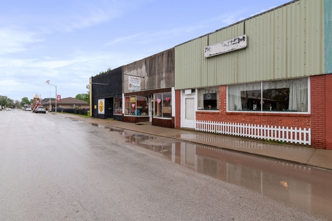
118 W 2Nd St, Norborne, MO 64668

NEARBY LISTINGS FOR SALE OR LEASE
-
-
View all Norborne listings for sale on LoopNet.com
Property Detail
118 W 2Nd St
17-6.0-23-2-04-052
Original Town To Norb
Warehouse
ORIGINAL TOWN TO NORB LOT5;BLK16
X
Carroll
29033C0370C
Missouri
2024
0.06 AC
2025
Missouri North Area
960200
Other Market Areas
2,225 SF
DEMOGRAPHICS near 118 W 2Nd St
1 mile
3 mile
5 mile
2024 Total Population
772
841
891
2029 Population
790
856
902
Pop Growth 2024-2029
+ 2.33%
+ 1.78%
+ 1.23%
Average Age
43
43
43
2024 Total Households
337
367
388
HH Growth 2024-2029
+ 2.08%
+ 1.63%
+ 1.29%
Median Household Inc
$57,543
$57,457
$57,542
Avg Household Size
2.30
2.30
2.30
2024 Avg HH Vehicles
2.00
2.00
2.00
Median Home Value
$77,743
$78,976
$80,600
Median Year Built
1969
1967
1967
Nearby Places
Map Layers
Map Styles
 Street
 Aerial
Transit
 Traffic
 Biking
Places
Listings with unknown addresses are not visible on the map
- Restaurants
- Banks
- Shops
- Fitness
- Groceries
SALE & LEASE HISTORY
LISTING DATE
SALE/LEASE

Nov 19, 2024
For Sale
Nearby Properties
Address
Land Use
TOTAL SIZE
Lot Size
Zoning
Address
Land Use
TOTAL SIZE
Lot Size
Zoning
1,014 SF
49 AC
Address
Land Use
TOTAL SIZE
Lot Size
Zoning
243 AC
Address
Land Use
TOTAL SIZE
Lot Size
Zoning
8.19 AC
Address
Land Use
TOTAL SIZE
Lot Size
Zoning
3,564 SF
0.41 AC
Address
Land Use
TOTAL SIZE
Lot Size
Zoning
2,135 SF
6.14 AC
Address
Land Use
TOTAL SIZE
Lot Size
Zoning
2,539 SF
0.69 AC
Address
Land Use
TOTAL SIZE
Lot Size
Zoning
1,958 SF
5 AC
Address
Land Use
TOTAL SIZE
Lot Size
Zoning
2,106 SF
0.48 AC
Address
Land Use
TOTAL SIZE
Lot Size
Zoning
1,498 SF
0.32 AC
Address
Land Use
TOTAL SIZE
Lot Size
Zoning
0.10 AC
Address
Land Use
TOTAL SIZE
Lot Size
Zoning
2,417 SF
0.57 AC
Address
Land Use
TOTAL SIZE
Lot Size
Zoning
1,916 SF
13.40 AC
Address
Land Use
TOTAL SIZE
Lot Size
Zoning
413.70 AC
Address
Land Use
TOTAL SIZE
Lot Size
Zoning
1,654 SF
0.28 AC
Address
Land Use
TOTAL SIZE
Lot Size
Zoning
3,138 SF
0.48 AC
Address
Land Use
TOTAL SIZE
Lot Size
Zoning
14.12 AC
Address
Land Use
TOTAL SIZE
Lot Size
Zoning
2,454 SF
229 AC
Address
Land Use
TOTAL SIZE
Lot Size
Zoning
2,783 SF
0.52 AC
Address
Land Use
TOTAL SIZE
Lot Size
Zoning
0.34 AC
Address
Land Use
TOTAL SIZE
Lot Size
Zoning
2,571 SF
4 AC
Address
Land Use
TOTAL SIZE
Lot Size
Zoning
Address
Land Use
TOTAL SIZE
Lot Size
Zoning
2,339 SF
115 AC
Address
Land Use
TOTAL SIZE
Lot Size
Zoning
3,461 SF
5 AC
Address
Land Use
TOTAL SIZE
Lot Size
Zoning
3,968 SF
3.20 AC
Address
Land Use
TOTAL SIZE
Lot Size
Zoning
2,346 SF
0.46 AC
Address
Land Use
TOTAL SIZE
Lot Size
Zoning
1,761 SF
184.40 AC
Address
Land Use
TOTAL SIZE
Lot Size
Zoning
Address
Land Use
TOTAL SIZE
Lot Size
Zoning
3,057 SF
0.62 AC
Address
Land Use
TOTAL SIZE
Lot Size
Zoning
1,627 SF
189.82 AC
The World's #1 Commercial Real Estate Marketplace
Connect with us
© 2026 CoStar Group
The information above has been obtained from sources believed reliable. While we do not doubt its accuracy we have not verified it and make no guarantee, warranty or representation about it. It is your responsibility to independently confirm its accuracy and completeness. Any projections, opinions, assumptions, or estimates used are for example only and do not represent the current or future performance of the property. The value of this transaction to you depends on tax and other factors which should be evaluated by your tax, financial, and legal advisors. You and your advisors should conduct a careful, independent investigation of the property to determine to your satisfaction the suitability of the property for your needs.