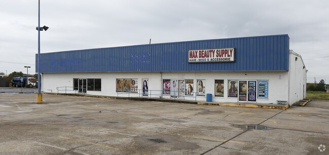
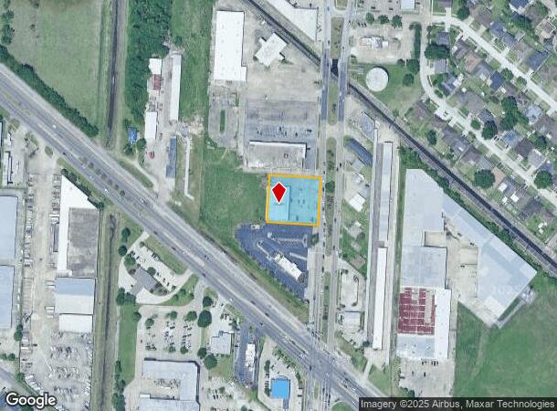
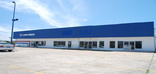
Property Record
1180 A-E Terry Pkwy, Terrytown, LA 70056
NEARBY LISTINGS FOR SALE OR LEASE
Property Detail
1180 A-E Terry Pkwy
New Orleans-Metairie, LA
Oakdale & Oakdale Farms Blks
0200001073
LOT 7-B-2B-2A BLK 7 SEC B OAKDALE
Realpropertynec
Jefferson
X
Louisiana
22051C0220F
7b2b
2024
0.76 AC
2024
Westbank
025003
New Orleans/Metairie/Kenner
DEMOGRAPHICS near 1180 A-E Terry Pkwy
1 Mile
3 Mile
5 Mile
2024 Total Population
18,122
103,572
219,726
2029 Population
17,307
99,190
211,583
Pop Growth 2024-2029
(4.50%)
(4.23%)
(3.71%)
Average Age
38
39
40
2024 Total Households
6,501
39,394
91,013
HH Growth 2024-2029
(4.71%)
(4.39%)
(3.66%)
Median Household Inc
$55,173
$51,436
$55,236
Avg Household Size
2.70
2.50
2.30
2024 Avg HH Vehicles
2.00
2.00
1.00
Median Home Value
$206,581
$198,498
$216,600
Median Year Built
1974
1975
1971
Nearby Places
Map Layers
Map Styles
 Street
 Aerial
- Restaurants
- Banks
- Shops
- Fitness
- Groceries
PUBLIC TRANSPORTATION
AIRPORT
Louis Armstrong New Orleans International
DRIVE
WALK
Distance
Louis Armstrong New Orleans International
32 min
21.7 mi
Nearby Properties
Address
Land Use
TOTAL SIZE
Lot Size
Zoning
Address
Land Use
TOTAL SIZE
Lot Size
Zoning
0.12 AC
Address
Land Use
TOTAL SIZE
Lot Size
Zoning
0.14 AC
Address
Land Use
TOTAL SIZE
Lot Size
Zoning
4.12 AC
Address
Land Use
TOTAL SIZE
Lot Size
Zoning
25.26 AC
Address
Land Use
TOTAL SIZE
Lot Size
Zoning
109,688 SF
8.77 AC
S-RM1
Address
Land Use
TOTAL SIZE
Lot Size
Zoning
23.90 AC
Address
Land Use
TOTAL SIZE
Lot Size
Zoning
14.40 AC
Address
Land Use
TOTAL SIZE
Lot Size
Zoning
140,772 SF
9.01 AC
S-RS
Address
Land Use
TOTAL SIZE
Lot Size
Zoning
3.55 AC
Address
Land Use
TOTAL SIZE
Lot Size
Zoning
12.79 AC
Address
Land Use
TOTAL SIZE
Lot Size
Zoning
14.69 AC
Address
Land Use
TOTAL SIZE
Lot Size
Zoning
Address
Land Use
TOTAL SIZE
Lot Size
Zoning
0.16 AC
Address
Land Use
TOTAL SIZE
Lot Size
Zoning
0.19 AC
Address
Land Use
TOTAL SIZE
Lot Size
Zoning
21.96 AC
MUCD
Address
Land Use
TOTAL SIZE
Lot Size
Zoning
10.14 AC
Address
Land Use
TOTAL SIZE
Lot Size
Zoning
0.78 AC
Address
Land Use
TOTAL SIZE
Lot Size
Zoning
0.14 AC
Address
Land Use
TOTAL SIZE
Lot Size
Zoning
2.84 AC
Address
Land Use
TOTAL SIZE
Lot Size
Zoning
Address
Land Use
TOTAL SIZE
Lot Size
Zoning
16.87 AC
R1A
Address
Land Use
TOTAL SIZE
Lot Size
Zoning
1.38 AC
Address
Land Use
TOTAL SIZE
Lot Size
Zoning
147,253 SF
9.95 AC
S-RM1
Address
Land Use
TOTAL SIZE
Lot Size
Zoning
16.84 AC
EC
Address
Land Use
TOTAL SIZE
Lot Size
Zoning
228,859 SF
23.59 AC
C-3
Address
Land Use
TOTAL SIZE
Lot Size
Zoning
42.23 AC
Address
Land Use
TOTAL SIZE
Lot Size
Zoning
8.11 AC
EC
Address
Land Use
TOTAL SIZE
Lot Size
Zoning
159,090 SF
23.56 AC
Address
Land Use
TOTAL SIZE
Lot Size
Zoning
Address
Land Use
TOTAL SIZE
Lot Size
Zoning
9.57 AC
The World's #1 Commercial Real Estate Marketplace
Connect with us
© 2026 CoStar Group
The information above has been obtained from sources believed reliable. While we do not doubt its accuracy we have not verified it and make no guarantee, warranty or representation about it. It is your responsibility to independently confirm its accuracy and completeness. Any projections, opinions, assumptions, or estimates used are for example only and do not represent the current or future performance of the property. The value of this transaction to you depends on tax and other factors which should be evaluated by your tax, financial, and legal advisors. You and your advisors should conduct a careful, independent investigation of the property to determine to your satisfaction the suitability of the property for your needs.