Property Record
1180 New Ballwin Oaks Dr, Ballwin, MO 63021

Property Detail
1180 New Ballwin Oaks Dr
St. Louis, MO-IL
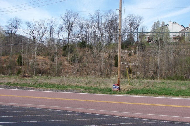
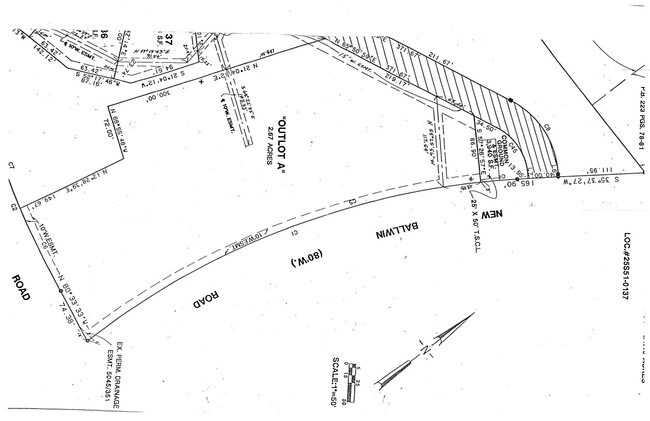
NEW BALLWIN OAKS OUTLOT A
25S-52-0565
ST. LOUIS
Vacantlandnec
Missouri
93C-8
a
B and X Area of moderate flood hazard, usually the area between the limits of the 100-year and 500-year floods.
2.67 AC
2024
West County
2025
St. Louis
217944
NEARBY LISTINGS FOR SALE OR LEASE
-
-
View all Ballwin listings for sale on LoopNet.com
DEMOGRAPHICS near 1180 New Ballwin Oaks Dr
1 mile
3 mile
5 mile
2025 Total Population
6,036
50,590
131,326
2030 Population
5,943
49,811
129,278
Pop Growth 2025-2030
(1.54%)
(1.54%)
(1.56%)
Average Age
43
41
42
2025 Total Households
2,192
19,917
51,487
HH Growth 2025-2030
(1.60%)
(1.52%)
(1.58%)
Median Household Inc
$136,863
$116,334
$121,017
Avg Household Size
2.70
2.50
2.50
2025 Avg HH Vehicles
2.00
2.00
2.00
Median Home Value
$417,445
$339,696
$379,656
Median Year Built
1992
1982
1982
Nearby Places
Map Layers
Map Styles
 Street
 Aerial
Transit
 Traffic
 Biking
Places
Listings with unknown addresses are not visible on the map
- Restaurants
- Banks
- Shops
- Fitness
- Groceries
PUBLIC TRANSPORTATION
COMMUTER RAIL
Drive
Walk
Distance
20 min
9.6 mi
AIRPORT
St Louis Lambert International
Drive
Walk
Distance
St Louis Lambert International
41 min
26.6 mi
Nearby Properties
Address
Land Use
TOTAL SIZE
Lot Size
Zoning
Address
Land Use
TOTAL SIZE
Lot Size
Zoning
96.62 AC
R3
Address
Land Use
TOTAL SIZE
Lot Size
Zoning
633,127 SF
51.20 AC
NU
Address
Land Use
TOTAL SIZE
Lot Size
Zoning
403,166 SF
23.17 AC
R4
Address
Land Use
TOTAL SIZE
Lot Size
Zoning
19.25 AC
55INSTU
Address
Land Use
TOTAL SIZE
Lot Size
Zoning
223,598 SF
13.95 AC
93C-1
Address
Land Use
TOTAL SIZE
Lot Size
Zoning
175,448 SF
6.95 AC
Address
Land Use
TOTAL SIZE
Lot Size
Zoning
153,489 SF
13.01 AC
93C-1
Address
Land Use
TOTAL SIZE
Lot Size
Zoning
2,154 SF
13.19 AC
S
Address
Land Use
TOTAL SIZE
Lot Size
Zoning
1,782 SF
120.27 AC
NU
Address
Land Use
TOTAL SIZE
Lot Size
Zoning
220,288 SF
11.09 AC
93R-4
Address
Land Use
TOTAL SIZE
Lot Size
Zoning
191,316 SF
7.61 AC
R4
Address
Land Use
TOTAL SIZE
Lot Size
Zoning
181,790 SF
16.64 AC
R4
Address
Land Use
TOTAL SIZE
Lot Size
Zoning
247,511 SF
31.03 AC
19M-1
Address
Land Use
TOTAL SIZE
Lot Size
Zoning
74,614 SF
8.05 AC
93C-1
Address
Land Use
TOTAL SIZE
Lot Size
Zoning
27.05 AC
R1
Address
Land Use
TOTAL SIZE
Lot Size
Zoning
5,641 SF
9.41 AC
94R-1
Address
Land Use
TOTAL SIZE
Lot Size
Zoning
70,267 SF
11.61 AC
19C-3
Address
Land Use
TOTAL SIZE
Lot Size
Zoning
7,250 SF
80.06 AC
R
Address
Land Use
TOTAL SIZE
Lot Size
Zoning
120,760 SF
11.10 AC
19C-3
Address
Land Use
TOTAL SIZE
Lot Size
Zoning
136,009 SF
12.35 AC
93C-1
Address
Land Use
TOTAL SIZE
Lot Size
Zoning
97,285 SF
13.66 AC
19R-1
Address
Land Use
TOTAL SIZE
Lot Size
Zoning
125,664 SF
12.38 AC
94R-6
Address
Land Use
TOTAL SIZE
Lot Size
Zoning
20.70 AC
NU
Address
Land Use
TOTAL SIZE
Lot Size
Zoning
115,781 SF
7.87 AC
R4
Address
Land Use
TOTAL SIZE
Lot Size
Zoning
111,708 SF
5.14 AC
93R-4
Address
Land Use
TOTAL SIZE
Lot Size
Zoning
50,422 SF
5.94 AC
93C-1
Address
Land Use
TOTAL SIZE
Lot Size
Zoning
99,100 SF
3.74 AC
19R-1
Address
Land Use
TOTAL SIZE
Lot Size
Zoning
67,841 SF
12.79 AC
R2
Address
Land Use
TOTAL SIZE
Lot Size
Zoning
6.70 AC
R2
Address
Land Use
TOTAL SIZE
Lot Size
Zoning
141,009 SF
13.76 AC
R-1
The World's #1 Commercial Real Estate Marketplace
Connect with us
© 2026 CoStar Group
The information above has been obtained from sources believed reliable. While we do not doubt its accuracy we have not verified it and make no guarantee, warranty or representation about it. It is your responsibility to independently confirm its accuracy and completeness. Any projections, opinions, assumptions, or estimates used are for example only and do not represent the current or future performance of the property. The value of this transaction to you depends on tax and other factors which should be evaluated by your tax, financial, and legal advisors. You and your advisors should conduct a careful, independent investigation of the property to determine to your satisfaction the suitability of the property for your needs.