No Photo
Property Record
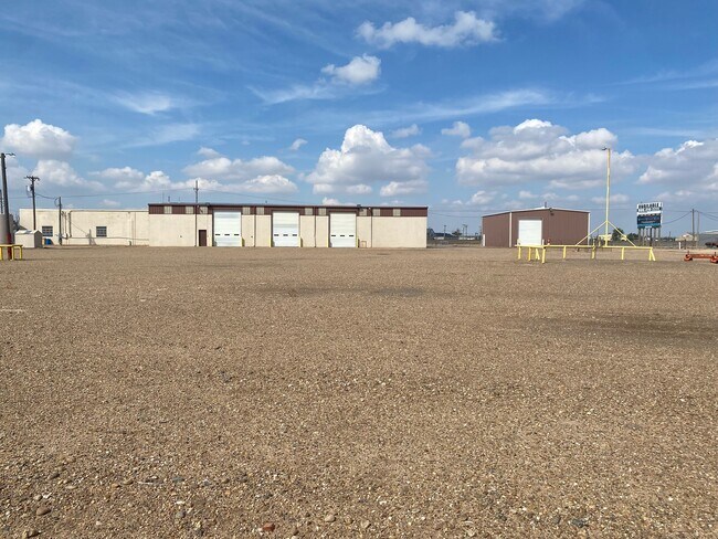
11800 Us Highway 60, Pampa, TX 79065


NEARBY LISTINGS FOR SALE OR LEASE
Property Detail
11800 Us Highway 60
111500251585030000000
SUBURBS 158 5.646 ACS
Industrialgeneral
Gray
X
Texas
48179C0040C
5.64 AC
2025
Panhandle Area
2025
Other Market Areas
950800
Pampa, TX
43,204 SF
DEMOGRAPHICS near 11800 Us Highway 60
1 Mile
3 Mile
5 Mile
2024 Total Population
1,357
14,448
18,168
2029 Population
1,414
14,467
17,977
Pop Growth 2024-2029
+ 4.20%
+ 0.13%
(1.05%)
Average Age
38
39
39
2024 Total Households
515
5,711
7,219
HH Growth 2024-2029
+ 4.27%
+ 0.05%
(1.11%)
Median Household Inc
$33,014
$42,606
$48,904
Avg Household Size
2.60
2.50
2.50
2024 Avg HH Vehicles
2.00
2.00
2.00
Median Home Value
$54,178
$78,275
$93,210
Median Year Built
1957
1960
1961
Nearby Places
Map Layers
Map Styles
 Street
 Aerial
- Restaurants
- Banks
- Shops
- Fitness
- Groceries
SALE & LEASE HISTORY
LISTING DATE
SALE/LEASE

Oct 21, 2022
For Sale
Jul 28, 2023
For Sale
Feb 21, 2023
For Lease
Nearby Properties
Address
Land Use
TOTAL SIZE
Lot Size
Zoning
Address
Land Use
TOTAL SIZE
Lot Size
Zoning
381,829 SF
42.18 AC
Address
Land Use
TOTAL SIZE
Lot Size
Zoning
265,197 SF
7.82 AC
Address
Land Use
TOTAL SIZE
Lot Size
Zoning
210,169 SF
12.54 AC
Address
Land Use
TOTAL SIZE
Lot Size
Zoning
227,269 SF
85.03 AC
Address
Land Use
TOTAL SIZE
Lot Size
Zoning
8 SF
2.48 AC
Address
Land Use
TOTAL SIZE
Lot Size
Zoning
279,844 SF
6.94 AC
Address
Land Use
TOTAL SIZE
Lot Size
Zoning
200,845 SF
5.51 AC
Address
Land Use
TOTAL SIZE
Lot Size
Zoning
34,797 SF
0.96 AC
Address
Land Use
TOTAL SIZE
Lot Size
Zoning
83,966 SF
11.84 AC
Address
Land Use
TOTAL SIZE
Lot Size
Zoning
51,703 SF
3.92 AC
Address
Land Use
TOTAL SIZE
Lot Size
Zoning
54,091 SF
7.67 AC
Address
Land Use
TOTAL SIZE
Lot Size
Zoning
56,977 SF
8.15 AC
Address
Land Use
TOTAL SIZE
Lot Size
Zoning
38,210 SF
18.16 AC
Address
Land Use
TOTAL SIZE
Lot Size
Zoning
190,394 SF
6.40 AC
Address
Land Use
TOTAL SIZE
Lot Size
Zoning
2,589 SF
0.96 AC
Address
Land Use
TOTAL SIZE
Lot Size
Zoning
86,474 SF
1.97 AC
Address
Land Use
TOTAL SIZE
Lot Size
Zoning
69,382 SF
1.56 AC
Address
Land Use
TOTAL SIZE
Lot Size
Zoning
70,855 SF
2 AC
Address
Land Use
TOTAL SIZE
Lot Size
Zoning
113,495 SF
2.71 AC
Address
Land Use
TOTAL SIZE
Lot Size
Zoning
58,736 SF
7.54 AC
Address
Land Use
TOTAL SIZE
Lot Size
Zoning
15,087 SF
0.32 AC
Address
Land Use
TOTAL SIZE
Lot Size
Zoning
89,835 SF
1.74 AC
Address
Land Use
TOTAL SIZE
Lot Size
Zoning
63,187 SF
5.07 AC
Address
Land Use
TOTAL SIZE
Lot Size
Zoning
39,746 SF
3.44 AC
Address
Land Use
TOTAL SIZE
Lot Size
Zoning
42,747 SF
5.22 AC
Address
Land Use
TOTAL SIZE
Lot Size
Zoning
135,179 SF
14.35 AC
Address
Land Use
TOTAL SIZE
Lot Size
Zoning
38,372 SF
17.55 AC
Address
Land Use
TOTAL SIZE
Lot Size
Zoning
28,998 SF
1.68 AC
Address
Land Use
TOTAL SIZE
Lot Size
Zoning
66,375 SF
4.30 AC
Address
Land Use
TOTAL SIZE
Lot Size
Zoning
69,856 SF
1.12 AC
The World's #1 Commercial Real Estate Marketplace
Connect with us
© 2025 CoStar Group
The information above has been obtained from sources believed reliable. While we do not doubt its accuracy we have not verified it and make no guarantee, warranty or representation about it. It is your responsibility to independently confirm its accuracy and completeness. Any projections, opinions, assumptions, or estimates used are for example only and do not represent the current or future performance of the property. The value of this transaction to you depends on tax and other factors which should be evaluated by your tax, financial, and legal advisors. You and your advisors should conduct a careful, independent investigation of the property to determine to your satisfaction the suitability of the property for your needs.