Property Record
11801 E Loop 1604 N, Universal City, TX 78148
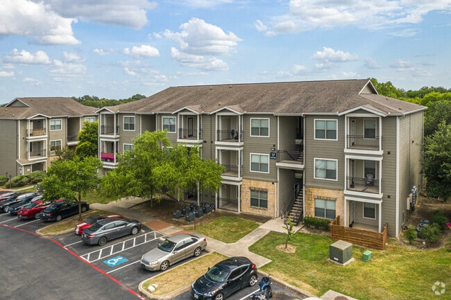


Property Detail
11801 E Loop 1604 N
San Antonio-New Braunfels, TX
CB 5053R BLK 12 LOT 1 ABS 745 2025 SPLIT PER DEED 20240200157/// PLAT 9566/23-24//2014-MERGE PER CR# 32103
05053-912-0010
BEXAR
Multifamilydwelling
Texas
AE The base floodplain where base flood elevations are provided. AE Zones are now used on new format FIRMs instead of A1-A30 Zones.
1
2024
20.22 AC
2025
Northeast Side
121604
San Antonio
251,707 SF
NEARBY LISTINGS FOR SALE OR LEASE
-
-
View all Universal City listings for sale on LoopNet.com
DEMOGRAPHICS near 11801 E Loop 1604 N
1 mile
3 mile
5 mile
2025 Total Population
10,581
91,382
236,554
2030 Population
11,041
96,632
251,281
Pop Growth 2025-2030
+ 4.35%
+ 5.75%
+ 6.23%
Average Age
37
38
38
2025 Total Households
4,100
33,850
84,820
HH Growth 2025-2030
+ 4.54%
+ 5.90%
+ 6.41%
Median Household Inc
$74,856
$82,033
$82,888
Avg Household Size
2.50
2.70
2.70
2025 Avg HH Vehicles
2.00
2.00
2.00
Median Home Value
$263,146
$255,066
$262,440
Median Year Built
1996
1993
1996
Nearby Places
Map Layers
Map Styles
 Street
 Aerial
Transit
 Traffic
 Biking
Places
Listings with unknown addresses are not visible on the map
- Restaurants
- Banks
- Shops
- Fitness
- Groceries
PUBLIC TRANSPORTATION
AIRPORT
San Antonio International
Drive
Walk
Distance
San Antonio International
21 min
12.1 mi
Freight Ports
Calhoun Port
Drive
Walk
Distance
Calhoun Port
172 min
143.9 mi
Nearby Properties
Address
Land Use
TOTAL SIZE
Lot Size
Zoning
Address
Land Use
TOTAL SIZE
Lot Size
Zoning
538,168 SF
176.13 AC
Address
Land Use
TOTAL SIZE
Lot Size
Zoning
727,299 SF
47.68 AC
Address
Land Use
TOTAL SIZE
Lot Size
Zoning
402,370 SF
45.49 AC
Address
Land Use
TOTAL SIZE
Lot Size
Zoning
116.47 AC
Address
Land Use
TOTAL SIZE
Lot Size
Zoning
350,805 SF
20.85 AC
Address
Land Use
TOTAL SIZE
Lot Size
Zoning
347,943 SF
10.07 AC
Address
Land Use
TOTAL SIZE
Lot Size
Zoning
223,185 SF
16.85 AC
Address
Land Use
TOTAL SIZE
Lot Size
Zoning
199,756 SF
19.75 AC
Address
Land Use
TOTAL SIZE
Lot Size
Zoning
281,145 SF
29.26 AC
Address
Land Use
TOTAL SIZE
Lot Size
Zoning
242,267 SF
15.77 AC
Address
Land Use
TOTAL SIZE
Lot Size
Zoning
251,110 SF
12.26 AC
Address
Land Use
TOTAL SIZE
Lot Size
Zoning
240,077 SF
16.92 AC
Address
Land Use
TOTAL SIZE
Lot Size
Zoning
218,379 SF
9.65 AC
Address
Land Use
TOTAL SIZE
Lot Size
Zoning
277,887 SF
14.14 AC
Address
Land Use
TOTAL SIZE
Lot Size
Zoning
490,283 SF
38.97 AC
Address
Land Use
TOTAL SIZE
Lot Size
Zoning
229,077 SF
10.06 AC
Address
Land Use
TOTAL SIZE
Lot Size
Zoning
200,940 SF
10.31 AC
Address
Land Use
TOTAL SIZE
Lot Size
Zoning
245,993 SF
23.82 AC
Address
Land Use
TOTAL SIZE
Lot Size
Zoning
198,868 SF
15.15 AC
Address
Land Use
TOTAL SIZE
Lot Size
Zoning
271,018 SF
13.75 AC
Address
Land Use
TOTAL SIZE
Lot Size
Zoning
172,080 SF
17 AC
Address
Land Use
TOTAL SIZE
Lot Size
Zoning
190,134 SF
10.54 AC
Address
Land Use
TOTAL SIZE
Lot Size
Zoning
154,641 SF
9.07 AC
Address
Land Use
TOTAL SIZE
Lot Size
Zoning
156,381 SF
8.29 AC
Address
Land Use
TOTAL SIZE
Lot Size
Zoning
113,091 SF
12.60 AC
Address
Land Use
TOTAL SIZE
Lot Size
Zoning
190,717 SF
9.99 AC
Address
Land Use
TOTAL SIZE
Lot Size
Zoning
145,811 SF
10.36 AC
Address
Land Use
TOTAL SIZE
Lot Size
Zoning
342,612 SF
28.49 AC
Address
Land Use
TOTAL SIZE
Lot Size
Zoning
90,442 SF
10.21 AC
The World's #1 Commercial Real Estate Marketplace
Connect with us
© 2026 CoStar Group
The information above has been obtained from sources believed reliable. While we do not doubt its accuracy we have not verified it and make no guarantee, warranty or representation about it. It is your responsibility to independently confirm its accuracy and completeness. Any projections, opinions, assumptions, or estimates used are for example only and do not represent the current or future performance of the property. The value of this transaction to you depends on tax and other factors which should be evaluated by your tax, financial, and legal advisors. You and your advisors should conduct a careful, independent investigation of the property to determine to your satisfaction the suitability of the property for your needs.