Property Record
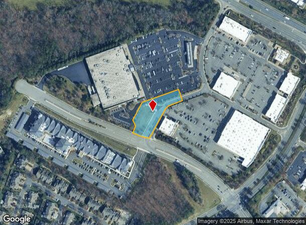
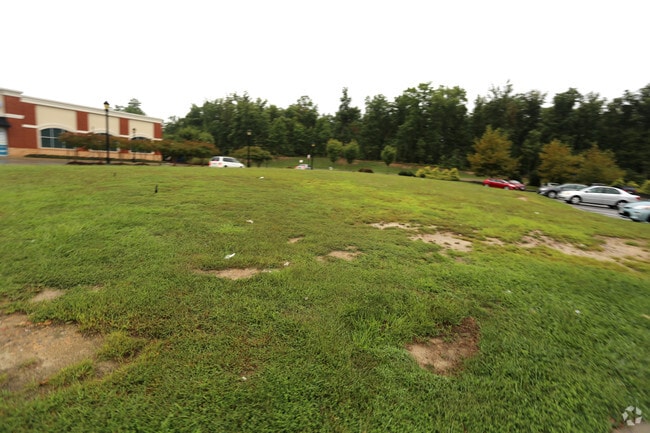
11881 W Broad St, Henrico, VA 23233
Current Lease Availabilities
NEARBY LISTINGS FOR SALE OR LEASE
Property Detail
11881 W Broad St
736-762-2221
00360A0000 0049; W BROAD ST AC .928 PAR C
Commercialacreage
Henrico
X
Virginia
51085C0290C
0.93 AC
2025
Short Pump
2025
Richmond VA
200141
Richmond, VA
DEMOGRAPHICS near 11881 W Broad St
1 Mile
3 Mile
5 Mile
2024 Total Population
11,272
65,441
138,097
2029 Population
11,440
65,716
138,911
Pop Growth 2024-2029
+ 1.49%
+ 0.42%
+ 0.59%
Average Age
38
40
40
2024 Total Households
4,083
24,808
54,193
HH Growth 2024-2029
+ 1.27%
+ 0.46%
+ 0.66%
Median Household Inc
$133,521
$123,586
$103,952
Avg Household Size
2.70
2.60
2.50
2024 Avg HH Vehicles
2.00
2.00
2.00
Median Home Value
$555,712
$459,727
$428,333
Median Year Built
1997
1995
1990
Nearby Places
Map Layers
Map Styles
 Street
 Aerial
- Restaurants
- Banks
- Shops
- Fitness
- Groceries
PUBLIC TRANSPORTATION
COMMUTER RAIL
Richmond Staples Mill Road Amtrak Station (Carolinian - Amtrak, Northeast Regional - Amtrak, Palmetto - Amtrak, Silver Meteor - Amtrak)
DRIVE
WALK
Distance
Richmond Staples Mill Road Amtrak Station (Carolinian - Amtrak, Northeast Regional - Amtrak, Palmetto - Amtrak, Silver Meteor - Amtrak)
14 min
8.9 mi
AIRPORT
Richmond International
DRIVE
WALK
Distance
Richmond International
34 min
22.9 mi
Freight Ports
Virginia Port Authority - Richmond
DRIVE
WALK
Distance
Virginia Port Authority - Richmond
32 min
21.2 mi
Nearby Properties
Address
Land Use
TOTAL SIZE
Lot Size
Zoning
Address
Land Use
TOTAL SIZE
Lot Size
Zoning
10,290 SF
56.53 AC
B-3C
Address
Land Use
TOTAL SIZE
Lot Size
Zoning
93.75 AC
M1-INDUS/L
Address
Land Use
TOTAL SIZE
Lot Size
Zoning
632,549 SF
90.12 AC
R-6
Address
Land Use
TOTAL SIZE
Lot Size
Zoning
37.36 AC
R-5C
Address
Land Use
TOTAL SIZE
Lot Size
Zoning
227,483 SF
12.10 AC
M1-INDUS/L
Address
Land Use
TOTAL SIZE
Lot Size
Zoning
112,224 SF
20.53 AC
MIXE
Address
Land Use
TOTAL SIZE
Lot Size
Zoning
57,104 SF
0.02 AC
UMUC
Address
Land Use
TOTAL SIZE
Lot Size
Zoning
403,784 SF
40.74 AC
MIXE
Address
Land Use
TOTAL SIZE
Lot Size
Zoning
417,042 SF
49.96 AC
O-3C
Address
Land Use
TOTAL SIZE
Lot Size
Zoning
3,077 SF
19.89 AC
M1-INDUS/L
Address
Land Use
TOTAL SIZE
Lot Size
Zoning
254,325 SF
60.28 AC
A-1
Address
Land Use
TOTAL SIZE
Lot Size
Zoning
340 SF
23.32 AC
MIXE
Address
Land Use
TOTAL SIZE
Lot Size
Zoning
252,912 SF
28.54 AC
R-6
Address
Land Use
TOTAL SIZE
Lot Size
Zoning
278,084 SF
21.70 AC
R-6C
Address
Land Use
TOTAL SIZE
Lot Size
Zoning
309,156 SF
17.13 AC
R-6
Address
Land Use
TOTAL SIZE
Lot Size
Zoning
306,040 SF
32.24 AC
R-5
Address
Land Use
TOTAL SIZE
Lot Size
Zoning
282,400 SF
18.71 AC
MIXE
Address
Land Use
TOTAL SIZE
Lot Size
Zoning
289,752 SF
24.72 AC
R-5C
Address
Land Use
TOTAL SIZE
Lot Size
Zoning
5.43 AC
UMUC
Address
Land Use
TOTAL SIZE
Lot Size
Zoning
7.98 AC
UMUC
Address
Land Use
TOTAL SIZE
Lot Size
Zoning
26,163 SF
12.02 AC
A-1
Address
Land Use
TOTAL SIZE
Lot Size
Zoning
138,713 SF
46.53 AC
A-1
Address
Land Use
TOTAL SIZE
Lot Size
Zoning
243,357 SF
32.34 AC
MIXE
Address
Land Use
TOTAL SIZE
Lot Size
Zoning
352,296 SF
23.62 AC
R-5
Address
Land Use
TOTAL SIZE
Lot Size
Zoning
382,944 SF
18.17 AC
M-1
Address
Land Use
TOTAL SIZE
Lot Size
Zoning
326,755 SF
36.20 AC
O-3C
Address
Land Use
TOTAL SIZE
Lot Size
Zoning
243,000 SF
130.85 AC
M1-INDUS/L
Address
Land Use
TOTAL SIZE
Lot Size
Zoning
5,590 SF
11.54 AC
B-2C
Address
Land Use
TOTAL SIZE
Lot Size
Zoning
271,263 SF
18.81 AC
MIXE
Address
Land Use
TOTAL SIZE
Lot Size
Zoning
329,044 SF
8.09 AC
UMUC
The World's #1 Commercial Real Estate Marketplace
Connect with us
© 2026 CoStar Group
The information above has been obtained from sources believed reliable. While we do not doubt its accuracy we have not verified it and make no guarantee, warranty or representation about it. It is your responsibility to independently confirm its accuracy and completeness. Any projections, opinions, assumptions, or estimates used are for example only and do not represent the current or future performance of the property. The value of this transaction to you depends on tax and other factors which should be evaluated by your tax, financial, and legal advisors. You and your advisors should conduct a careful, independent investigation of the property to determine to your satisfaction the suitability of the property for your needs.