Property Record
11805 State Road 54, Odessa, FL 33556
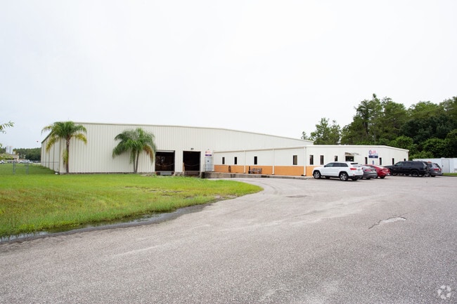
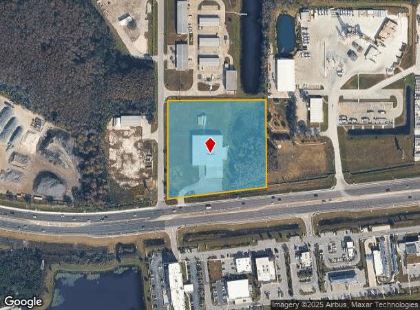
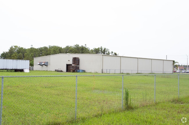
This Property Is For Sale
NEARBY LISTINGS FOR SALE OR LEASE
Property Detail
11805 State Road 54
Tampa-St. Petersburg-Clearwater, FL
Acreage
29-26-17-0000-00200-0030
COM AT AN IRON RAILROAD RAIL AT SE COR OF SECTION 29 TH ALG EAST BDY LINE OF SECTION 29 N0DEG 1937E 1132.12 FT TO NLY RIGHT-OF-WAY LINE OF STATE ROAD 54 AS IT IS NOW ESTABLISH -ED TH ALG NLY RIGHT-OF-WAY LINE OF SAID STATE ROAD NO 54 S81DEG1649W 759.
Winery
Pasco
AE
Florida
12101C0380F
3
2024
5.25 AC
2025
Pasco County
031701
Tampa/St Petersburg
30,300 SF
DEMOGRAPHICS near 11805 State Road 54
1 Mile
3 Mile
5 Mile
2024 Total Population
5,366
31,620
80,995
2029 Population
6,494
38,267
97,193
Pop Growth 2024-2029
+ 21.02%
+ 21.02%
+ 20.00%
Average Age
44
42
43
2024 Total Households
2,154
12,089
31,955
HH Growth 2024-2029
+ 20.89%
+ 21.02%
+ 19.93%
Median Household Inc
$103,931
$98,021
$84,689
Avg Household Size
2.50
2.60
2.50
2024 Avg HH Vehicles
2.00
2.00
2.00
Median Home Value
$359,338
$369,340
$334,535
Median Year Built
2010
2006
1999
Nearby Places
- Restaurants
- Banks
- Shops
- Fitness
- Groceries
PUBLIC TRANSPORTATION
AIRPORT
St Pete-Clearwater International
DRIVE
WALK
Distance
St Pete-Clearwater International
40 min
24.3 mi
Tampa International
DRIVE
WALK
Distance
Tampa International
37 min
25.2 mi
Freight Ports
Port of Tampa Bay
DRIVE
WALK
Distance
Port of Tampa Bay
49 min
30.7 mi
Nearby Properties
Address
Land Use
TOTAL SIZE
Lot Size
Zoning
Address
Land Use
TOTAL SIZE
Lot Size
Zoning
420,063 SF
42.64 AC
C2
Address
Land Use
TOTAL SIZE
Lot Size
Zoning
430,820 SF
19.14 AC
MPUD
Address
Land Use
TOTAL SIZE
Lot Size
Zoning
417,700 SF
28.91 AC
MPUD
Address
Land Use
TOTAL SIZE
Lot Size
Zoning
339,446 SF
16.29 AC
MPUD
Address
Land Use
TOTAL SIZE
Lot Size
Zoning
290,535 SF
14.91 AC
MPUD
Address
Land Use
TOTAL SIZE
Lot Size
Zoning
231,952 SF
19.51 AC
MPUD
Address
Land Use
TOTAL SIZE
Lot Size
Zoning
403,054 SF
117.69 AC
MPUD
Address
Land Use
TOTAL SIZE
Lot Size
Zoning
190,854 SF
14.90 AC
MPUD
Address
Land Use
TOTAL SIZE
Lot Size
Zoning
143,332 SF
17.40 AC
C2
Address
Land Use
TOTAL SIZE
Lot Size
Zoning
152,300 SF
2.82 AC
MF3
Address
Land Use
TOTAL SIZE
Lot Size
Zoning
1,017 AC
AR
Address
Land Use
TOTAL SIZE
Lot Size
Zoning
654.52 AC
AR
Address
Land Use
TOTAL SIZE
Lot Size
Zoning
59,874 SF
7.73 AC
MPUD
Address
Land Use
TOTAL SIZE
Lot Size
Zoning
83,958 SF
18.56 AC
MPUD
Address
Land Use
TOTAL SIZE
Lot Size
Zoning
80,957 SF
17.71 AC
MPUD
Address
Land Use
TOTAL SIZE
Lot Size
Zoning
70,248 SF
27.90 AC
R4
Address
Land Use
TOTAL SIZE
Lot Size
Zoning
100,984 SF
8.84 AC
MPUD
Address
Land Use
TOTAL SIZE
Lot Size
Zoning
53,744 SF
10.64 AC
MPUD
Address
Land Use
TOTAL SIZE
Lot Size
Zoning
61,760 SF
11.47 AC
MPUD
Address
Land Use
TOTAL SIZE
Lot Size
Zoning
85,547 SF
16.13 AC
MPUD
Address
Land Use
TOTAL SIZE
Lot Size
Zoning
109,894 SF
7.95 AC
C2
Address
Land Use
TOTAL SIZE
Lot Size
Zoning
106,039 SF
3.03 AC
MPUD
Address
Land Use
TOTAL SIZE
Lot Size
Zoning
74,679 SF
5.93 AC
MPUD
Address
Land Use
TOTAL SIZE
Lot Size
Zoning
85,600 SF
13.40 AC
C2
Address
Land Use
TOTAL SIZE
Lot Size
Zoning
89,308 SF
0.58 AC
C2
Address
Land Use
TOTAL SIZE
Lot Size
Zoning
75,844 SF
2.75 AC
C2
Address
Land Use
TOTAL SIZE
Lot Size
Zoning
83,628 SF
4.09 AC
MPUD
Address
Land Use
TOTAL SIZE
Lot Size
Zoning
106,266 SF
6.98 AC
MPUD
Address
Land Use
TOTAL SIZE
Lot Size
Zoning
20,433 SF
4.41 AC
MPUD
The World's #1 Commercial Real Estate Marketplace
Connect with us
© 2025 CoStar Group
The information above has been obtained from sources believed reliable. While we do not doubt its accuracy we have not verified it and make no guarantee, warranty or representation about it. It is your responsibility to independently confirm its accuracy and completeness. Any projections, opinions, assumptions, or estimates used are for example only and do not represent the current or future performance of the property. The value of this transaction to you depends on tax and other factors which should be evaluated by your tax, financial, and legal advisors. You and your advisors should conduct a careful, independent investigation of the property to determine to your satisfaction the suitability of the property for your needs.