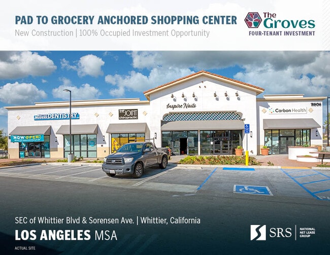
Property Record
11806 Whittier Blvd, Whittier, CA 90601
NEARBY LISTINGS FOR SALE OR LEASE
Property Detail
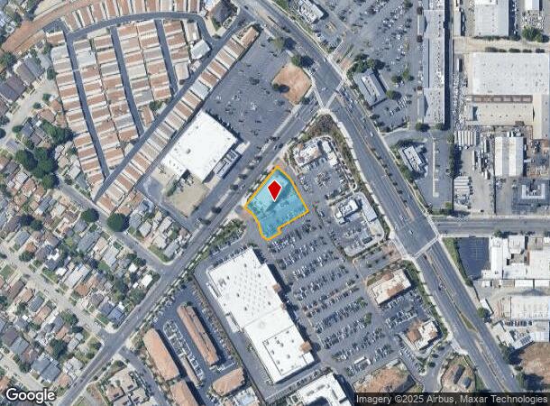
11806 Whittier Blvd
Los Angeles
Parcel Map No. 82776
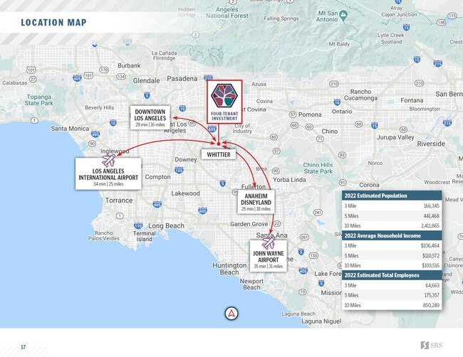
Los Angeles-Long Beach-Glendale, CA
PM 412-51-54 LOT 1
8170-039-030
Los Angeles
Regionalshoppingcenterormallwithanchorstore
California
2024
1
2025
0.71 AC
502100
Southeast Los Angeles
8,752 SF
DEMOGRAPHICS near 11806 Whittier Blvd
1 Mile
3 Mile
5 Mile
2024 Total Population
30,271
156,385
417,796
2029 Population
29,250
150,522
402,130
Pop Growth 2024-2029
(3.37%)
(3.75%)
(3.75%)
Average Age
39
40
40
2024 Total Households
10,165
46,538
123,297
HH Growth 2024-2029
(3.58%)
(4.00%)
(4.01%)
Median Household Inc
$63,833
$81,252
$85,178
Avg Household Size
2.90
3.20
3.30
2024 Avg HH Vehicles
2.00
2.00
2.00
Median Home Value
$676,950
$685,958
$698,415
Median Year Built
1953
1955
1957
Nearby Places
Map Layers
Map Styles
 Street
 Aerial
- Restaurants
- Banks
- Shops
- Fitness
- Groceries
PUBLIC TRANSPORTATION
COMMUTER RAIL
Montebello/Commerce (Riverside Line - Southern California Regional Rail Authority (Metrolink))
DRIVE
WALK
Distance
Montebello/Commerce (Riverside Line - Southern California Regional Rail Authority (Metrolink))
13 min
5.4 mi
Norwalk/Santa Fe Springs (91 Line - Southern California Regional Rail Authority (Metrolink), Orange County Line - Southern California Regional Rail Authority (Metrolink))
DRIVE
WALK
Distance
Norwalk/Santa Fe Springs (91 Line - Southern California Regional Rail Authority (Metrolink), Orange County Line - Southern California Regional Rail Authority (Metrolink))
11 min
5.5 mi
AIRPORT
Long Beach (Daugherty Field)
DRIVE
WALK
Distance
Long Beach (Daugherty Field)
27 min
17.6 mi
Los Angeles International
DRIVE
WALK
Distance
Los Angeles International
35 min
25.8 mi
Bob Hope
DRIVE
WALK
Distance
Bob Hope
42 min
30.0 mi
Freight Ports
Port of Long Beach
DRIVE
WALK
Distance
Port of Long Beach
33 min
23.3 mi
SALE & LEASE HISTORY
LISTING DATE
SALE/LEASE

Feb 28, 2023
For Sale
Nearby Properties
Address
Land Use
TOTAL SIZE
Lot Size
Zoning
Address
Land Use
TOTAL SIZE
Lot Size
Zoning
519,516 SF
25.37 AC
WHR3*
Address
Land Use
TOTAL SIZE
Lot Size
Zoning
1,100,900 SF
22.36 AC
SSM2*
Address
Land Use
TOTAL SIZE
Lot Size
Zoning
347,306 SF
14.37 AC
LCA25-CPD*
Address
Land Use
TOTAL SIZE
Lot Size
Zoning
613,248 SF
24.45 AC
LCA25-CPD*
Address
Land Use
TOTAL SIZE
Lot Size
Zoning
304,520 SF
14.18 AC
LCA25-CPD*
Address
Land Use
TOTAL SIZE
Lot Size
Zoning
260,528 SF
11.98 AC
LCA25-CPD*
Address
Land Use
TOTAL SIZE
Lot Size
Zoning
304,549 SF
7.13 AC
SSM2*
Address
Land Use
TOTAL SIZE
Lot Size
Zoning
234,324 SF
10.05 AC
SSM2*
Address
Land Use
TOTAL SIZE
Lot Size
Zoning
300,148 SF
13.01 AC
SSM2*
Address
Land Use
TOTAL SIZE
Lot Size
Zoning
173,100 SF
7.83 AC
PRIG*
Address
Land Use
TOTAL SIZE
Lot Size
Zoning
188,940 SF
9 AC
PR1G
Address
Land Use
TOTAL SIZE
Lot Size
Zoning
513,222 SF
13.35 AC
PR1G
Address
Land Use
TOTAL SIZE
Lot Size
Zoning
183,000 SF
7.76 AC
SSM2*
Address
Land Use
TOTAL SIZE
Lot Size
Zoning
657,978 SF
31.68 AC
SSM2*
Address
Land Use
TOTAL SIZE
Lot Size
Zoning
89,899 SF
SSM2*
Address
Land Use
TOTAL SIZE
Lot Size
Zoning
183,034 SF
19.57 AC
IDM11/2*
Address
Land Use
TOTAL SIZE
Lot Size
Zoning
73,661 SF
4.25 AC
SSR1
Address
Land Use
TOTAL SIZE
Lot Size
Zoning
74,018 SF
14.92 AC
WHM1*
Address
Land Use
TOTAL SIZE
Lot Size
Zoning
89,514 SF
21.28 AC
WHC2*
Address
Land Use
TOTAL SIZE
Lot Size
Zoning
425,816 SF
30.02 AC
SSM2*
Address
Land Use
TOTAL SIZE
Lot Size
Zoning
320,030 SF
8.81 AC
WHM2*
Address
Land Use
TOTAL SIZE
Lot Size
Zoning
184,230 SF
4.55 AC
SSM2*
Address
Land Use
TOTAL SIZE
Lot Size
Zoning
312,052 SF
6.78 AC
SSM2
Address
Land Use
TOTAL SIZE
Lot Size
Zoning
161,861 SF
17.50 AC
SSC4PD*
Address
Land Use
TOTAL SIZE
Lot Size
Zoning
313,965 SF
8.22 AC
PRCG*
Address
Land Use
TOTAL SIZE
Lot Size
Zoning
108,296 SF
8.81 AC
WHM2*
Address
Land Use
TOTAL SIZE
Lot Size
Zoning
216,952 SF
23.54 AC
WHR4*
Address
Land Use
TOTAL SIZE
Lot Size
Zoning
14,452 SF
13.52 AC
PRIG*
The World's #1 Commercial Real Estate Marketplace
Connect with us
© 2025 CoStar Group
The information above has been obtained from sources believed reliable. While we do not doubt its accuracy we have not verified it and make no guarantee, warranty or representation about it. It is your responsibility to independently confirm its accuracy and completeness. Any projections, opinions, assumptions, or estimates used are for example only and do not represent the current or future performance of the property. The value of this transaction to you depends on tax and other factors which should be evaluated by your tax, financial, and legal advisors. You and your advisors should conduct a careful, independent investigation of the property to determine to your satisfaction the suitability of the property for your needs.