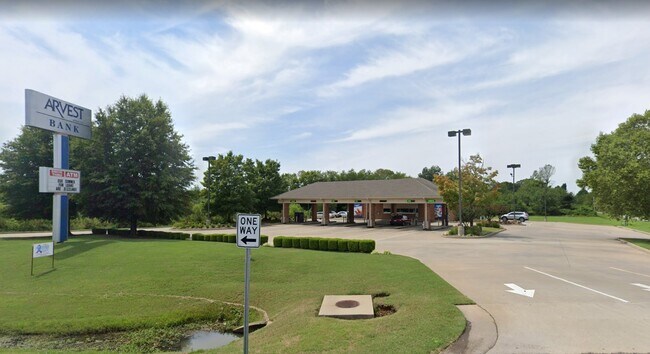
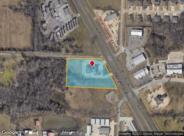
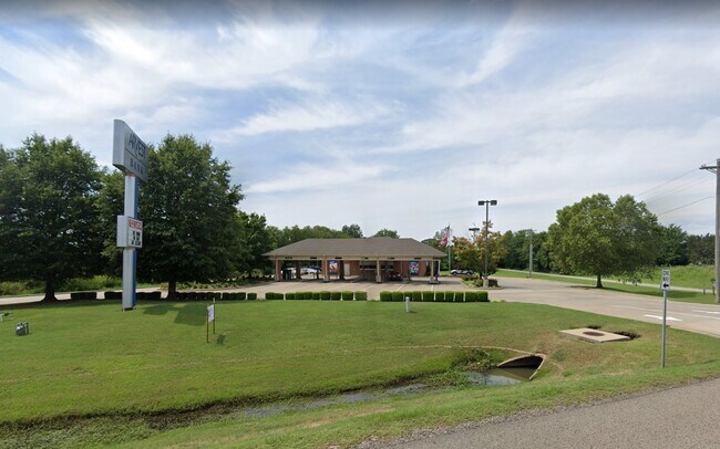
Property Record
11808 S Highway 71 Hwy S, Fort Smith, AR 72916
NEARBY LISTINGS FOR SALE OR LEASE
Property Detail
11808 S Highway 71 Hwy S
Fort Smith, AR-OK
Superior Federal Tracts-Gwd Sd
17747-0001-00000-00
TRACT 1
Medicalbuilding
Sebastian
X
Arkansas
05033C0475J
1
2025
3.50 AC
2025
Outlying Sebastian County
010301
Fort Smith
5,342 SF
DEMOGRAPHICS near 11808 S Highway 71 Hwy S
1 Mile
3 Mile
5 Mile
2024 Total Population
1,935
12,567
33,315
2029 Population
1,957
12,759
33,970
Pop Growth 2024-2029
+ 1.14%
+ 1.53%
+ 1.97%
Average Age
44
42
40
2024 Total Households
748
5,158
13,944
HH Growth 2024-2029
+ 1.34%
+ 1.59%
+ 2.02%
Median Household Inc
$139,558
$70,553
$59,584
Avg Household Size
2.60
2.40
2.30
2024 Avg HH Vehicles
3.00
2.00
2.00
Median Home Value
$286,236
$228,234
$184,161
Median Year Built
2003
1991
1989
Nearby Places
Map Layers
Map Styles
 Street
 Aerial
- Restaurants
- Banks
- Shops
- Fitness
- Groceries
PUBLIC TRANSPORTATION
AIRPORT
Fort Smith Regional
DRIVE
WALK
Distance
Fort Smith Regional
17 min
8.0 mi
Freight Ports
Tulsa Port of Inola
DRIVE
WALK
Distance
Tulsa Port of Inola
144 min
113.7 mi
SALE & LEASE HISTORY
LISTING DATE
SALE/LEASE

May 11, 2021
For Sale
Nearby Properties
Address
Land Use
TOTAL SIZE
Lot Size
Zoning
Address
Land Use
TOTAL SIZE
Lot Size
Zoning
124,455 SF
38.09 AC
Address
Land Use
TOTAL SIZE
Lot Size
Zoning
364,749 SF
32.41 AC
Address
Land Use
TOTAL SIZE
Lot Size
Zoning
212,590 SF
30.06 AC
Address
Land Use
TOTAL SIZE
Lot Size
Zoning
208,886 SF
212.42 AC
Address
Land Use
TOTAL SIZE
Lot Size
Zoning
342,092 SF
12.15 AC
Address
Land Use
TOTAL SIZE
Lot Size
Zoning
356,451 SF
44.13 AC
Address
Land Use
TOTAL SIZE
Lot Size
Zoning
89,157 SF
15.84 AC
Address
Land Use
TOTAL SIZE
Lot Size
Zoning
419,250 SF
22.86 AC
Address
Land Use
TOTAL SIZE
Lot Size
Zoning
105.25 AC
Address
Land Use
TOTAL SIZE
Lot Size
Zoning
61,881 SF
8.89 AC
Address
Land Use
TOTAL SIZE
Lot Size
Zoning
168,195 SF
33.51 AC
Address
Land Use
TOTAL SIZE
Lot Size
Zoning
111,684 SF
19.56 AC
Address
Land Use
TOTAL SIZE
Lot Size
Zoning
90,000 SF
7.93 AC
Address
Land Use
TOTAL SIZE
Lot Size
Zoning
145,467 SF
15.14 AC
Address
Land Use
TOTAL SIZE
Lot Size
Zoning
80,847 SF
38.07 AC
Address
Land Use
TOTAL SIZE
Lot Size
Zoning
105,410 SF
11.02 AC
Address
Land Use
TOTAL SIZE
Lot Size
Zoning
40,551 SF
5 AC
Address
Land Use
TOTAL SIZE
Lot Size
Zoning
30,311 SF
4.46 AC
Address
Land Use
TOTAL SIZE
Lot Size
Zoning
86,780 SF
20.16 AC
Address
Land Use
TOTAL SIZE
Lot Size
Zoning
42,988 SF
6.98 AC
Address
Land Use
TOTAL SIZE
Lot Size
Zoning
38,212 SF
5.73 AC
Address
Land Use
TOTAL SIZE
Lot Size
Zoning
23,548 SF
4.30 AC
Address
Land Use
TOTAL SIZE
Lot Size
Zoning
27,731 SF
5.18 AC
Address
Land Use
TOTAL SIZE
Lot Size
Zoning
56,421 SF
20 AC
Address
Land Use
TOTAL SIZE
Lot Size
Zoning
44,810 SF
7.70 AC
Address
Land Use
TOTAL SIZE
Lot Size
Zoning
33,570 SF
4.14 AC
Address
Land Use
TOTAL SIZE
Lot Size
Zoning
35,641 SF
0.96 AC
Address
Land Use
TOTAL SIZE
Lot Size
Zoning
86,522 SF
4.20 AC
Address
Land Use
TOTAL SIZE
Lot Size
Zoning
206,400 SF
11 AC
Address
Land Use
TOTAL SIZE
Lot Size
Zoning
13,759 SF
2.12 AC
The World's #1 Commercial Real Estate Marketplace
Connect with us
© 2026 CoStar Group
The information above has been obtained from sources believed reliable. While we do not doubt its accuracy we have not verified it and make no guarantee, warranty or representation about it. It is your responsibility to independently confirm its accuracy and completeness. Any projections, opinions, assumptions, or estimates used are for example only and do not represent the current or future performance of the property. The value of this transaction to you depends on tax and other factors which should be evaluated by your tax, financial, and legal advisors. You and your advisors should conduct a careful, independent investigation of the property to determine to your satisfaction the suitability of the property for your needs.