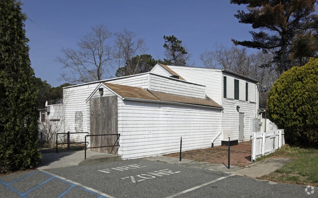
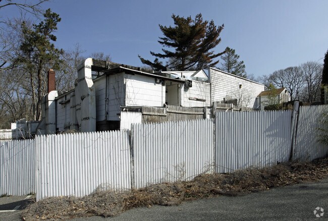
Property Record
1181 N Sea Rd, Southampton, NY 11968

NEARBY LISTINGS FOR SALE OR LEASE
Property Detail
1181 N Sea Rd
0900-097-00-01-00-024-001
99 INCL LOTS 24.1 & 24.2
Residentialacreage
Suffolk
X
New York
36103C0516H
25
0
9.80 AC
2024
Eastern Suffolk
190706
Long Island (New York)
3,877 SF
Nassau County-Suffolk County, NY
DEMOGRAPHICS near 1181 N Sea Rd
1 Mile
3 Mile
5 Mile
2024 Total Population
2,814
19,731
30,256
2029 Population
2,942
20,902
32,129
Pop Growth 2024-2029
+ 4.55%
+ 5.93%
+ 6.19%
Average Age
43
44
44
2024 Total Households
1,074
7,540
11,624
HH Growth 2024-2029
+ 4.38%
+ 5.93%
+ 6.17%
Median Household Inc
$94,400
$134,290
$141,025
Avg Household Size
2.50
2.50
2.50
2024 Avg HH Vehicles
2.00
2.00
2.00
Median Home Value
$876,992
$1,039,652
$1,046,070
Median Year Built
1977
1980
1982
Nearby Places
- Restaurants
- Banks
- Shops
- Fitness
- Groceries
PUBLIC TRANSPORTATION
COMMUTER RAIL
Southampton Station (Montauk Branch - Long Island Rail Road)
DRIVE
WALK
Distance
Southampton Station (Montauk Branch - Long Island Rail Road)
5 min
2.5 mi
Bridgehampton Station (Montauk Branch - Long Island Rail Road)
DRIVE
WALK
Distance
Bridgehampton Station (Montauk Branch - Long Island Rail Road)
15 min
6.8 mi
Freight Ports
Port of New Haven
DRIVE
WALK
Distance
Port of New Haven
172 min
76.8 mi
Nearby Properties
Address
Land Use
TOTAL SIZE
Lot Size
Zoning
Address
Land Use
TOTAL SIZE
Lot Size
Zoning
2,164.20 AC
H2O
Address
Land Use
TOTAL SIZE
Lot Size
Zoning
182,225 SF
6.16 AC
VILLA
Address
Land Use
TOTAL SIZE
Lot Size
Zoning
8.70 AC
VILLA
Address
Land Use
TOTAL SIZE
Lot Size
Zoning
42 AC
VILLA
Address
Land Use
TOTAL SIZE
Lot Size
Zoning
127,866 SF
5.70 AC
VILLA
Address
Land Use
TOTAL SIZE
Lot Size
Zoning
25,018 SF
9.11 AC
VILLA
Address
Land Use
TOTAL SIZE
Lot Size
Zoning
37,222 SF
13.77 AC
CR60
Address
Land Use
TOTAL SIZE
Lot Size
Zoning
12,145 SF
2.60 AC
CR60
Address
Land Use
TOTAL SIZE
Lot Size
Zoning
65,835 SF
7.20 AC
VILLA
Address
Land Use
TOTAL SIZE
Lot Size
Zoning
4,670 SF
238.30 AC
SMUPD
Address
Land Use
TOTAL SIZE
Lot Size
Zoning
9,385 SF
5.42 AC
VILLA
Address
Land Use
TOTAL SIZE
Lot Size
Zoning
73,470 SF
122.50 AC
OSC
Address
Land Use
TOTAL SIZE
Lot Size
Zoning
377 AC
H2O
Address
Land Use
TOTAL SIZE
Lot Size
Zoning
23,316 SF
202.05 AC
R120
Address
Land Use
TOTAL SIZE
Lot Size
Zoning
13,332 SF
4.40 AC
VILLA
Address
Land Use
TOTAL SIZE
Lot Size
Zoning
12,174 SF
2.60 AC
VILLA
Address
Land Use
TOTAL SIZE
Lot Size
Zoning
19,914 SF
4.31 AC
VILLA
Address
Land Use
TOTAL SIZE
Lot Size
Zoning
5,124 SF
1.90 AC
VILLA
Address
Land Use
TOTAL SIZE
Lot Size
Zoning
45.91 AC
CR120
Address
Land Use
TOTAL SIZE
Lot Size
Zoning
45 AC
CR120
Address
Land Use
TOTAL SIZE
Lot Size
Zoning
276.90 AC
H2O
Address
Land Use
TOTAL SIZE
Lot Size
Zoning
11 AC
VILLA
Address
Land Use
TOTAL SIZE
Lot Size
Zoning
123,212 SF
185.30 AC
R120
Address
Land Use
TOTAL SIZE
Lot Size
Zoning
8.51 AC
LI40
Address
Land Use
TOTAL SIZE
Lot Size
Zoning
1,800 SF
43.50 AC
R20
Address
Land Use
TOTAL SIZE
Lot Size
Zoning
3.57 AC
VILLA
Address
Land Use
TOTAL SIZE
Lot Size
Zoning
11,058 SF
5.65 AC
CR80
Address
Land Use
TOTAL SIZE
Lot Size
Zoning
34,248 SF
3.70 AC
VILLA
Address
Land Use
TOTAL SIZE
Lot Size
Zoning
2.90 AC
VILLA
Address
Land Use
TOTAL SIZE
Lot Size
Zoning
7,725 SF
5.80 AC
R60
The World's #1 Commercial Real Estate Marketplace
Connect with us
© 2025 CoStar Group
The information above has been obtained from sources believed reliable. While we do not doubt its accuracy we have not verified it and make no guarantee, warranty or representation about it. It is your responsibility to independently confirm its accuracy and completeness. Any projections, opinions, assumptions, or estimates used are for example only and do not represent the current or future performance of the property. The value of this transaction to you depends on tax and other factors which should be evaluated by your tax, financial, and legal advisors. You and your advisors should conduct a careful, independent investigation of the property to determine to your satisfaction the suitability of the property for your needs.