Property Record
11815 E Apache St, Tulsa, OK 74116
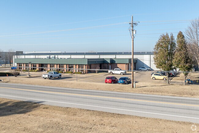
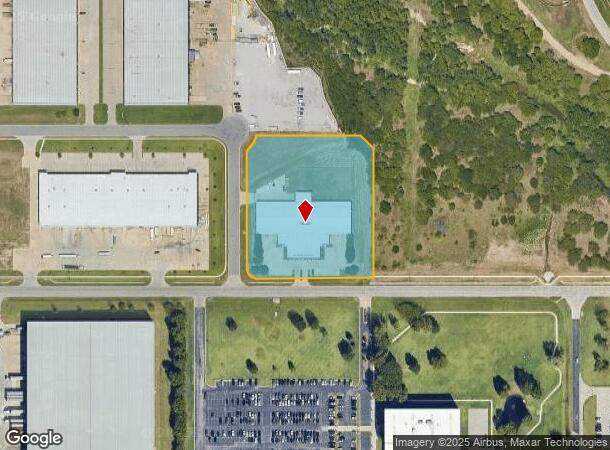

Property Detail
11815 E Apache St
Tulsa, OK
Airpark Distribution Center
01310-04-20-53510
LT 6 BLK 1
Warehouse
Tulsa
X
Oklahoma
40143C0253L
6
2025
4.09 AC
2025
Northeast Tulsa
005900
Tulsa
38,950 SF
NEARBY LISTINGS FOR SALE OR LEASE
DEMOGRAPHICS near 11815 E Apache St
1 mile
3 mile
5 mile
2024 Total Population
5
13,060
77,140
2029 Population
6
13,602
79,983
Pop Growth 2024-2029
+ 20.00%
+ 4.15%
+ 3.69%
Average Age
12
35
36
2024 Total Households
2
4,607
28,532
HH Growth 2024-2029
0.00%
+ 4.25%
+ 3.76%
Median Household Inc
$5,000
$46,429
$43,634
Avg Household Size
1.00
2.70
2.60
2024 Avg HH Vehicles
1.00
2.00
2.00
Median Home Value
$0
$83,263
$99,134
Median Year Built
0
1964
1968
Nearby Places
Map Layers
Map Styles
 Street
 Aerial
Transit
 Traffic
 Biking
Places
Listings with unknown addresses are not visible on the map
- Restaurants
- Banks
- Shops
- Fitness
- Groceries
PUBLIC TRANSPORTATION
AIRPORT
Tulsa International
Drive
Walk
Distance
Tulsa International
11 min
6.1 mi
SALE & LEASE HISTORY
LISTING DATE
SALE/LEASE

Sep 25, 2016
For Lease
Jul 31, 2024
For Lease
Nearby Properties
Address
Land Use
TOTAL SIZE
Lot Size
Zoning
Address
Land Use
TOTAL SIZE
Lot Size
Zoning
609,418 SF
177.77 AC
IM
Address
Land Use
TOTAL SIZE
Lot Size
Zoning
349,823 SF
203.39 AC
IL
Address
Land Use
TOTAL SIZE
Lot Size
Zoning
2,689,602 SF
81.80 AC
IH
Address
Land Use
TOTAL SIZE
Lot Size
Zoning
1 SF
207.77 AC
IM
Address
Land Use
TOTAL SIZE
Lot Size
Zoning
228.59 AC
IL
Address
Land Use
TOTAL SIZE
Lot Size
Zoning
725,973 SF
122.30 AC
IM
Address
Land Use
TOTAL SIZE
Lot Size
Zoning
112,556 SF
11.07 AC
CH
Address
Land Use
TOTAL SIZE
Lot Size
Zoning
110.77 AC
IL
Address
Land Use
TOTAL SIZE
Lot Size
Zoning
11,184 SF
638.56 AC
Address
Land Use
TOTAL SIZE
Lot Size
Zoning
103,248 SF
8.87 AC
IL
Address
Land Use
TOTAL SIZE
Lot Size
Zoning
97.68 AC
CH
Address
Land Use
TOTAL SIZE
Lot Size
Zoning
106,270 SF
9.47 AC
RM0
Address
Land Use
TOTAL SIZE
Lot Size
Zoning
124,648 SF
21.23 AC
IL
Address
Land Use
TOTAL SIZE
Lot Size
Zoning
139.39 AC
IM
Address
Land Use
TOTAL SIZE
Lot Size
Zoning
275,768 SF
49.62 AC
IM
Address
Land Use
TOTAL SIZE
Lot Size
Zoning
19,708 SF
21.04 AC
IL
Address
Land Use
TOTAL SIZE
Lot Size
Zoning
187,351 SF
218.26 AC
IL
Address
Land Use
TOTAL SIZE
Lot Size
Zoning
185,649 SF
56.23 AC
IL
Address
Land Use
TOTAL SIZE
Lot Size
Zoning
55,425 SF
2.96 AC
IL
Address
Land Use
TOTAL SIZE
Lot Size
Zoning
56,531 SF
7.79 AC
RS3
Address
Land Use
TOTAL SIZE
Lot Size
Zoning
147,683 SF
9.19 AC
IL
Address
Land Use
TOTAL SIZE
Lot Size
Zoning
53.24 AC
IM
Address
Land Use
TOTAL SIZE
Lot Size
Zoning
673,050 SF
52.77 AC
IM
Address
Land Use
TOTAL SIZE
Lot Size
Zoning
75.35 AC
AG
Address
Land Use
TOTAL SIZE
Lot Size
Zoning
40,202 SF
2.93 AC
RM0
Address
Land Use
TOTAL SIZE
Lot Size
Zoning
609,418 SF
49.83 AC
IM
Address
Land Use
TOTAL SIZE
Lot Size
Zoning
39.06 AC
IL
Address
Land Use
TOTAL SIZE
Lot Size
Zoning
371,153 SF
22.82 AC
IL
The World's #1 Commercial Real Estate Marketplace
Connect with us
© 2026 CoStar Group
The information above has been obtained from sources believed reliable. While we do not doubt its accuracy we have not verified it and make no guarantee, warranty or representation about it. It is your responsibility to independently confirm its accuracy and completeness. Any projections, opinions, assumptions, or estimates used are for example only and do not represent the current or future performance of the property. The value of this transaction to you depends on tax and other factors which should be evaluated by your tax, financial, and legal advisors. You and your advisors should conduct a careful, independent investigation of the property to determine to your satisfaction the suitability of the property for your needs.