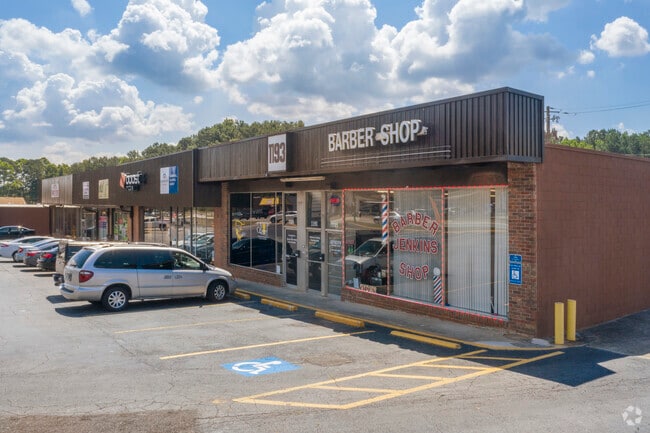
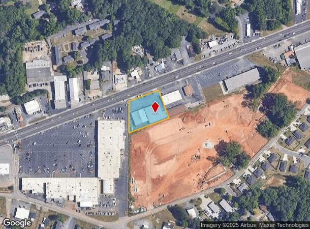
Property Record
1195 Veterans Memorial Hwy Sw, Mableton, GA 30126
Current Lease Availabilities
General Retail LEASE
$12.50 SF/YR
1,440 - 9,520 SF
NEARBY LISTINGS FOR SALE OR LEASE
Property Detail
1195 Veterans Memorial Hwy Sw
19-1297-0-017-0
Bankhead Sub Sec 1
Regionalshoppingcenterormallwithanchorstore
Cobb
X
Georgia
13067C0204G
4-8
2025
1.24 AC
2025
Powder Spring/Austell
031308
Atlanta
17,200 SF
Atlanta-Sandy Springs-Roswell, GA
DEMOGRAPHICS near 1195 Veterans Memorial Hwy Sw
1 Mile
3 Mile
5 Mile
2024 Total Population
6,348
63,722
147,532
2029 Population
6,496
64,906
150,455
Pop Growth 2024-2029
+ 2.33%
+ 1.86%
+ 1.98%
Average Age
37
38
38
2024 Total Households
2,229
23,884
55,286
HH Growth 2024-2029
+ 2.33%
+ 1.83%
+ 1.97%
Median Household Inc
$67,421
$67,008
$71,549
Avg Household Size
2.80
2.60
2.60
2024 Avg HH Vehicles
2.00
2.00
2.00
Median Home Value
$230,113
$239,729
$271,187
Median Year Built
1972
1983
1988
Nearby Places
- Restaurants
- Banks
- Shops
- Fitness
- Groceries
PUBLIC TRANSPORTATION
AIRPORT
Hartsfield - Jackson Atlanta International
DRIVE
WALK
Distance
Hartsfield - Jackson Atlanta International
35 min
23.7 mi
Freight Ports
Georgia Ports - Savannah
DRIVE
WALK
Distance
Georgia Ports - Savannah
297 min
261.0 mi
Nearby Properties
Address
Land Use
TOTAL SIZE
Lot Size
Zoning
Address
Land Use
TOTAL SIZE
Lot Size
Zoning
494,972 SF
25.60 AC
CF
Address
Land Use
TOTAL SIZE
Lot Size
Zoning
403,898 SF
37.53 AC
RM-12
Address
Land Use
TOTAL SIZE
Lot Size
Zoning
840,110 SF
53.36 AC
PUD
Address
Land Use
TOTAL SIZE
Lot Size
Zoning
789,717 SF
68.55 AC
LI
Address
Land Use
TOTAL SIZE
Lot Size
Zoning
272,170 SF
26.40 AC
RM-12
Address
Land Use
TOTAL SIZE
Lot Size
Zoning
307,169 SF
30.13 AC
LI
Address
Land Use
TOTAL SIZE
Lot Size
Zoning
285,933 SF
46.22 AC
R-MF
Address
Land Use
TOTAL SIZE
Lot Size
Zoning
290,784 SF
21.09 AC
RM-12
Address
Land Use
TOTAL SIZE
Lot Size
Zoning
238,984 SF
17.51 AC
RM-12
Address
Land Use
TOTAL SIZE
Lot Size
Zoning
240,612 SF
23.22 AC
R-6
Address
Land Use
TOTAL SIZE
Lot Size
Zoning
380,000 SF
33.97 AC
IL
Address
Land Use
TOTAL SIZE
Lot Size
Zoning
151,436 SF
11.42 AC
RM-12
Address
Land Use
TOTAL SIZE
Lot Size
Zoning
280,670 SF
23 AC
PVC
Address
Land Use
TOTAL SIZE
Lot Size
Zoning
118,069 SF
0.38 AC
OI
Address
Land Use
TOTAL SIZE
Lot Size
Zoning
312,093 SF
19.79 AC
PUD
Address
Land Use
TOTAL SIZE
Lot Size
Zoning
15.98 AC
LI
Address
Land Use
TOTAL SIZE
Lot Size
Zoning
3.46 AC
RM-12
Address
Land Use
TOTAL SIZE
Lot Size
Zoning
312,240 SF
24.58 AC
PUD
Address
Land Use
TOTAL SIZE
Lot Size
Zoning
111,246 SF
11.28 AC
RM-12
Address
Land Use
TOTAL SIZE
Lot Size
Zoning
122,697 SF
13.02 AC
PUD
Address
Land Use
TOTAL SIZE
Lot Size
Zoning
121,625 SF
10.40 AC
RM-12
Address
Land Use
TOTAL SIZE
Lot Size
Zoning
198,052 SF
24.52 AC
NRC/CRC
Address
Land Use
TOTAL SIZE
Lot Size
Zoning
109,072 SF
15.23 AC
NRC
Address
Land Use
TOTAL SIZE
Lot Size
Zoning
119,424 SF
11.32 AC
RM-12
Address
Land Use
TOTAL SIZE
Lot Size
Zoning
83,314 SF
15.74 AC
NRC
Address
Land Use
TOTAL SIZE
Lot Size
Zoning
98,574 SF
10.27 AC
CRC
Address
Land Use
TOTAL SIZE
Lot Size
Zoning
113,244 SF
7.95 AC
RM-12
Address
Land Use
TOTAL SIZE
Lot Size
Zoning
115,380 SF
10.12 AC
RM-12
Address
Land Use
TOTAL SIZE
Lot Size
Zoning
204,017 SF
25.59 AC
CG
Address
Land Use
TOTAL SIZE
Lot Size
Zoning
182,092 SF
9.70 AC
IL
The World's #1 Commercial Real Estate Marketplace
Connect with us
© 2025 CoStar Group
The information above has been obtained from sources believed reliable. While we do not doubt its accuracy we have not verified it and make no guarantee, warranty or representation about it. It is your responsibility to independently confirm its accuracy and completeness. Any projections, opinions, assumptions, or estimates used are for example only and do not represent the current or future performance of the property. The value of this transaction to you depends on tax and other factors which should be evaluated by your tax, financial, and legal advisors. You and your advisors should conduct a careful, independent investigation of the property to determine to your satisfaction the suitability of the property for your needs.