Property Record
11834 Bryant St, Yucaipa, CA 92399


NEARBY LISTINGS FOR SALE OR LEASE
-
-
View all Yucaipa listings for sale on LoopNet.com
Property Detail
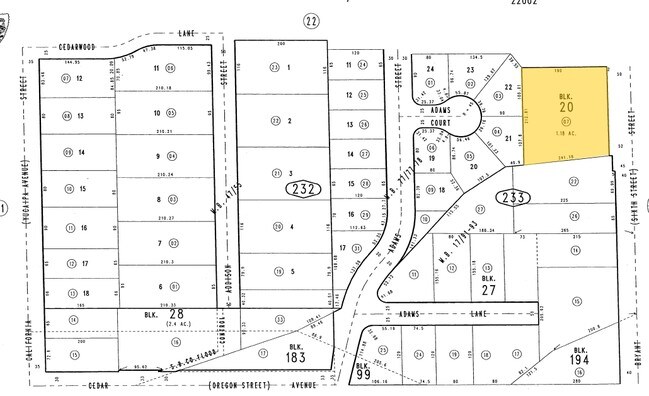
11834 Bryant St
0303-233-07
Revised Map Of Yucaipa City
Medicalbuilding
REVISED MAP OF YUCAIPA CITY PTN BLK 20 COM AT A PT ON E LI SD BLK IN CEN LI BRYANT ST S 60 FT FROM NE COR SD BLK TH PARALLEL WITH N LI SD BLK W 240 FT TH S PARALLEL WITH CEN LI BRYANT ST 212.72 FT TO SLY LI BLK 20 TH ALG SD LI N 84 DEG 20 MIN E 241.1
X
San Bernardino
06071C8745H
California
2024
1.18 AC
2025
Redlands/Loma Linda
008800
Inland Empire (California)
5,434 SF
Riverside-San Bernardino-Ontario, CA
DEMOGRAPHICS near 11834 Bryant St
1 Mile
3 Mile
5 Mile
2024 Total Population
12,209
53,958
70,139
2029 Population
12,435
55,183
72,004
Pop Growth 2024-2029
+ 1.85%
+ 2.27%
+ 2.66%
Average Age
39
40
40
2024 Total Households
4,401
19,436
25,076
HH Growth 2024-2029
+ 1.86%
+ 2.29%
+ 2.61%
Median Household Inc
$83,923
$78,491
$82,270
Avg Household Size
2.70
2.70
2.80
2024 Avg HH Vehicles
2.00
2.00
2.00
Median Home Value
$434,519
$440,801
$454,459
Median Year Built
1967
1976
1978
Nearby Places
Map Layers
Map Styles
 Street
 Aerial
- Restaurants
- Banks
- Shops
- Fitness
- Groceries
PUBLIC TRANSPORTATION
COMMUTER RAIL
Redlands - University Metrolink Station (Metrolink San Bernardino Line - Metrolink Trains)
DRIVE
WALK
Distance
Redlands - University Metrolink Station (Metrolink San Bernardino Line - Metrolink Trains)
15 min
9.2 mi
Freight Ports
Port of Long Beach
DRIVE
WALK
Distance
Port of Long Beach
103 min
80.2 mi
Nearby Properties
Address
Land Use
TOTAL SIZE
Lot Size
Zoning
Address
Land Use
TOTAL SIZE
Lot Size
Zoning
369,838 SF
19.32 AC
Address
Land Use
TOTAL SIZE
Lot Size
Zoning
102,506 SF
4.47 AC
Address
Land Use
TOTAL SIZE
Lot Size
Zoning
82,694 SF
3.41 AC
Address
Land Use
TOTAL SIZE
Lot Size
Zoning
5.47 AC
Address
Land Use
TOTAL SIZE
Lot Size
Zoning
79,299 SF
5.04 AC
Address
Land Use
TOTAL SIZE
Lot Size
Zoning
67,686 SF
4.16 AC
Address
Land Use
TOTAL SIZE
Lot Size
Zoning
56,491 SF
7.50 AC
Address
Land Use
TOTAL SIZE
Lot Size
Zoning
56,491 SF
3.39 AC
Address
Land Use
TOTAL SIZE
Lot Size
Zoning
22,308 SF
1.87 AC
Address
Land Use
TOTAL SIZE
Lot Size
Zoning
24,510 SF
6.88 AC
Address
Land Use
TOTAL SIZE
Lot Size
Zoning
29,387 SF
3.21 AC
Address
Land Use
TOTAL SIZE
Lot Size
Zoning
27,627 SF
5.07 AC
Address
Land Use
TOTAL SIZE
Lot Size
Zoning
42,634 SF
1.91 AC
Address
Land Use
TOTAL SIZE
Lot Size
Zoning
111,182 SF
3.11 AC
Address
Land Use
TOTAL SIZE
Lot Size
Zoning
15,980 SF
1.56 AC
Address
Land Use
TOTAL SIZE
Lot Size
Zoning
44,046 SF
3.77 AC
Address
Land Use
TOTAL SIZE
Lot Size
Zoning
33,000 SF
2.96 AC
Address
Land Use
TOTAL SIZE
Lot Size
Zoning
78,309 SF
7.09 AC
Address
Land Use
TOTAL SIZE
Lot Size
Zoning
29,996 SF
1.86 AC
Address
Land Use
TOTAL SIZE
Lot Size
Zoning
9.71 AC
Address
Land Use
TOTAL SIZE
Lot Size
Zoning
1,970 SF
6.27 AC
Address
Land Use
TOTAL SIZE
Lot Size
Zoning
41,040 SF
4.70 AC
Address
Land Use
TOTAL SIZE
Lot Size
Zoning
23,227 SF
1.81 AC
Address
Land Use
TOTAL SIZE
Lot Size
Zoning
45,862 SF
4.51 AC
Address
Land Use
TOTAL SIZE
Lot Size
Zoning
44,864 SF
5.34 AC
Address
Land Use
TOTAL SIZE
Lot Size
Zoning
17,326 SF
2.24 AC
Address
Land Use
TOTAL SIZE
Lot Size
Zoning
50,936 SF
6.50 AC
936
Address
Land Use
TOTAL SIZE
Lot Size
Zoning
35,688 SF
3.03 AC
Address
Land Use
TOTAL SIZE
Lot Size
Zoning
55,073 SF
4.43 AC
Address
Land Use
TOTAL SIZE
Lot Size
Zoning
18,586 SF
1.63 AC
The World's #1 Commercial Real Estate Marketplace
Connect with us
© 2025 CoStar Group
The information above has been obtained from sources believed reliable. While we do not doubt its accuracy we have not verified it and make no guarantee, warranty or representation about it. It is your responsibility to independently confirm its accuracy and completeness. Any projections, opinions, assumptions, or estimates used are for example only and do not represent the current or future performance of the property. The value of this transaction to you depends on tax and other factors which should be evaluated by your tax, financial, and legal advisors. You and your advisors should conduct a careful, independent investigation of the property to determine to your satisfaction the suitability of the property for your needs.