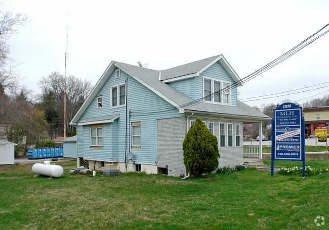
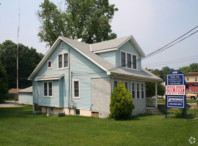
Property Record
11836 Belair Rd, Kingsville, MD 21087

NEARBY LISTINGS FOR SALE OR LEASE
Property Detail
11836 Belair Rd
Baltimore-Columbia-Towson, MD
Cedar Lane Farms 02 Ph 03
11-1108001675
.347 AC
Commercialnec
Baltimore
X
Maryland
2400100285G
51
2024
0.35 AC
2025
Baltimore County East
411101
Baltimore
1,302 SF
DEMOGRAPHICS near 11836 Belair Rd
1 Mile
3 Mile
5 Mile
2024 Total Population
1,559
14,980
67,276
2029 Population
1,533
14,989
67,335
Pop Growth 2024-2029
(1.67%)
+ 0.06%
+ 0.09%
Average Age
47
45
43
2024 Total Households
584
5,557
25,052
HH Growth 2024-2029
(1.71%)
(0.04%)
+ 0.06%
Median Household Inc
$117,261
$116,824
$110,313
Avg Household Size
2.70
2.60
2.60
2024 Avg HH Vehicles
2.00
2.00
2.00
Median Home Value
$475,640
$422,975
$363,446
Median Year Built
1968
1978
1983
Nearby Places
Map Layers
Map Styles
 Street
 Aerial
- Restaurants
- Banks
- Shops
- Fitness
- Groceries
PUBLIC TRANSPORTATION
COMMUTER RAIL
Edgewood (Penn Line - Maryland Area Regional Commuter Trains (The MARC))
DRIVE
WALK
Distance
Edgewood (Penn Line - Maryland Area Regional Commuter Trains (The MARC))
19 min
8.9 mi
AIRPORT
Baltimore/Washington International Thurgood Marshall
DRIVE
WALK
Distance
Baltimore/Washington International Thurgood Marshall
45 min
28.8 mi
Freight Ports
Port of Baltimore
DRIVE
WALK
Distance
Port of Baltimore
35 min
22.2 mi
Nearby Properties
Address
Land Use
TOTAL SIZE
Lot Size
Zoning
Address
Land Use
TOTAL SIZE
Lot Size
Zoning
35,170 SF
5.50 AC
BM
Address
Land Use
TOTAL SIZE
Lot Size
Zoning
16,129 SF
58.25 AC
AG
Address
Land Use
TOTAL SIZE
Lot Size
Zoning
25,196 SF
4.20 AC
BM
Address
Land Use
TOTAL SIZE
Lot Size
Zoning
53,500 SF
13 AC
RC5
Address
Land Use
TOTAL SIZE
Lot Size
Zoning
25,704 SF
6.77 AC
Address
Land Use
TOTAL SIZE
Lot Size
Zoning
40,035 SF
13.54 AC
Address
Land Use
TOTAL SIZE
Lot Size
Zoning
13,092 SF
1.65 AC
BL-BR
Address
Land Use
TOTAL SIZE
Lot Size
Zoning
14,892 SF
2.20 AC
BLR
Address
Land Use
TOTAL SIZE
Lot Size
Zoning
40,148 SF
16.38 AC
Address
Land Use
TOTAL SIZE
Lot Size
Zoning
13,090 SF
1.71 AC
Address
Land Use
TOTAL SIZE
Lot Size
Zoning
8,274 SF
262.80 AC
AG
Address
Land Use
TOTAL SIZE
Lot Size
Zoning
18,030 SF
3.86 AC
Address
Land Use
TOTAL SIZE
Lot Size
Zoning
33,298 SF
4.75 AC
RC2
Address
Land Use
TOTAL SIZE
Lot Size
Zoning
38,751 SF
10.51 AC
Address
Land Use
TOTAL SIZE
Lot Size
Zoning
20,849 SF
7.46 AC
Address
Land Use
TOTAL SIZE
Lot Size
Zoning
19,594 SF
20.71 AC
Address
Land Use
TOTAL SIZE
Lot Size
Zoning
45,453 SF
7.30 AC
BR
Address
Land Use
TOTAL SIZE
Lot Size
Zoning
5,676 SF
1.54 AC
Address
Land Use
TOTAL SIZE
Lot Size
Zoning
2.74 AC
BM
Address
Land Use
TOTAL SIZE
Lot Size
Zoning
1,250 SF
2.27 AC
B3 AG
Address
Land Use
TOTAL SIZE
Lot Size
Zoning
14,408 SF
7.35 AC
DR1
Address
Land Use
TOTAL SIZE
Lot Size
Zoning
4,752 SF
2.62 AC
B3
Address
Land Use
TOTAL SIZE
Lot Size
Zoning
9,543 SF
1.14 AC
BL
Address
Land Use
TOTAL SIZE
Lot Size
Zoning
2,996 SF
17.02 AC
AG
Address
Land Use
TOTAL SIZE
Lot Size
Zoning
2,592 SF
2.50 AC
BR
Address
Land Use
TOTAL SIZE
Lot Size
Zoning
1.56 AC
BM
Address
Land Use
TOTAL SIZE
Lot Size
Zoning
9,512 SF
2 AC
Address
Land Use
TOTAL SIZE
Lot Size
Zoning
12,426 SF
3.45 AC
BL
Address
Land Use
TOTAL SIZE
Lot Size
Zoning
9,352 SF
2.12 AC
RC2
Address
Land Use
TOTAL SIZE
Lot Size
Zoning
The World's #1 Commercial Real Estate Marketplace
Connect with us
© 2025 CoStar Group
The information above has been obtained from sources believed reliable. While we do not doubt its accuracy we have not verified it and make no guarantee, warranty or representation about it. It is your responsibility to independently confirm its accuracy and completeness. Any projections, opinions, assumptions, or estimates used are for example only and do not represent the current or future performance of the property. The value of this transaction to you depends on tax and other factors which should be evaluated by your tax, financial, and legal advisors. You and your advisors should conduct a careful, independent investigation of the property to determine to your satisfaction the suitability of the property for your needs.