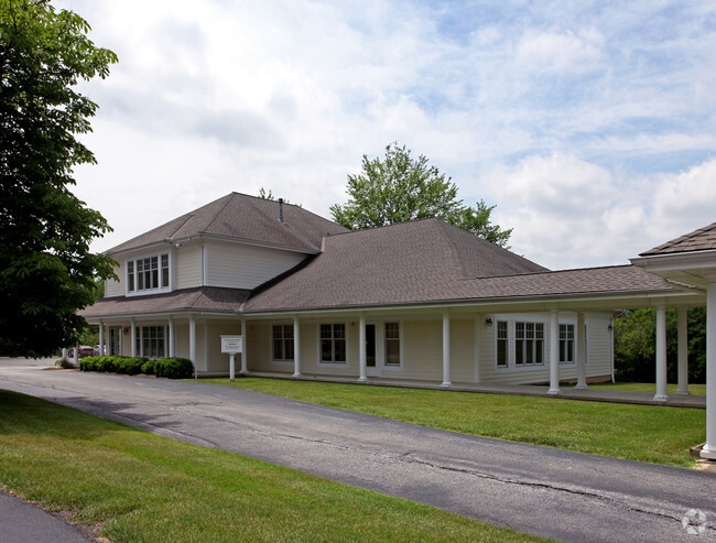
Property Record
1184 Bell Rd, Chagrin Falls, OH 44022


Save to a Folder
{{folder.Name}}
{{folder.ListingIds.length}} Properties
{{folder.ListingIds.length}} Property
Create a New Folder
Property Detail
1184 Bell Rd
29-041090
LOT 9 TR 3
Medicalbuilding
Geauga
B2
Ohio
B and X Area of moderate flood hazard, usually the area between the limits of the 100-year and 500-year floods.
9
2025
1 AC
2025
Geauga County
311600
Cleveland
7,840 SF
Cleveland-Elyria, OH
NEARBY LISTINGS FOR SALE OR LEASE
DEMOGRAPHICS near 1184 Bell Rd
1 mile
3 mile
5 mile
2025 Total Population
2,914
18,129
35,363
2030 Population
2,882
18,089
35,262
Pop Growth 2025-2030
(1.10%)
(0.22%)
(0.29%)
Average Age
44
46
46
2025 Total Households
1,004
7,002
13,527
HH Growth 2025-2030
(1.20%)
(0.19%)
(0.32%)
Median Household Inc
$159,524
$120,220
$130,053
Avg Household Size
2.70
2.50
2.50
2025 Avg HH Vehicles
2.00
2.00
2.00
Median Home Value
$437,186
$424,556
$428,260
Median Year Built
1977
1970
1972
Nearby Places
Map Layers
Map Styles
 Street
 Aerial
Layers
 Traffic
 Biking
Places
Listings with unknown addresses are not visible on the map
- Restaurants
- Banks
- Shops
- Fitness
- Groceries
PUBLIC TRANSPORTATION
AIRPORT
Cleveland-Hopkins International
Drive
Walk
Distance
Cleveland-Hopkins International
47 min
33.0 mi
Nearby Properties
Address
Land Use
TOTAL SIZE
Lot Size
Zoning
Address
Land Use
TOTAL SIZE
Lot Size
Zoning
7,531 SF
85.32 AC
R3A
Address
Land Use
TOTAL SIZE
Lot Size
Zoning
225,206 SF
55.30 AC
PI
Address
Land Use
TOTAL SIZE
Lot Size
Zoning
18,614 SF
45.79 AC
R3A
Address
Land Use
TOTAL SIZE
Lot Size
Zoning
2,620 SF
15.81 AC
R5A
Address
Land Use
TOTAL SIZE
Lot Size
Zoning
120,010 SF
11.92 AC
CB
Address
Land Use
TOTAL SIZE
Lot Size
Zoning
93,610 SF
4.45 AC
RL
Address
Land Use
TOTAL SIZE
Lot Size
Zoning
77,296 SF
3.33 AC
RB
Address
Land Use
TOTAL SIZE
Lot Size
Zoning
67,861 SF
24.84 AC
R1A
Address
Land Use
TOTAL SIZE
Lot Size
Zoning
30,295 SF
7.12 AC
R5A
Address
Land Use
TOTAL SIZE
Lot Size
Zoning
86,896 SF
1.55 AC
PI
Address
Land Use
TOTAL SIZE
Lot Size
Zoning
58,075 SF
10.63 AC
PI
Address
Land Use
TOTAL SIZE
Lot Size
Zoning
20,192 SF
363.31 AC
PPD
Address
Land Use
TOTAL SIZE
Lot Size
Zoning
38,845 SF
8.84 AC
B3
Address
Land Use
TOTAL SIZE
Lot Size
Zoning
125,740 SF
33.72 AC
RL
Address
Land Use
TOTAL SIZE
Lot Size
Zoning
36,827 SF
6.54 AC
R5A
Address
Land Use
TOTAL SIZE
Lot Size
Zoning
43,221 SF
14.17 AC
LIR
Address
Land Use
TOTAL SIZE
Lot Size
Zoning
34,354 SF
1.04 AC
PI
Address
Land Use
TOTAL SIZE
Lot Size
Zoning
51,653 SF
5.76 AC
CB
Address
Land Use
TOTAL SIZE
Lot Size
Zoning
56,518 SF
5.86 AC
RMF-10
Address
Land Use
TOTAL SIZE
Lot Size
Zoning
73.85 AC
C
Address
Land Use
TOTAL SIZE
Lot Size
Zoning
21,960 SF
0.42 AC
CS
Address
Land Use
TOTAL SIZE
Lot Size
Zoning
68,022 SF
3 AC
R3A
Address
Land Use
TOTAL SIZE
Lot Size
Zoning
15,098 SF
1.32 AC
PI
Address
Land Use
TOTAL SIZE
Lot Size
Zoning
65,956 SF
1.17 AC
RB
Address
Land Use
TOTAL SIZE
Lot Size
Zoning
6,798 SF
0.33 AC
R1-50
Address
Land Use
TOTAL SIZE
Lot Size
Zoning
45,366 SF
3.10 AC
RL
Address
Land Use
TOTAL SIZE
Lot Size
Zoning
30,579 SF
2 AC
CB
Address
Land Use
TOTAL SIZE
Lot Size
Zoning
13,240 SF
8.59 AC
PO
Address
Land Use
TOTAL SIZE
Lot Size
Zoning
37,625 SF
5.43 AC
CB
Address
Land Use
TOTAL SIZE
Lot Size
Zoning
35,321 SF
1 AC
RB
The World's #1 Commercial Real Estate Marketplace
Connect with us
© 2026 CoStar Group
The information above has been obtained from sources believed reliable. While we do not doubt its accuracy we have not verified it and make no guarantee, warranty or representation about it. It is your responsibility to independently confirm its accuracy and completeness. Any projections, opinions, assumptions, or estimates used are for example only and do not represent the current or future performance of the property. The value of this transaction to you depends on tax and other factors which should be evaluated by your tax, financial, and legal advisors. You and your advisors should conduct a careful, independent investigation of the property to determine to your satisfaction the suitability of the property for your needs.