Property Record
1185 Division Hwy, Ephrata, PA 17522
NEARBY LISTINGS FOR SALE OR LEASE
-
-
View all Ephrata listings for sale on LoopNet.com
Property Detail
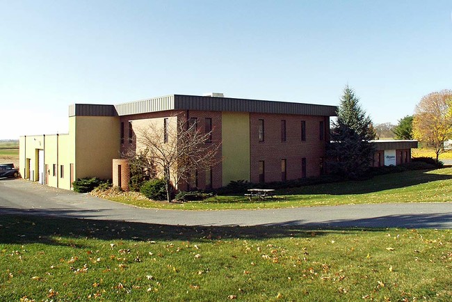
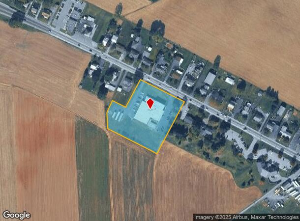
1185 Division Hwy
Lancaster, PA
David M Zimmerman
190-80528-0-0000
1185 DIVISION HWY
Officebuilding
Lancaster
X
Pennsylvania
42071C0192F
5
2024
2.70 AC
2025
Lancaster County
012900
Philadelphia
20,048 SF
DEMOGRAPHICS near 1185 Division Hwy
1 Mile
3 Mile
5 Mile
2024 Total Population
577
20,936
57,378
2029 Population
575
21,044
57,563
Pop Growth 2024-2029
(0.35%)
+ 0.52%
+ 0.32%
Average Age
41
39
40
2024 Total Households
188
7,859
21,552
HH Growth 2024-2029
(0.53%)
+ 0.62%
+ 0.39%
Median Household Inc
$77,155
$64,735
$70,022
Avg Household Size
2.80
2.50
2.60
2024 Avg HH Vehicles
2.00
2.00
2.00
Median Home Value
$326,316
$222,024
$234,418
Median Year Built
1971
1973
1976
Nearby Places
Map Layers
Map Styles
 Street
 Aerial
- Restaurants
- Banks
- Shops
- Fitness
- Groceries
PUBLIC TRANSPORTATION
AIRPORT
Harrisburg International
DRIVE
WALK
Distance
Harrisburg International
54 min
42.5 mi
Freight Ports
Port Newark Container Terminal
DRIVE
WALK
Distance
Port Newark Container Terminal
87 min
50.0 mi
Nearby Properties
Address
Land Use
TOTAL SIZE
Lot Size
Zoning
Address
Land Use
TOTAL SIZE
Lot Size
Zoning
251,634 SF
16.28 AC
Address
Land Use
TOTAL SIZE
Lot Size
Zoning
229,049 SF
26.80 AC
RLD
Address
Land Use
TOTAL SIZE
Lot Size
Zoning
166,771 SF
10.76 AC
Address
Land Use
TOTAL SIZE
Lot Size
Zoning
155,373 SF
4.50 AC
Address
Land Use
TOTAL SIZE
Lot Size
Zoning
198,400 SF
36.90 AC
C-2
Address
Land Use
TOTAL SIZE
Lot Size
Zoning
154,041 SF
12.78 AC
Address
Land Use
TOTAL SIZE
Lot Size
Zoning
69,993 SF
Address
Land Use
TOTAL SIZE
Lot Size
Zoning
152,537 SF
17.20 AC
HC
Address
Land Use
TOTAL SIZE
Lot Size
Zoning
87,464 SF
7.30 AC
R-2
Address
Land Use
TOTAL SIZE
Lot Size
Zoning
88,413 SF
5.30 AC
RMD
Address
Land Use
TOTAL SIZE
Lot Size
Zoning
85,104 SF
24.20 AC
Address
Land Use
TOTAL SIZE
Lot Size
Zoning
57,966 SF
6.03 AC
Address
Land Use
TOTAL SIZE
Lot Size
Zoning
33,134 SF
0.42 AC
NC-2
Address
Land Use
TOTAL SIZE
Lot Size
Zoning
59,996 SF
6 AC
Address
Land Use
TOTAL SIZE
Lot Size
Zoning
55,896 SF
3.49 AC
Address
Land Use
TOTAL SIZE
Lot Size
Zoning
51,954 SF
11.80 AC
R-1
Address
Land Use
TOTAL SIZE
Lot Size
Zoning
36,322 SF
7.70 AC
C-2
Address
Land Use
TOTAL SIZE
Lot Size
Zoning
64,500 SF
19.60 AC
RLD
Address
Land Use
TOTAL SIZE
Lot Size
Zoning
118,332 SF
8.80 AC
RLD
Address
Land Use
TOTAL SIZE
Lot Size
Zoning
27,534 SF
25.40 AC
A
Address
Land Use
TOTAL SIZE
Lot Size
Zoning
54,298 SF
5 AC
HC
Address
Land Use
TOTAL SIZE
Lot Size
Zoning
48,150 SF
19.73 AC
I
Address
Land Use
TOTAL SIZE
Lot Size
Zoning
47,810 SF
5.08 AC
RLD
Address
Land Use
TOTAL SIZE
Lot Size
Zoning
51,064 SF
1.28 AC
Address
Land Use
TOTAL SIZE
Lot Size
Zoning
139,615 SF
11.20 AC
GI
Address
Land Use
TOTAL SIZE
Lot Size
Zoning
84,923 SF
6 AC
C
Address
Land Use
TOTAL SIZE
Lot Size
Zoning
20,116 SF
3.50 AC
HC
Address
Land Use
TOTAL SIZE
Lot Size
Zoning
47,875 SF
9.90 AC
RHD
Address
Land Use
TOTAL SIZE
Lot Size
Zoning
28,640 SF
1.86 AC
CB
Address
Land Use
TOTAL SIZE
Lot Size
Zoning
123,436 SF
8.90 AC
I
The World's #1 Commercial Real Estate Marketplace
Connect with us
© 2025 CoStar Group
The information above has been obtained from sources believed reliable. While we do not doubt its accuracy we have not verified it and make no guarantee, warranty or representation about it. It is your responsibility to independently confirm its accuracy and completeness. Any projections, opinions, assumptions, or estimates used are for example only and do not represent the current or future performance of the property. The value of this transaction to you depends on tax and other factors which should be evaluated by your tax, financial, and legal advisors. You and your advisors should conduct a careful, independent investigation of the property to determine to your satisfaction the suitability of the property for your needs.