Property Record
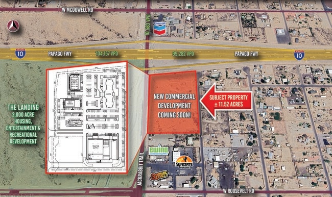
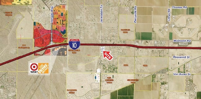
1185 N Jackrabbit Trl, Buckeye, AZ 85326

This Property Is For Sale
Property Detail
1185 N Jackrabbit Trl
Phoenix-Mesa-Chandler, AZ
NW4 NW4 SW4 NW4 EX W 40F RD
502-36-024
MARICOPA
Commercialacreage
Arizona
C-C
4.51 AC
2025
West I-10
2025
Phoenix
050612
NEARBY LISTINGS FOR SALE OR LEASE
DEMOGRAPHICS near 1185 N Jackrabbit Trl
1 mile
3 mile
5 mile
2025 Total Population
2,865
38,763
114,883
2030 Population
3,026
41,658
122,948
Pop Growth 2025-2030
+ 5.62%
+ 7.47%
+ 7.02%
Average Age
36
36
39
2025 Total Households
837
11,786
37,109
HH Growth 2025-2030
+ 5.62%
+ 7.52%
+ 7.23%
Median Household Inc
$106,656
$114,045
$113,609
Avg Household Size
3.20
3.20
3.00
2025 Avg HH Vehicles
2.00
2.00
2.00
Median Home Value
$429,609
$482,393
$497,214
Median Year Built
2009
2010
2010
Nearby Places
Map Layers
Map Styles
 Street
 Aerial
Layers
 Traffic
 Biking
Places
Listings with unknown addresses are not visible on the map
- Restaurants
- Banks
- Shops
- Fitness
- Groceries
PUBLIC TRANSPORTATION
AIRPORT
Phoenix Sky Harbor International
Drive
Walk
Distance
Phoenix Sky Harbor International
39 min
30.2 mi
Freight Ports
Port of San Diego
Drive
Walk
Distance
Port of San Diego
368 min
331.8 mi
Nearby Properties
Address
Land Use
TOTAL SIZE
Lot Size
Zoning
Address
Land Use
TOTAL SIZE
Lot Size
Zoning
18.73 AC
Address
Land Use
TOTAL SIZE
Lot Size
Zoning
551,831 SF
609.49 AC
AG
Address
Land Use
TOTAL SIZE
Lot Size
Zoning
196,353 SF
13.05 AC
C-C
Address
Land Use
TOTAL SIZE
Lot Size
Zoning
438,256 SF
48.59 AC
Address
Land Use
TOTAL SIZE
Lot Size
Zoning
13.35 AC
Address
Land Use
TOTAL SIZE
Lot Size
Zoning
9.44 AC
Address
Land Use
TOTAL SIZE
Lot Size
Zoning
721,156 SF
44.90 AC
PAD
Address
Land Use
TOTAL SIZE
Lot Size
Zoning
11.14 AC
Address
Land Use
TOTAL SIZE
Lot Size
Zoning
231,044 SF
48.70 AC
Address
Land Use
TOTAL SIZE
Lot Size
Zoning
19.06 AC
Address
Land Use
TOTAL SIZE
Lot Size
Zoning
1,056,353 SF
59.84 AC
Address
Land Use
TOTAL SIZE
Lot Size
Zoning
249,623 SF
50.12 AC
PAD
Address
Land Use
TOTAL SIZE
Lot Size
Zoning
185,251 SF
13.29 AC
PAD
Address
Land Use
TOTAL SIZE
Lot Size
Zoning
4.46 AC
Address
Land Use
TOTAL SIZE
Lot Size
Zoning
179,632 SF
16.64 AC
PR
Address
Land Use
TOTAL SIZE
Lot Size
Zoning
226,139 SF
19.46 AC
PAD
Address
Land Use
TOTAL SIZE
Lot Size
Zoning
152,901 SF
22.52 AC
Address
Land Use
TOTAL SIZE
Lot Size
Zoning
Address
Land Use
TOTAL SIZE
Lot Size
Zoning
156,060 SF
12.04 AC
R-43
Address
Land Use
TOTAL SIZE
Lot Size
Zoning
82,692 SF
23.68 AC
Address
Land Use
TOTAL SIZE
Lot Size
Zoning
108,281 SF
11.95 AC
PC
Address
Land Use
TOTAL SIZE
Lot Size
Zoning
12,418 SF
54.25 AC
PC
Address
Land Use
TOTAL SIZE
Lot Size
Zoning
91,505 SF
16.57 AC
PAD
Address
Land Use
TOTAL SIZE
Lot Size
Zoning
80,531 SF
7.51 AC
PAD
The World's #1 Commercial Real Estate Marketplace
Connect with us
© 2026 CoStar Group
The information above has been obtained from sources believed reliable. While we do not doubt its accuracy we have not verified it and make no guarantee, warranty or representation about it. It is your responsibility to independently confirm its accuracy and completeness. Any projections, opinions, assumptions, or estimates used are for example only and do not represent the current or future performance of the property. The value of this transaction to you depends on tax and other factors which should be evaluated by your tax, financial, and legal advisors. You and your advisors should conduct a careful, independent investigation of the property to determine to your satisfaction the suitability of the property for your needs.