Property Record
11850 W Fillmore St, Avondale, AZ 85323

NEARBY LISTINGS FOR SALE OR LEASE
Property Detail
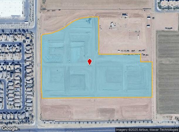
11850 W Fillmore St
Coldwater
Fuze 623 & Flatz 623
Phoenix
176517 FUZE 623 & FLATZ 623
Phoenix-Mesa-Scottsdale, AZ
Maricopa
500-01-608
Arizona
Farms
3
2025
18.27 AC
2025
DEMOGRAPHICS near 11850 W Fillmore St
1 Mile
3 Mile
5 Mile
2024 Total Population
12,777
100,951
244,557
2029 Population
13,966
107,969
265,313
Pop Growth 2024-2029
+ 9.31%
+ 6.95%
+ 8.49%
Average Age
33
34
34
2024 Total Households
4,207
30,909
74,121
HH Growth 2024-2029
+ 9.34%
+ 6.93%
+ 8.58%
Median Household Inc
$68,780
$71,127
$77,200
Avg Household Size
3.00
3.20
3.20
2024 Avg HH Vehicles
2.00
2.00
2.00
Median Home Value
$284,518
$307,513
$324,625
Median Year Built
2005
2001
2002
Nearby Places
Map Layers
Map Styles
 Street
 Aerial
- Restaurants
- Banks
- Shops
- Fitness
- Groceries
PUBLIC TRANSPORTATION
AIRPORT
Phoenix Sky Harbor International
DRIVE
WALK
Distance
Phoenix Sky Harbor International
28 min
20.4 mi
Freight Ports
Port of San Diego
DRIVE
WALK
Distance
Port of San Diego
380 min
341.3 mi
Nearby Properties
Address
Land Use
TOTAL SIZE
Lot Size
Zoning
Address
Land Use
TOTAL SIZE
Lot Size
Zoning
12.04 AC
Address
Land Use
TOTAL SIZE
Lot Size
Zoning
12.80 AC
Address
Land Use
TOTAL SIZE
Lot Size
Zoning
206.08 AC
PAD
Address
Land Use
TOTAL SIZE
Lot Size
Zoning
49,475 SF
5.70 AC
PAD
Address
Land Use
TOTAL SIZE
Lot Size
Zoning
370,726 SF
23.41 AC
PAD
Address
Land Use
TOTAL SIZE
Lot Size
Zoning
Address
Land Use
TOTAL SIZE
Lot Size
Zoning
Address
Land Use
TOTAL SIZE
Lot Size
Zoning
324,374 SF
18.26 AC
PAD
Address
Land Use
TOTAL SIZE
Lot Size
Zoning
889,089 SF
83.11 AC
I-1
Address
Land Use
TOTAL SIZE
Lot Size
Zoning
90,008 SF
20.42 AC
M-H
Address
Land Use
TOTAL SIZE
Lot Size
Zoning
177,052 SF
2.69 AC
THEBLVDD
Address
Land Use
TOTAL SIZE
Lot Size
Zoning
401,714 SF
100.01 AC
PAD
Address
Land Use
TOTAL SIZE
Lot Size
Zoning
287,294 SF
67.46 AC
PAD
Address
Land Use
TOTAL SIZE
Lot Size
Zoning
301,329 SF
50.60 AC
AG
Address
Land Use
TOTAL SIZE
Lot Size
Zoning
296,791 SF
35 AC
PAD
Address
Land Use
TOTAL SIZE
Lot Size
Zoning
369,413 SF
16.39 AC
THEBLVDD
Address
Land Use
TOTAL SIZE
Lot Size
Zoning
432,022 SF
19.33 AC
PAD
Address
Land Use
TOTAL SIZE
Lot Size
Zoning
797,310 SF
36.82 AC
I-1
Address
Land Use
TOTAL SIZE
Lot Size
Zoning
628,480 SF
34.45 AC
PAD
Address
Land Use
TOTAL SIZE
Lot Size
Zoning
397,132 SF
27.52 AC
I1
Address
Land Use
TOTAL SIZE
Lot Size
Zoning
409,088 SF
21.34 AC
PAD
Address
Land Use
TOTAL SIZE
Lot Size
Zoning
353,155 SF
16.80 AC
M-H
Address
Land Use
TOTAL SIZE
Lot Size
Zoning
340,061 SF
15.50 AC
M-H
Address
Land Use
TOTAL SIZE
Lot Size
Zoning
327,840 SF
22.20 AC
PAD
Address
Land Use
TOTAL SIZE
Lot Size
Zoning
332,075 SF
19.15 AC
C2
Address
Land Use
TOTAL SIZE
Lot Size
Zoning
274,700 SF
23.23 AC
PAD
Address
Land Use
TOTAL SIZE
Lot Size
Zoning
191,303 SF
37.42 AC
R-6
Address
Land Use
TOTAL SIZE
Lot Size
Zoning
6,472 SF
1.14 AC
PAD
Address
Land Use
TOTAL SIZE
Lot Size
Zoning
232,797 SF
25.43 AC
PAD
The World's #1 Commercial Real Estate Marketplace
Connect with us
© 2025 CoStar Group
The information above has been obtained from sources believed reliable. While we do not doubt its accuracy we have not verified it and make no guarantee, warranty or representation about it. It is your responsibility to independently confirm its accuracy and completeness. Any projections, opinions, assumptions, or estimates used are for example only and do not represent the current or future performance of the property. The value of this transaction to you depends on tax and other factors which should be evaluated by your tax, financial, and legal advisors. You and your advisors should conduct a careful, independent investigation of the property to determine to your satisfaction the suitability of the property for your needs.