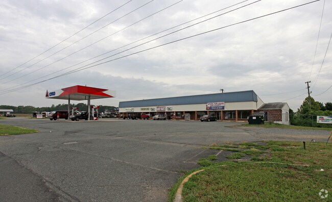
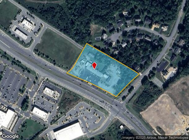
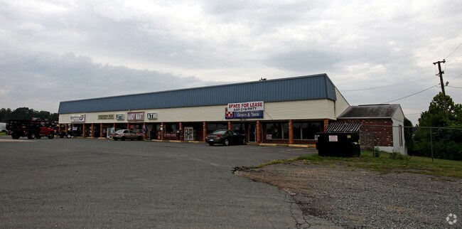
Property Record
1186 Warrenton Rd, Fredericksburg, VA 22406
NEARBY LISTINGS FOR SALE OR LEASE
Property Detail
1186 Warrenton Rd
44-63
Fauquier
Storebuilding
FAUQUIER 4.2076 AC
X
Stafford
51179C0182F
Virginia
2024
4.21 AC
2025
Stafford County
010305
Washington, DC
5,520 SF
Washington-Arlington-Alexandria, DC-VA-MD-WV
DEMOGRAPHICS near 1186 Warrenton Rd
1 Mile
3 Mile
5 Mile
2024 Total Population
4,124
21,524
51,495
2029 Population
4,580
24,016
57,086
Pop Growth 2024-2029
+ 11.06%
+ 11.58%
+ 10.86%
Average Age
38
40
38
2024 Total Households
1,325
7,991
18,911
HH Growth 2024-2029
+ 11.09%
+ 11.64%
+ 10.83%
Median Household Inc
$132,865
$96,963
$88,189
Avg Household Size
3.10
2.70
2.70
2024 Avg HH Vehicles
3.00
2.00
2.00
Median Home Value
$414,531
$394,124
$393,878
Median Year Built
2000
2003
1999
Nearby Places
- Restaurants
- Banks
- Shops
- Fitness
- Groceries
PUBLIC TRANSPORTATION
COMMUTER RAIL
Fredericksburg (Fredericksburg Line - Virginia Railway Express)
DRIVE
WALK
Distance
Fredericksburg (Fredericksburg Line - Virginia Railway Express)
14 min
7.5 mi
Leeland Road (Fredericksburg Line - Virginia Railway Express)
DRIVE
WALK
Distance
Leeland Road (Fredericksburg Line - Virginia Railway Express)
16 min
8.5 mi
Freight Ports
Virginia Port Authority - Richmond
DRIVE
WALK
Distance
Virginia Port Authority - Richmond
84 min
68.5 mi
Nearby Properties
Address
Land Use
TOTAL SIZE
Lot Size
Zoning
Address
Land Use
TOTAL SIZE
Lot Size
Zoning
607,877 SF
47.89 AC
B2
Address
Land Use
TOTAL SIZE
Lot Size
Zoning
188 SF
14.96 AC
R2
Address
Land Use
TOTAL SIZE
Lot Size
Zoning
200 SF
17.92 AC
B2
Address
Land Use
TOTAL SIZE
Lot Size
Zoning
200,453 SF
14.73 AC
RBC
Address
Land Use
TOTAL SIZE
Lot Size
Zoning
168 SF
11.77 AC
R2
Address
Land Use
TOTAL SIZE
Lot Size
Zoning
51.20 AC
B2
Address
Land Use
TOTAL SIZE
Lot Size
Zoning
610,866 SF
37.59 AC
M1
Address
Land Use
TOTAL SIZE
Lot Size
Zoning
186,909 SF
9.91 AC
RBC
Address
Land Use
TOTAL SIZE
Lot Size
Zoning
340 SF
20.86 AC
R2
Address
Land Use
TOTAL SIZE
Lot Size
Zoning
164,579 SF
11.81 AC
M1
Address
Land Use
TOTAL SIZE
Lot Size
Zoning
102,451 SF
11.99 AC
R3
Address
Land Use
TOTAL SIZE
Lot Size
Zoning
194,051 SF
9.71 AC
LC
Address
Land Use
TOTAL SIZE
Lot Size
Zoning
120 SF
9.46 AC
R2
Address
Land Use
TOTAL SIZE
Lot Size
Zoning
101,137 SF
48.17 AC
R1
Address
Land Use
TOTAL SIZE
Lot Size
Zoning
161,672 SF
11.15 AC
R3
Address
Land Use
TOTAL SIZE
Lot Size
Zoning
65,988 SF
216.41 AC
B2
Address
Land Use
TOTAL SIZE
Lot Size
Zoning
146,349 SF
39.98 AC
R2
Address
Land Use
TOTAL SIZE
Lot Size
Zoning
8.14 AC
R2
Address
Land Use
TOTAL SIZE
Lot Size
Zoning
192,254 SF
23.57 AC
B2
Address
Land Use
TOTAL SIZE
Lot Size
Zoning
140,400 SF
20.60 AC
M1
Address
Land Use
TOTAL SIZE
Lot Size
Zoning
87,900 SF
20 AC
M1
Address
Land Use
TOTAL SIZE
Lot Size
Zoning
56,774 SF
9.87 AC
B2
Address
Land Use
TOTAL SIZE
Lot Size
Zoning
Address
Land Use
TOTAL SIZE
Lot Size
Zoning
137,587 SF
18.08 AC
M1
Address
Land Use
TOTAL SIZE
Lot Size
Zoning
139,407 SF
13.35 AC
B2
Address
Land Use
TOTAL SIZE
Lot Size
Zoning
125,671 SF
11.73 AC
B2
Address
Land Use
TOTAL SIZE
Lot Size
Zoning
82 SF
10.15 AC
R2
Address
Land Use
TOTAL SIZE
Lot Size
Zoning
132,073 SF
11.11 AC
M1
Address
Land Use
TOTAL SIZE
Lot Size
Zoning
48,418 SF
5 AC
LC
Address
Land Use
TOTAL SIZE
Lot Size
Zoning
42,150 SF
5.46 AC
LC
The World's #1 Commercial Real Estate Marketplace
Connect with us
© 2025 CoStar Group
The information above has been obtained from sources believed reliable. While we do not doubt its accuracy we have not verified it and make no guarantee, warranty or representation about it. It is your responsibility to independently confirm its accuracy and completeness. Any projections, opinions, assumptions, or estimates used are for example only and do not represent the current or future performance of the property. The value of this transaction to you depends on tax and other factors which should be evaluated by your tax, financial, and legal advisors. You and your advisors should conduct a careful, independent investigation of the property to determine to your satisfaction the suitability of the property for your needs.