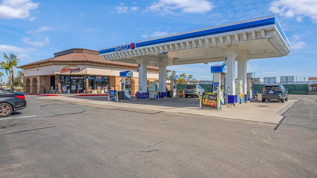
Property Record
1187 W San Marcos Blvd, San Marcos, CA 92078


NEARBY LISTINGS FOR SALE OR LEASE
Property Detail
1187 W San Marcos Blvd
San Diego-Carlsbad, CA
Rancho Los Vallecitos De San M
221-051-52
PAR 1 (EX ST) TR PM16303
Servicestationmarket
San Diego
X
California
06073C0789H
3
2024
0.57 AC
2025
San Marcos
020029
San Diego
2,688 SF
DEMOGRAPHICS near 1187 W San Marcos Blvd
1 Mile
3 Mile
5 Mile
2024 Total Population
11,391
96,591
198,931
2029 Population
11,355
95,677
197,427
Pop Growth 2024-2029
(0.32%)
(0.95%)
(0.76%)
Average Age
42
38
40
2024 Total Households
4,138
31,766
68,868
HH Growth 2024-2029
(0.41%)
(1.03%)
(0.90%)
Median Household Inc
$74,142
$99,812
$106,903
Avg Household Size
2.60
2.90
2.80
2024 Avg HH Vehicles
2.00
2.00
2.00
Median Home Value
$635,393
$778,058
$793,442
Median Year Built
1982
1994
1988
Nearby Places
Map Layers
Map Styles
 Street
 Aerial
- Restaurants
- Banks
- Shops
- Fitness
- Groceries
PUBLIC TRANSPORTATION
COMMUTER RAIL
Carlsbad Poinsettia (Coaster - San Diego North County Transit District (Coaster/Sprinter/Breeze))
DRIVE
WALK
Distance
Carlsbad Poinsettia (Coaster - San Diego North County Transit District (Coaster/Sprinter/Breeze))
16 min
9.1 mi
AIRPORT
San Diego International
DRIVE
WALK
Distance
San Diego International
45 min
32.7 mi
Freight Ports
Port of San Diego
DRIVE
WALK
Distance
Port of San Diego
50 min
38.3 mi
SALE & LEASE HISTORY
LISTING DATE
SALE/LEASE

Mar 05, 2025
For Sale
Nearby Properties
Address
Land Use
TOTAL SIZE
Lot Size
Zoning
Address
Land Use
TOTAL SIZE
Lot Size
Zoning
27.98 AC
SPA
Address
Land Use
TOTAL SIZE
Lot Size
Zoning
15.37 AC
SPA
Address
Land Use
TOTAL SIZE
Lot Size
Zoning
5.25 AC
SPA
Address
Land Use
TOTAL SIZE
Lot Size
Zoning
5.37 AC
SPA
Address
Land Use
TOTAL SIZE
Lot Size
Zoning
10.82 AC
SPA
Address
Land Use
TOTAL SIZE
Lot Size
Zoning
28.45 AC
O-S
Address
Land Use
TOTAL SIZE
Lot Size
Zoning
11.87 AC
R-M
Address
Land Use
TOTAL SIZE
Lot Size
Zoning
9.41 AC
SPI
Address
Land Use
TOTAL SIZE
Lot Size
Zoning
16.91 AC
C
Address
Land Use
TOTAL SIZE
Lot Size
Zoning
11.08 AC
SPI
Address
Land Use
TOTAL SIZE
Lot Size
Zoning
9.88 AC
R-3-10
Address
Land Use
TOTAL SIZE
Lot Size
Zoning
SPECIFIC P
Address
Land Use
TOTAL SIZE
Lot Size
Zoning
11.49 AC
P-M
Address
Land Use
TOTAL SIZE
Lot Size
Zoning
4.76 AC
C34
Address
Land Use
TOTAL SIZE
Lot Size
Zoning
9.80 AC
I
Address
Land Use
TOTAL SIZE
Lot Size
Zoning
7.91 AC
SPI
Address
Land Use
TOTAL SIZE
Lot Size
Zoning
19.35 AC
P-M
Address
Land Use
TOTAL SIZE
Lot Size
Zoning
27.30 AC
SPI
Address
Land Use
TOTAL SIZE
Lot Size
Zoning
19.68 AC
SPI
Address
Land Use
TOTAL SIZE
Lot Size
Zoning
10.80 AC
SPA
Address
Land Use
TOTAL SIZE
Lot Size
Zoning
1.94 AC
C
Address
Land Use
TOTAL SIZE
Lot Size
Zoning
9.99 AC
MU-1
Address
Land Use
TOTAL SIZE
Lot Size
Zoning
4.65 AC
SPI
Address
Land Use
TOTAL SIZE
Lot Size
Zoning
7.33 AC
R-M
Address
Land Use
TOTAL SIZE
Lot Size
Zoning
8.07 AC
SPI
Address
Land Use
TOTAL SIZE
Lot Size
Zoning
1.49 AC
SPA
Address
Land Use
TOTAL SIZE
Lot Size
Zoning
7.54 AC
SPA
Address
Land Use
TOTAL SIZE
Lot Size
Zoning
Address
Land Use
TOTAL SIZE
Lot Size
Zoning
5.85 AC
SPA
Address
Land Use
TOTAL SIZE
Lot Size
Zoning
99,840 SF
5.20 AC
SPI
The World's #1 Commercial Real Estate Marketplace
Connect with us
© 2026 CoStar Group
The information above has been obtained from sources believed reliable. While we do not doubt its accuracy we have not verified it and make no guarantee, warranty or representation about it. It is your responsibility to independently confirm its accuracy and completeness. Any projections, opinions, assumptions, or estimates used are for example only and do not represent the current or future performance of the property. The value of this transaction to you depends on tax and other factors which should be evaluated by your tax, financial, and legal advisors. You and your advisors should conduct a careful, independent investigation of the property to determine to your satisfaction the suitability of the property for your needs.