Property Record
11870 W 135Th St, Overland Park, KS 66221
NEARBY LISTINGS FOR SALE OR LEASE
Property Detail
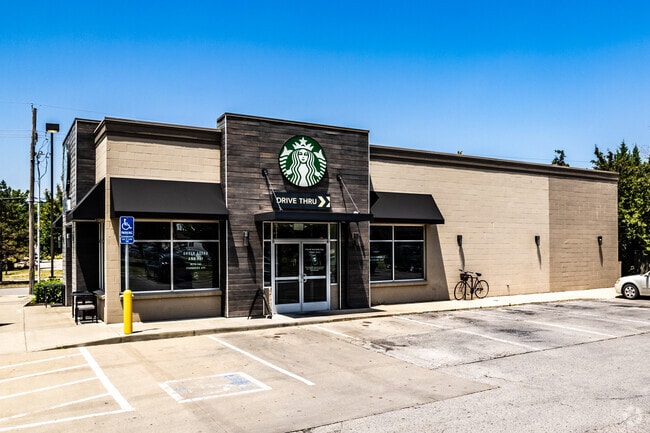
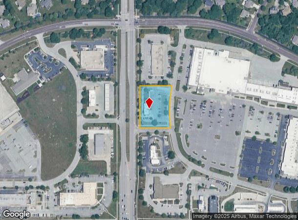
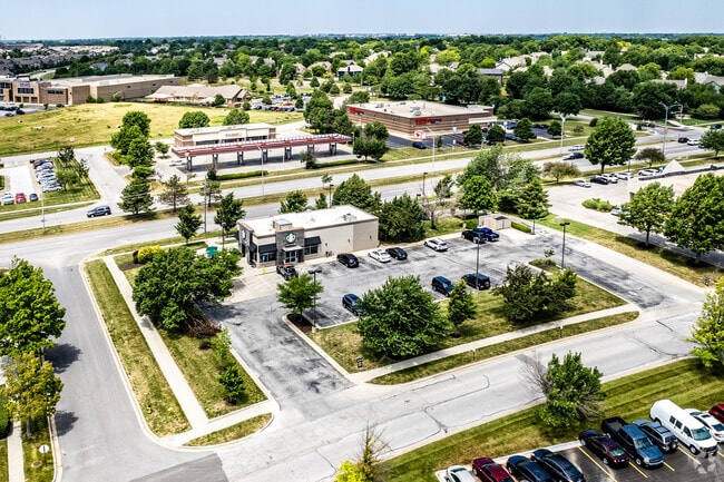
11870 W 135Th St
Kansas City, MO-KS
135Th & Quivira Price Chopper Centre
NP57730000-0003
135TH & QUIVIRA PRICE CHOPPER CENTRE LT 3 OPC 176A 3
Restaurantdrivein
Johnson
X
Kansas
20091C0081G
3
2024
1.14 AC
2024
South Johnson County
053010
Kansas City
2,216 SF
DEMOGRAPHICS near 11870 W 135Th St
1 Mile
3 Mile
5 Mile
2024 Total Population
12,969
95,135
240,026
2029 Population
13,472
98,641
249,932
Pop Growth 2024-2029
+ 3.88%
+ 3.69%
+ 4.13%
Average Age
39
39
39
2024 Total Households
5,029
37,472
93,287
HH Growth 2024-2029
+ 4.04%
+ 3.86%
+ 4.29%
Median Household Inc
$113,947
$105,902
$99,014
Avg Household Size
2.50
2.50
2.50
2024 Avg HH Vehicles
2.00
2.00
2.00
Median Home Value
$427,760
$369,525
$346,014
Median Year Built
2000
1994
1992
Nearby Places
Map Layers
Map Styles
 Street
 Aerial
- Restaurants
- Banks
- Shops
- Fitness
- Groceries
PUBLIC TRANSPORTATION
AIRPORT
Kansas City International
DRIVE
WALK
Distance
Kansas City International
49 min
36.6 mi
Nearby Properties
Address
Land Use
TOTAL SIZE
Lot Size
Zoning
Address
Land Use
TOTAL SIZE
Lot Size
Zoning
1,173,824 SF
63.09 AC
R-1
Address
Land Use
TOTAL SIZE
Lot Size
Zoning
1,051,458 SF
74.32 AC
R-1
Address
Land Use
TOTAL SIZE
Lot Size
Zoning
312,726 SF
13.73 AC
RP-4
Address
Land Use
TOTAL SIZE
Lot Size
Zoning
482,713 SF
77.78 AC
AG
Address
Land Use
TOTAL SIZE
Lot Size
Zoning
247,991 SF
21.19 AC
R-1
Address
Land Use
TOTAL SIZE
Lot Size
Zoning
199,247 SF
50.19 AC
R-1
Address
Land Use
TOTAL SIZE
Lot Size
Zoning
287,599 SF
38.50 AC
R-1
Address
Land Use
TOTAL SIZE
Lot Size
Zoning
202,726 SF
9.37 AC
R-1
Address
Land Use
TOTAL SIZE
Lot Size
Zoning
40,647 SF
7.40 AC
R-4
Address
Land Use
TOTAL SIZE
Lot Size
Zoning
189,226 SF
29.81 AC
R-1
Address
Land Use
TOTAL SIZE
Lot Size
Zoning
96,100 SF
25.01 AC
R-1
Address
Land Use
TOTAL SIZE
Lot Size
Zoning
135,551 SF
12.36 AC
R-1
Address
Land Use
TOTAL SIZE
Lot Size
Zoning
89,226 SF
4.37 AC
R-1
Address
Land Use
TOTAL SIZE
Lot Size
Zoning
62,293 SF
6.50 AC
MXD
Address
Land Use
TOTAL SIZE
Lot Size
Zoning
146,832 SF
30 AC
R-1
Address
Land Use
TOTAL SIZE
Lot Size
Zoning
150,122 SF
17.48 AC
R-1
Address
Land Use
TOTAL SIZE
Lot Size
Zoning
81,820 SF
15.16 AC
R-1
Address
Land Use
TOTAL SIZE
Lot Size
Zoning
157,344 SF
12.69 AC
R-1
Address
Land Use
TOTAL SIZE
Lot Size
Zoning
94,034 SF
6.96 AC
MXD
Address
Land Use
TOTAL SIZE
Lot Size
Zoning
61,479 SF
8.14 AC
C-2
Address
Land Use
TOTAL SIZE
Lot Size
Zoning
130,605 SF
18.01 AC
R-1
Address
Land Use
TOTAL SIZE
Lot Size
Zoning
114,689 SF
60.46 AC
R-1
Address
Land Use
TOTAL SIZE
Lot Size
Zoning
121,872 SF
12.08 AC
R-1
Address
Land Use
TOTAL SIZE
Lot Size
Zoning
32,992 SF
3.85 AC
R-4
Address
Land Use
TOTAL SIZE
Lot Size
Zoning
44,738 SF
10.21 AC
CP-2
Address
Land Use
TOTAL SIZE
Lot Size
Zoning
72,253 SF
24.46 AC
R-1
Address
Land Use
TOTAL SIZE
Lot Size
Zoning
9,424 SF
5.15 AC
R-4
Address
Land Use
TOTAL SIZE
Lot Size
Zoning
52,863 SF
10.81 AC
R-1A
Address
Land Use
TOTAL SIZE
Lot Size
Zoning
122,720 SF
27.39 AC
R-1
Address
Land Use
TOTAL SIZE
Lot Size
Zoning
115,263 SF
23.66 AC
R-1
The World's #1 Commercial Real Estate Marketplace
Connect with us
© 2025 CoStar Group
The information above has been obtained from sources believed reliable. While we do not doubt its accuracy we have not verified it and make no guarantee, warranty or representation about it. It is your responsibility to independently confirm its accuracy and completeness. Any projections, opinions, assumptions, or estimates used are for example only and do not represent the current or future performance of the property. The value of this transaction to you depends on tax and other factors which should be evaluated by your tax, financial, and legal advisors. You and your advisors should conduct a careful, independent investigation of the property to determine to your satisfaction the suitability of the property for your needs.