Property Record
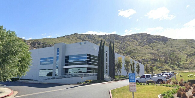
1188 Mt Vernon Ave, Riverside, CA 92507


Current Lease Availabilities
Property Detail
1188 Mt Vernon Ave
257-110-010
5.67 ACRES M/L IN POR LOTS 11 & 13 MB 002/039 VIVIENDA RANCH AND POR NW 1/4 OF SEC 16 T2S R4W FOR TOTAL DESCRIPTION SEE ASSESSORS MAPS
Lightindustrial
Riverside
MP
California
B and X Area of moderate flood hazard, usually the area between the limits of the 100-year and 500-year floods.
13
2024
5.67 AC
2025
Riverside
042214
Inland Empire (California)
81,373 SF
Riverside-San Bernardino-Ontario, CA
NEARBY LISTINGS FOR SALE OR LEASE
DEMOGRAPHICS near 1188 Mt Vernon Ave
1 mile
3 mile
5 mile
2025 Total Population
4,213
66,365
190,968
2030 Population
4,481
67,906
195,378
Pop Growth 2025-2030
+ 6.36%
+ 2.32%
+ 2.31%
Average Age
36
34
36
2025 Total Households
1,187
19,886
60,690
HH Growth 2025-2030
+ 5.98%
+ 1.85%
+ 2.03%
Median Household Inc
$127,620
$79,917
$82,596
Avg Household Size
3.40
2.90
2.90
2025 Avg HH Vehicles
3.00
2.00
2.00
Median Home Value
$704,749
$533,749
$595,036
Median Year Built
2009
1979
1980
Nearby Places
Map Layers
Map Styles
 Street
 Aerial
Layers
 Traffic
 Biking
Places
Listings with unknown addresses are not visible on the map
- Restaurants
- Banks
- Shops
- Fitness
- Groceries
PUBLIC TRANSPORTATION
COMMUTER RAIL
Riverside-Hunter Park/Ucr (Metrolink 91-Perris Valley Line - Metrolink Trains)
Drive
Walk
Distance
Riverside-Hunter Park/Ucr (Metrolink 91-Perris Valley Line - Metrolink Trains)
5 min
1.9 mi
Riverside-Downtown (91 Line - Southern California Regional Rail Authority (Metrolink), Inland Empire-Orange County Line - Southern California Regional Rail Authority (Metrolink), Riverside Line - Southern California Regional Rail Authority (Metrolink))
Drive
Walk
Distance
Riverside-Downtown (91 Line - Southern California Regional Rail Authority (Metrolink), Inland Empire-Orange County Line - Southern California Regional Rail Authority (Metrolink), Riverside Line - Southern California Regional Rail Authority (Metrolink))
11 min
5.3 mi
AIRPORT
Ontario International
Drive
Walk
Distance
Ontario International
29 min
20.3 mi
Freight Ports
Port of Long Beach
Drive
Walk
Distance
Port of Long Beach
79 min
61.1 mi
Nearby Properties
Address
Land Use
TOTAL SIZE
Lot Size
Zoning
Address
Land Use
TOTAL SIZE
Lot Size
Zoning
1,009,120 SF
35.22 AC
Address
Land Use
TOTAL SIZE
Lot Size
Zoning
494,575 SF
25.33 AC
MP
Address
Land Use
TOTAL SIZE
Lot Size
Zoning
369,842 SF
16.35 AC
Address
Land Use
TOTAL SIZE
Lot Size
Zoning
411,707 SF
19.34 AC
Address
Land Use
TOTAL SIZE
Lot Size
Zoning
26,879 SF
16.27 AC
R3
Address
Land Use
TOTAL SIZE
Lot Size
Zoning
217,036 SF
1.66 AC
C2
Address
Land Use
TOTAL SIZE
Lot Size
Zoning
245,476 SF
15.61 AC
Address
Land Use
TOTAL SIZE
Lot Size
Zoning
36,010 SF
11.76 AC
R3
Address
Land Use
TOTAL SIZE
Lot Size
Zoning
182,446 SF
9.01 AC
Address
Land Use
TOTAL SIZE
Lot Size
Zoning
415,990 SF
5.16 AC
Address
Land Use
TOTAL SIZE
Lot Size
Zoning
307,163 SF
16.65 AC
Address
Land Use
TOTAL SIZE
Lot Size
Zoning
230,063 SF
11.06 AC
Address
Land Use
TOTAL SIZE
Lot Size
Zoning
26.48 AC
R3
Address
Land Use
TOTAL SIZE
Lot Size
Zoning
304,560 SF
16.79 AC
IP
Address
Land Use
TOTAL SIZE
Lot Size
Zoning
122,738 SF
10.77 AC
Address
Land Use
TOTAL SIZE
Lot Size
Zoning
Address
Land Use
TOTAL SIZE
Lot Size
Zoning
156,998 SF
11.90 AC
MP
Address
Land Use
TOTAL SIZE
Lot Size
Zoning
8.81 AC
R3S3
Address
Land Use
TOTAL SIZE
Lot Size
Zoning
106,065 SF
6.50 AC
MP
Address
Land Use
TOTAL SIZE
Lot Size
Zoning
17,542 SF
8.27 AC
R1
Address
Land Use
TOTAL SIZE
Lot Size
Zoning
173,733 SF
10.16 AC
MP
Address
Land Use
TOTAL SIZE
Lot Size
Zoning
746,428 SF
14.20 AC
MP
Address
Land Use
TOTAL SIZE
Lot Size
Zoning
251,550 SF
12.43 AC
Address
Land Use
TOTAL SIZE
Lot Size
Zoning
97,920 SF
6.49 AC
BMP
Address
Land Use
TOTAL SIZE
Lot Size
Zoning
569,984 SF
26.50 AC
Address
Land Use
TOTAL SIZE
Lot Size
Zoning
97,787 SF
3.40 AC
Address
Land Use
TOTAL SIZE
Lot Size
Zoning
150,109 SF
6.66 AC
IP
The World's #1 Commercial Real Estate Marketplace
Connect with us
© 2026 CoStar Group
The information above has been obtained from sources believed reliable. While we do not doubt its accuracy we have not verified it and make no guarantee, warranty or representation about it. It is your responsibility to independently confirm its accuracy and completeness. Any projections, opinions, assumptions, or estimates used are for example only and do not represent the current or future performance of the property. The value of this transaction to you depends on tax and other factors which should be evaluated by your tax, financial, and legal advisors. You and your advisors should conduct a careful, independent investigation of the property to determine to your satisfaction the suitability of the property for your needs.